Marcos Serrano Ulloa, Jefe Depto. de Estadísticas e Informacíon ambiental
This email address is being protected from spambots. You need JavaScript enabled to view it.
In Chile, the second phase of the international cooperation project “South Pacific Information and Data Network to support Integrated Coastal Area Management” (SPINCAM), directed by the International Oceanographic Commission COI-UNESCO and the Permanent Commission of the South Pacific (CPPS), began in 2012. It had as the lead agency the National Ministry of Foreign Affairs and as the technical lead agency the Ministry of Environment, the institution responsible by the storing and maintaining data collections.
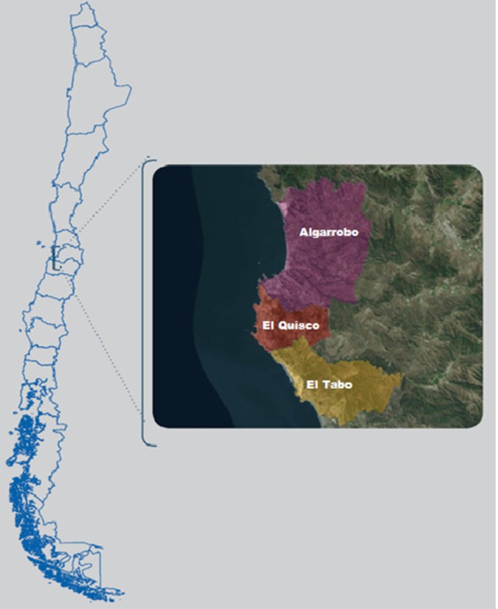
Figure 1: Geographical representation of the communes that make up the Pilot Case
In 2012, the Ministry of Environment, through of exempt resolution N° 0179 created the Inter-Institutional Committee for Environmental Information in order to coordinate public environmental information. Also, under this committee was created in 2014 the Subcommittee of Coastal and Marine Information, with the target to provide and validate specific information for the coastal and marine area, which would be key in coordinating and managing SPINCAM project activities at the national level.
This subcommittee is made up for representatives of the various institutions and / or public services that have a direct relationship with the administration and management of the coastal and marine borders, such as the Undersecretary of Fisheries and Aquaculture (SUBPESCA in Spanish), which is mainly responsible for the regulations and regulatory framework for the fishing and aquaculture activities of the country; the Institute for Fisheries Promotion (IFOP in Spanish) dedicated to research; The National Fisheries and Aquaculture Service (SERNAPESCA in Spanish), the service with inspection powers and sanitary management in relation to fishing activities and extraction of resources; the Undersecretary for the Armed Forces (SSFFAA), the institution directly related to use of the coastal border; and finally, the managing body of maritime activity at the National level, the General Directorate of Maritime Territory and Merchant Marine (DIRECTEMAR in Spanish).
During 2015, an analysis of the information and data available in the institutions that make up the Subcommittee was made, in order to build a set of indicators that contribute to integrated management of the Coastal and Marine borders. Based on the data provided by these agencies, it was possible to create indicators that account for pressures on coastal and marine ecosystems. (e.g.: the number of aquaculture and maritime concessions at national level, catch and landing quotas of the main commercial species, environmental emergencies occurring in marine areas, either anthropogenic (oil spills) or natural (red tide). The later is measured through the relative abundance of some micro algae carrying poisons or harmful algal blooms (FAN).
Also, indicators related to the state of biodiversity were constructed based on sea lions censuses, cetacean sightings, and evolution of resources exploited in Benthic Resource Management Areas (AMERB in Spanish).
In addition, response indicators were considered that account for the inspection effort at the fisheries level through the inspections carried out by SERNAPESCA.
SPINCAM’s Pilot Case Algarrobo, El Quisco and El Tabo
In SPINCAM II‘s framework a local experimental area was considered at the local level located at Algarrobo, El Quisco and El Tabo, in the province San Antonio, in the Valparaíso Region.
The area has several Nature Sanctuaries and places of tourist interest, making it a potential tourist resort, especially in summer. In the Figure 2, are represented 3 Nature Sanctuaries located within the Pilot Project area.
In this pilot zone (Figure 1), a joint effort between the Ministry of Environment, the Municipalities of Algarrobo, El Quisco and El Tabo, and the main local actors, built a set of indicators that were included in the publication “Indicators for Integrated Coastal Zone Management: Pilot Case SPINCAM of local level Algarrobo, El Quisco and El Tabo”. The document (Figure 3), describes the environmental management developed in each local level and included a total of 26 indicators that account for the strong tourist and real estate pressures, of the state of the study area and the social and / or governmental responses to these pressures, including topics such as:
- Transient Population
- Generation of Waste at the Communal Level
- Sales by Economic Sector
- Fish Landings
- Recycling Activities
- Projects with Environmental Protection Funds
- Water Quality for Recreational Use
- Biodiversity indicators such as the census of birds in the lagoon El Peral and a census framed in the Islet Pájaro Niño.
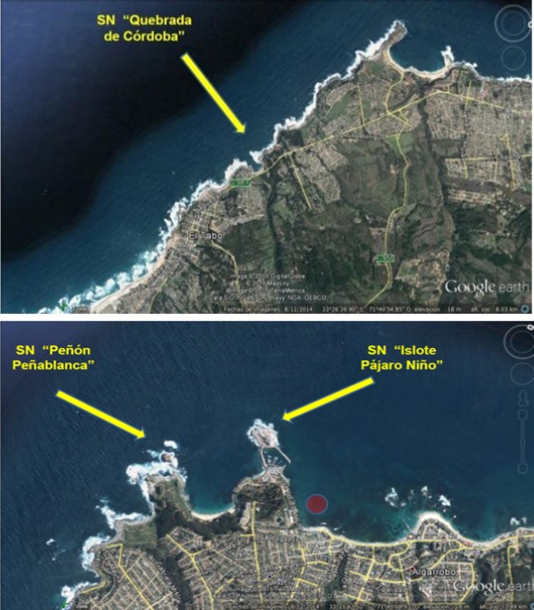
Figure 2. Nature Sanctuaries considered in the Project SPINCAM’s Pilot Case
National Environmental Information System (SINIA)
 The Ministry of Environment (MMA) administers the National Environmental Information System (SINIA in Spanish), which is the main gateway to environmental information available to the public in Chile. The functions of SINIA, defined by the Department of Environmental Information of the Ministry of Environment, articulate the environmental information of the country and make it easy and timely for citizens to access.
The dissemination mechanism protects the right of access to the environmental information to any person (Law N°19.300, 1994), in order to facilitate accessibility and exchange of information. In 2013, an improvement to SINIA was developed under international standards (Dublin Core and ISO 19.115) through a Metadata Catalog, which allows organizing the information and accessibility by citizens. The Dublin Core standard is used for the description of documentary information, indicators and databases, while the ISO 19.115 standard, describes geospatial information like a vector, images or data in raster format.
As shown in Figure 4, two other elements included in this redesign are: Spatial Data Infrastructure (IDE in Spanish) which allows the spatial visualization of environmental information and the Environmental Information Integrator System (SIIA) focused on statistical information and indicators.
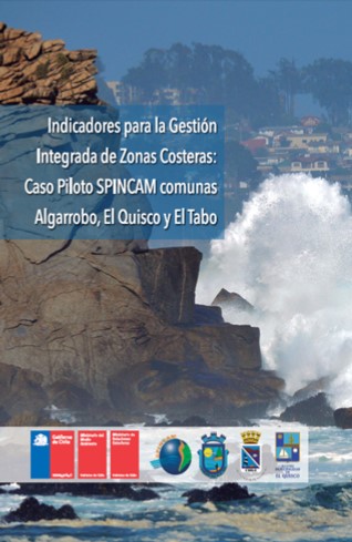
Figure 3. Cover of the publication Project SPINCAM’s Pilot Case
Considering that one of the objectives pursued in the second part of the SPINCAM project was to generate information systems that support the development of indicators and their spatial representation, it was necessary to migrate and integrate the information and data related to the SPINCAM project with the National Environmental Information System and the Spatial Data Infrastructure of Ministry of the Environment, to support the need to visualize the data and coastal-marine information through these systems, supporting decision making.
Some indicators was constructed with the information contained in the institutions1 that were included in the information analysis.
The following were considered within the section of SPINCAM that was incorporated within the SINIA:
- Indicators: You can view the indicators constructed on the analysis of information, and data available at institutional level.
- Maps: The SDI SPINCAM services are presented as:
- Migration 2002 Coastal Communes.
- Fishing Coves.
- Number of fishermen per cover.
- Landing per cover.
- Publications: There are about 100 documents and publications of the country, inside the platform Ocean Docs2, corresponding to reports of research and coastal and marine information, that considered studies related to the flora, fauna, oceanographic and socioeconomic variables located in the Coastal Marine Areas of Multiple Uses in our country, technical reports prepared by the Undersecretary of Fisheries and Aquaculture in relation to the plans of monitoring of the Areas of Management of Benthic Resources (AMERB) and studies related to marine protected species in Chile, such as cetaceans, sea lions, Humboldt penguin and other species representative of coastal protected areas, which will serve as a base line for upcoming scientific studies on the coasts Chilean.
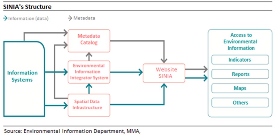
Figure 4. Scheme of the National Environmental Information System
In the next stages of SPINCAM, we expect to have the data related to the Coastal Environmental Observation Program (POAL in Spanish) that constitutes DIRECTEMAR. This program will allow the capture data of marine and freshwater environmental quality measured in different bodies of water, distributed throughout national jurisdiction, including Antarctica and Easter Island. These measurements are performed in different water bodies of jurisdiction of the Maritime Authority, and are geolocated in the SDI.
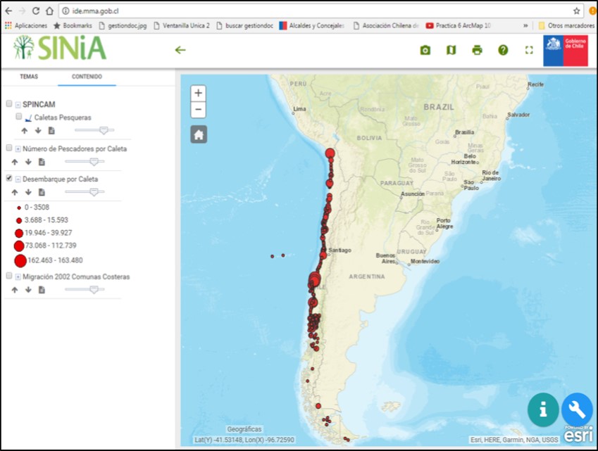
Figure 5. Map viewer of the SDI’s web portal
References
- Undersecretary of Fisheries and Aquaculture (SUBPESCA) and National Fisheries and Aquaculture Service (SERNAPESCA)
- OceanDocs - http://www.oceandocs.org/handle/1834/5392