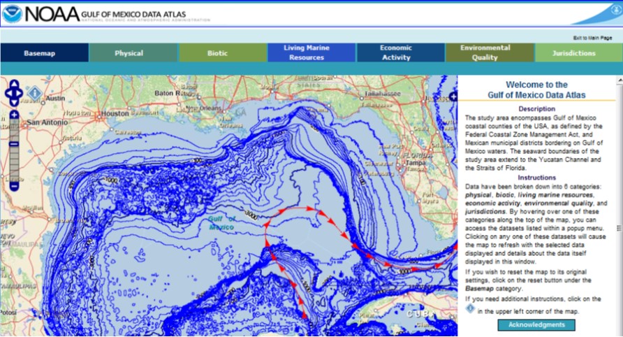
NOAA’s Gulf of Mexico Data Atlas joins ICAN
- Detalles
- Publicado: 17 Marzo 2013 17 Marzo 2013
ICAN is very pleased to welcome it's latest member, the Gulf of Mexico Data Atlas (http://gulfatlas.noaa.gov). From the atlas summary: "As plans to restore the Gulf of Mexico after recent disasters have progressed, federal and state agencies have turned to NOAA for data and information about all aspects of the Gulf of Mexico. One of the most requested resources for that data and information has been the "Gulf of Mexico Coastal and Ocean Zones Strategic Assessment Data Atlas" published by NOAA's National Ocean Service in 1985 as a large hardcopy tabletop book. The new Gulf of Mexico Data Atlas updates and expands that publication in an online, digital format."
Management and technical developments of the Venice Lagoon Atlas: a brief update
- Detalles
- Publicado: 15 Marzo 2013 15 Marzo 2013
Alessandro Mulazzani (Esta dirección de correo electrónico está siendo protegida contra los robots de spam. Necesita tener JavaScript habilitado para poder verlo.), City of Venice- Osservatorio della Laguna e del Territorio;
Claudia Ferrari (Esta dirección de correo electrónico está siendo protegida contra los robots de spam. Necesita tener JavaScript habilitado para poder verlo.), City of Venice- Osservatorio della Laguna e del Territorio;
Stefano Menegon (Esta dirección de correo electrónico está siendo protegida contra los robots de spam. Necesita tener JavaScript habilitado para poder verlo.), ISMAR-CNR,
Alessandro Sarretta (Esta dirección de correo electrónico está siendo protegida contra los robots de spam. Necesita tener JavaScript habilitado para poder verlo.), ISMAR-CNR,
Matteo Morgantin (Esta dirección de correo electrónico está siendo protegida contra los robots de spam. Necesita tener JavaScript habilitado para poder verlo.), CORILA
Andrea Rosina (Esta dirección de correo electrónico está siendo protegida contra los robots de spam. Necesita tener JavaScript habilitado para poder verlo.), CORILA
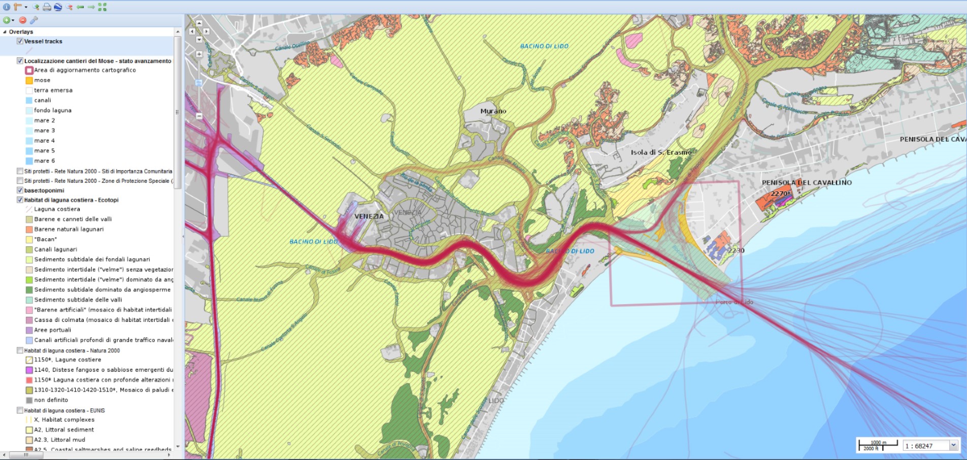
As outlined in 2011 at ICAN 5, one of the main goals of the Atlas of the Lagoon of Venice (www.atlantedellalaguna.it) is the establishment of a “federation” which should include all the bodies involved in geospatial data production for the Venice Lagoon. From the technical point of view this federation is supported by the “Collaborative Interoperable Geographic Nodes” (or CIGNo) i.e. GeoWeb platforms based on a personalised version of the GeoNode platform (http://geonode.org) developed by the Marine Science Institute of the National Research Council (ISMAR) and by the Consortium for Coordination of Research Activities Concerning the Venice Lagoon System (CORILA).
After one and a half years this goal has been reached. In April 2012, the City of Venice, the promoter of the Atlas, signed a formal agreement with the ISMAR and CORILA for joint management of the Atlas. The partners started to develop together the new Atlas CIGNo, the node to be used for the Atlas’s maps managing and publishing, connected to the already implemented ISMAR node and CORILA node.
A Working Group formed by experts from the three bodies, meet monthly to plan the development of the Atlas.
In January 2013, two major data producers joined the Working Group: the Veneto Region and the Venice Lagoon Water Authority (Magistrato alle Acque), recognising the Atlas as the key tool for accessing and sharing geographical information on the Lagoon of Venice.
In February 2013 the conversion of 355 geographical layers stored in the Atlas has been completed, to allow their publication through CIGNo. All the published maps are now accessible with the new map engine, which is more flexible and up to date.
In 2012 the www.atlantedellalaguna.com portal reached an average of 2150 visits per month.
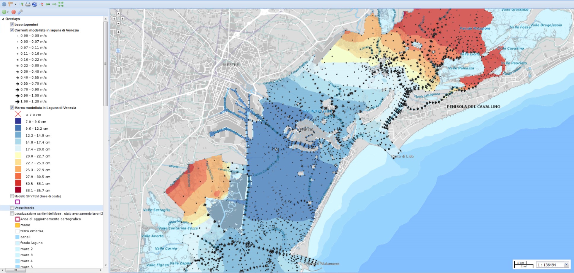
From the users point of view, the new Atlas management enriches the contents available on the geoportal (e.g.: a work carried out by ISMAR produced very interesting maps on real-time tide height and current speed, which become available quickly for the Atlas users).
The technical improvements allow a better visualisation of the maps, where extra layers can be freely added, directly from ISMAR and CORILA nodes, or from any other geoservices using the OGC’s WMS protocol.
More work needs to be done on several issues, such as Compiling standard metadata, and creating of new thematic maps. Greater interaction with users is planned, for example creating map layers with users’ contributions via smartphone app data.
The 2011 EU Commission report on “Options for coastal information systems” (http://ec.europa.eu/environment/iczm/ia_studies.htm) suggested the Atlas needed enhancements on:
- the understanding of environmental issues (climate change, pollution, subsidence, etc.);
- economic activities (i.e. fisheries);
- governance;
- scenarios; and
- evaluations of project/plans and alternatives,
However the agreement with nearly all the regional and local data producers, is favourable for the Atlas of the lagoon as an excellent pilot project demonstrating cooperation among research institutes and local/regional governments with the purpose to make environmental information available to all, for education, planning and to increase citizens’ environmental awareness.