Roy Lowry (This email address is being protected from spambots. You need JavaScript enabled to view it.) and Adam Leadbetter (This email address is being protected from spambots. You need JavaScript enabled to view it.), BODC, Liverpool, UK,
Declan Dunne(This email address is being protected from spambots. You need JavaScript enabled to view it.) and Yassine Lassoued (This email address is being protected from spambots. You need JavaScript enabled to view it.) , CMRC, Cork, Ireland,
Tanya Haddad (This email address is being protected from spambots. You need JavaScript enabled to view it.), Oregon Coastal Atlas Project, USA,
Liz O’Dea (This email address is being protected from spambots. You need JavaScript enabled to view it.) State of Washington Department of Ecology, USA
The development of ICAN semantics began with the assembly of a Coastal Erosion ontology to support semantically-enabled atlas layer discovery following the workshop at Corvallis in 2007. Semantically-enabled, or ‘smart’, discovery is where terms supplied by the search client are used to locate metadata that has been marked up using different but semantically related terms. A much quoted example is a search that returns datasets tagged ‘rainfall’ for a search term of ‘precipitation’.
This work was based on strategies and technologies provided by the Marine Metadata Interoperability (MMI) initiative. The strategy adopted was to take local vocabularies and ontologies, convert them into Web Ontology Language(OWL) classes using tools like Protégé or TopBraid Composer and then map them to a global ontology, again comprising OWL classes, using the MMI VINE tool.
Some initial work, the conversion of local vocabularies from the Irish MIDA and Oregon coastal atlases into OWL, was completed but very little mapping work was done subsequently. The possibility was mooted that the OWL-based approach, particularly some of the tools, created a technological barrier that people were unwilling to surmount. Consequently, in the NETMAR project (see below) an approach was taken where tools such as Microsoft Excel were used to assemble the local vocabularies and the mappings as a series of spreadsheets. These were then imported into an Oracle database and exported by a Java software layer (the NERC Vocabulary Server or NVS) as a thesaurus conforming to the W3C Simple Knowledge Organisation System (SKOS) standard.
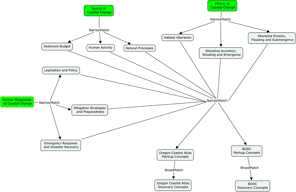
Figure 1. ICAN Coastal Erosion Mapping
As a part of this work, the mapping between the Oregon Coastal Atlas and the ICAN Coastal Erosion Global Atlas was completed as shown in Figure 1. The resulting thesaurus is available as a SKOS document from the NVS at the URL http://vocab.nerc.ac.uk/scheme/ICANCOERO. The response returned by the vocabulary server is a SKOS document encoded in RDF-XML. However, a stylesheet has been included to facilitate human browsing of the resource. Hardcore XML addicts can get their fix through ‘View Source’. Further work to incorporate the MIDA vocabulary and some terms from the Wisconsin Coastal Atlas are planned for late spring and early summer of 2012. If anybody has other coastal erosion semantic resources they would like to be mapped in please contact either of the authors at BODC.
Following requests from the ICAN community at the ICAN 5 workshop, a draft ICAN Water Quality Global Thesaurus has been developed as shown in Figure 2.
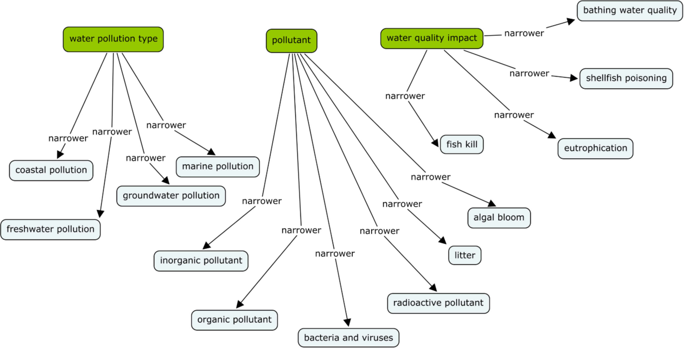
We would like to develop this into a full semantic discovery resource. However, we need local water quality vocabularies or ontologies for us to map. If anybody has these available, please get in touch with BODC. We would also like to hear from anybody interested in working with us to develop semantic resources for Marine Spatial Planning or Climate Risks.
ICAN Cookbooks
Following the ICAN workshop in Copenhagen in 2008, it was decided to provide technical training for costal web atlas developers in the form of cookbooks, especially for people who are starting a new atlas. While the “Coastal Informatics: Web Atlas Design and Implementation” handbook published by IGI-Global in 2011 covers the more theoretical aspects of costal web atlas development, the cookbooks are targeted to contain more practical step-by-step instructions. Consequently, the NETMAR project has produced cookbooks to contribute to this technical training material.
These are:
Understanding Semantics
This cookbook provides a tutorial for those who wish to further investigate and make use of semantic web technologies. For data to be fully understood in a distributed system, they must be labelled (or “marked up”) accordingly. Either the label used throughout the system must use a common set of phrases, or there must be a means of translating between the phrases used at different points of the system. The aim of the cookbook is to provide consistent phrases and to define the relationships in a formal manner, resulting in what is often called a “knowledge organization system”.
In 1999 Tim Berners-Lee wrote “If HTML and the [World Wide] Web made all the online documents look like one huge book, [semantics] will make all the data in the world look like one huge database." The ICAN Understanding Semantics cookbook now provides a tutorial for those who wish to investigate and make use of these technologies, aimed specifically at members of the ICAN community.
Understanding Metadata
This cookbook provides a tutorial for those who wish to better understand metadata. Geospatial metadata is “data about data”. It contains information that documents the basic characteristics of a geospatial data resource. It can also document basic characteristics of geospatial applications or services. Metadata falls into broad categories where it answers the “what, why, when, who, where and how” questions about the resource.
Establishing a CSW metadata catalogue with GeoNetwork opensource
This cookbook provides a tutorial for those who wish to better understand CSW (Catalog Services for the Web) metadata catalogues. It also contains initial pointers to establishing a CSW server using GeoNetwork opensource. A metadata catalogue stores and publishes collections or sets of metadata records describing data, services, and related information resources. Standards are required to enable interoperable searching of distributed metadata catalogues between organisations. This is achieved using the CSW standard
Connecting your Atlas
This cookbook provides a step-by-step guide explaining how to connect a local atlas as a node in the ICAN Prototype and NETMAR Demonstrator. It is a prototype atlas mediator which provides a common interface for accessing distributed local atlases, such as MIDA (Marine Irish Digital Atlas), OCA (Oregon Coastal Atlas), and Washington Coastal Atlas (WCA). It uses a knowledge organization system (KOS) to improve data discovery by exploiting the semantics of keywords and allowing users to search data by “meaning” rather than by “mere keywords.”
The four cookbooks are available in a single PDF file that is currently located at http://netmar.nersc.no/sites/netmar.nersc.no/files/NETMAR_D7.9.1_ICAN_Semantic_Cookbooks.pdf. The NETMAR team plan to update these cookbooks by June 2012. Please get in touch with CMRC if you wish to give us feedback.
ICAN Prototype and NETMAR Demonstrator
The ICAN Prototype and NETMAR Demonstrator provides a graphical user interface which aims to allow users to search data by meaning rather than by mere keywords. Using the ICAN semantic resources it will enable distributed search across local atlases, such as MIDA (Marine Irish Digital Atlas), OCA (Oregon Coastal Atlas), and Washington Coastal Atlas (WCA). The smart search and discovery client currently supports three features: ontology browsing, dataset smart search, and metadata visualisation. Data visualisation and data download are planned.
The search and discovery client helps the user find relevant datasets by allowing him to browse the ontology terms to find suitable search criteria. The ontology browser lists the defined themes, and by clicking on any one of them, their definition is shown along with related terms. From here, the user can inspect any of the related terms by clicking on them, or move on to searching by entering a keyword in the search field. For example, entering “temperature” will search the ontology for any semantically related terms, and display these with definitions inside the browser. When a user has found a suitable search term, he can enter it in the search field at the top of the Ontology Browser window. This will start the dataset smart search application. The search client will present a summary of all datasets matching the criteria, and the user can then click on any of the found datasets to get a full metadata listing for it.
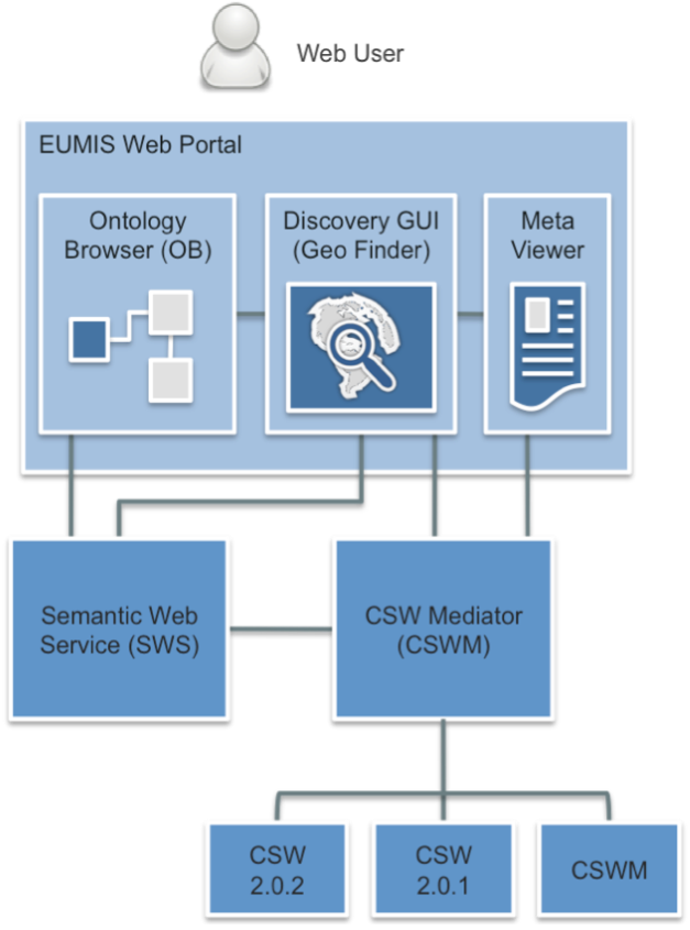
The smart search and discovery client relies on two services: a semantic web service (SWS) and a CSW (Catalogue Service for the Web) mediator (CSWM), as shown in Figure 3. The semantic web service (SWS) provides a high-level interface for retrieving knowledge from the NETMAR ontologies. On top of the catalogue services, a CSW Mediator is responsible for handling metadata semantics and allows data discovery based on semantics.
A test version of the NETMAR Demonstrator is currently located at http://netmar.ucc.ie/discovery/. Please get in touch with CMRC if you wish to connect your atlas to the demonstrator or give feedback.
NETMAR
The Open Service NETwork for MARine Environmental Data is a 3-year project funded by the European Union under its FP7 programme that started in February 2010. The objective is prototype portal development using Liferay technology incorporating tools such as a viewer, semantic resource browser, CSW semantically-mediated search and WPS chain editor as portlets. ICAN was one of four demonstration pilots selected for the project. The work described above would not have been possible without the NETMAR funding.