COINAtlantic introduces Version 2 of its Search Utility
- Details
- Published: 12 March 2013 12 March 2013
Andy Sherin
Director, ACZISC Secretariat
This email address is being protected from spambots. You need JavaScript enabled to view it.
The Atlantic Coastal Zone Information Steering Committee (ACZISC) has released version 2 of the COINAtlantic Search Utility (CSU2). The CSU2 is a web-based tool that searches the internet for spatial data resources that meet the search criteria of the user and enables the user to add the resulting spatial resources to an interactive map (see Figure). The CSU2 uses the Google search API to find spatial data resources in KML or as OGC Web Mapping Services (WMS) and displays the first twenty results for the user to choose from to add to the map. The user can also add a layer to the map from a WMS they know the url for. The CSU2 is customizable taking the default map layers from an editable configuration file. Online mapping is done using the Open Source Geospatial Foundation's OpenLayers Web mapping software.
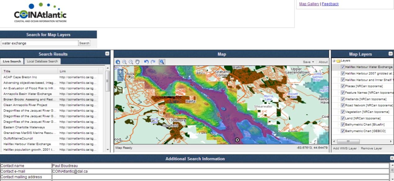
Version 2 replaces COINAtlantic Search Utility Version 1 released in 2008 that relied solely on searching one data base via an API, Canada’s GeoConnections Discovery Portal (GDP). Initially the GDP was intended to grow to be a national repository for metadata, but over the years, organizations developed their own data bases so the GDP focussed mostly on spatial data delivered by one department of the Canadian federal government. This development severely limiting the scope of searches that could be satisfied. CSU2 was designed to bypass accessing individual data bases and use the ubiquitous internet searches to find spatial data resources.
The CSU2 works together with the COINAtlantic GeoContent Generator (CGG), another web-based tool developed by the ACZISC. The CGG enables a user to describe an organization, a project, a report or publication of a data set with basic attribute information (see Table) and link it to a point, line or polygon that describes the spatial extent of the entry. The tool then builds a KML file of the attribute and geographic information and stores it as a file on the ACZISC site and informs the Google search utilities of its location using a Sitemap submission. The CSU2 automatically refers to these files when executing a search.
The user can describe the geography of the entry in the CGG in three ways:
- By hand drawing a point, line or polygon;
- By using one of the polygons from the CGG library of polygons for jurisdictions (e.g. municipal boundaries) and biophysical areas (e.g. watersheds); or
- Uploading an existing KML file from their computer.
Enhancements to the tools are planned. For the CGG, the user friendliness of the interface for the CGG will be improved, the library of KML polygons for users to choose from will be expanded, and the functionality to permit users to edit their own files will be introduced. For the CSU2, the legend functionality will be improved, ways for the user to add WMS layers to the interactive map will be expanded, inclusion of Catalog on the Web (CWS), Web Feature (WFS) and Web Processing (WPS) services will be investigated, and the migration to an open source GIS infrastructure will take place.
The CGG and the CSU2 are available for use and exploration at www.coinatlantic.ca/cgg and www.coinatlantic.ca/csu respectively. The ACZISC Secretariat would appreciate any feedback on your experience using these tools. Please contact us with your comments at This email address is being protected from spambots. You need JavaScript enabled to view it.
| Attribute | Mandatory | Description |
| Type of entry described | Controlled list | Permitted values: an organization, a project, a publication, or a data set. |
| Contact name | Yes | Name of the person making the entry |
| Contact e-mail | Yes | E-mail of above |
| Title | Yes | Short title for the entry |
| Description | Yes | Verbose description of the entry for full text indexing by Google |
| Contact mailing address | No | Mailing address of contact name |
| Geographic location | No | Textual description of the geographic location for the entry |
| Dataset language | No | Language or languages for the entry |
| URL website address | No | The URL of a relevant website e.g. for the organization, etc. |
| URL mapping service | No | If the entry describes an OGC compatible service, the GetCapabilities URL |
| URL standard metadata | No | If standardized (e.g. ISO) and more detailed metadata exists, the URL that provides access to it. |