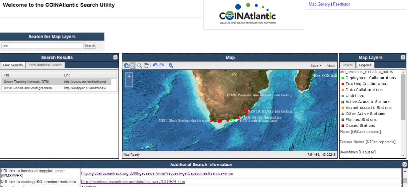
The Atlantic Coastal Zone Information Steering Committee’s (ACZISC) COINAtlantic Search Utility (CSU) has received a number of enhancements. The CSU searches the internet using the Google Custom Search API for web mapping services (WMS) and KML spatial resources that meet the search criteria entered by the user. The user can then chose to add the resulting resources to the map and save the map as an image, pdf or Geotiff.
The CSU enhancements include:
- The speed of loading the application has been improved by reducing the size of Java script libraries;
- A web mapping service can now be added to the map directly from the “URL link to functional mapping server” field found in the metadata display at the bottom of the CSU window (see red box in the figure above for the WMS provided by the Ocean Tracking Network);
- The CSU now uses the GetLegendGraphic feature of the WMS standard to display a legend for an added spatial resource;
- The CSU maintains a local data base of discovered spatial resources that can also be searched using the “Local Database Search” tab. When the “Add WMS layer” feature of the CSU is executed manually by the user, the URL and abstract metadata for the added WMS layer is added to the local database.
Thusly, the local database grows with the use of the CSU, accumulating the results of searches and the manual entries of WMS.
The metadata displayed at the bottom of the figure above was generated by the COINAtlantic GeoContent Generator (CGG), a web-based application, that captures ‘bare bones’ discovery metadata and integrates it with a graphic KML (i.e. point, line, or polygon) that describes the geography the entry is relevant to. The KML can be chosen from a library of KML templates, drawn by hand, or uploaded. The CGG then publishes the KML to the internet and facilitates its discovery by the Google search engine.
Further enhancements are planned including enabling the local database to respond to CSW requests and the CSU search to query CSW-compatible metadata catalogs in addition to the present search of the internet.
The new version of the CSU will be released to coincide with the COINAtlantic Training Workshop to be held on 20 June 2014 just after the Coastal Zone Canada 2014 conference being held in Halifax, Nova Scotia, Canada from 15-19 June 2014. The workshop will not only familiarize participants with the use of the CSU and the CGG, but Jeff McKenna of Gateway Geomatics will take participants ‘under the hood’ and introduce the Open Source components used to build the tools. Follow @coinatlantic for the announcement of the new version of the CSU.