
ICAN - Best Practice Guide to Engage your Coastal Web Atlas User Community
- Detalles
- Publicado: 23 Junio 2017 23 Junio 2017
 ICAN have compiled this best practice user interaction guide because successful interactions with potential Coastal Web Atlas (CWA) users during the development of any CWA are as vital for the success of the resource as the continued interaction with existing audiences to ensure longevity and continued use. This hand book is conceived as a practical “cookbook” and was compiled by gathering information from ten atlas developers as well as extracting relevant information from ICAN workshop reports. The information has been summarised and analysed leading to two sets of recommendations, one focused on the development of new atlases and the other focused on how to maintain interactions with audiences of already developed atlases. We hope that the handbook will allow both new and established CWA developers and hosts to benefit from best practice examples as well as learn from experienced challenges, in order to increase capacity to successfully interact with user communities and target audiences, while managing coastal and marine data and information in a user friendly way. The final product is a resource that hopes to complement and link to a variety of OceanTeacher activities, support IODE training in courses, thereby being of value to all who manage and present marine data and information.
Now available as IOC Manuals and Guides No. 75:
http://www.oceandocs.org/handle/1834/9579
COINAtlantic Announces the Sydney Harbour Atlas
- Detalles
- Publicado: 14 Junio 2017 14 Junio 2017
COINAtlantic has released version 1 of an Atlas for the harbour of Sydney, Nova Scotia, Canada. The Atlas is built on a customized version of COINAtlantic’s Search Utility and displays map layers served from several OGC compliant web mapping services including COINAtlantic’s own WMS service of the data stored in the OBIS Canada Information Publication Tool, and other web mapping services provided by the Province of Nova Scotia and the Government of Canada. The Atlas is intended to display spatial data relevant to an urbanized coastal ecosystem.
The Atlas can viewed at:
http://coinatlantic.tools/csu/?mapset=sydney_harbour
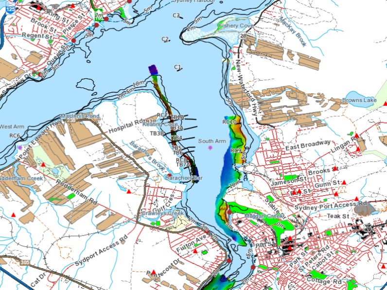
Sample map from the Sydney Harbour Atlas with a partial legend