Marine Environmental Information System for Colombia: first step toward Coastal Atlas
- Details
- Published: 03 March 2014 03 March 2014
Julio Bohórquez, INVEMAR, Colombia. This email address is being protected from spambots. You need JavaScript enabled to view it.
Julián Pizarro, INVEMAR, Colombia, This email address is being protected from spambots. You need JavaScript enabled to view it.
Leonardo Arias, INVEMAR, Colombia, This email address is being protected from spambots. You need JavaScript enabled to view it.
Carolina García Valencia, INVEMAR, Colombia This email address is being protected from spambots. You need JavaScript enabled to view it.
The Marine and Coastal Research Institute (INVEMAR) is linked to Colombian Ministry of Environment and Sustainable Development (MADS) and has the function, among others, to develop technological tools and policy framework which serve to process, store and distribute marine and coastal information required by environmental administration. This information is produced by INVEMAR, MADS, environmental authorities, official coastal entities and marine and coastal research network partners. Since 2000, a technological project called Marine Environmental Information System (SIAM) has met the requirements of the administration and operates the system.
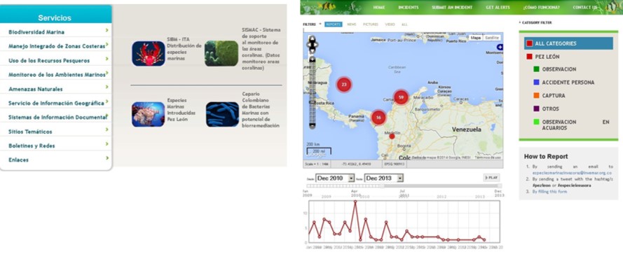
on the left menu to access main components, on the right example of query about invasive specie Lionfish.
This System creates normative tools and administers policies for publication, dissemination, and access to environmental information. Standards are implemented for several processes: ISO19115 for metadata, and OGC standards for online geographic information exchange using services like WMS. Both standards were adopted in coordination with the responsible institute in order to consolidate national efforts aimed to build spatial data infrastructure (ICDE - www.icde.org.co ).
Main Components
The System organizes different issues relevant to marine management as follows:
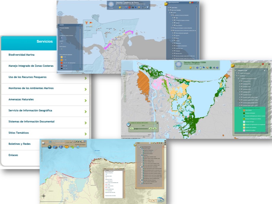
- Biodiversity data, which includes geo-referenced information from biological collections, data from coral reefs, mangroves, and sea grasses monitoring, and tracing reports of invasive species. In the latter case, users have the option of selecting a specific geographic area and receive real time data (Figure 1)
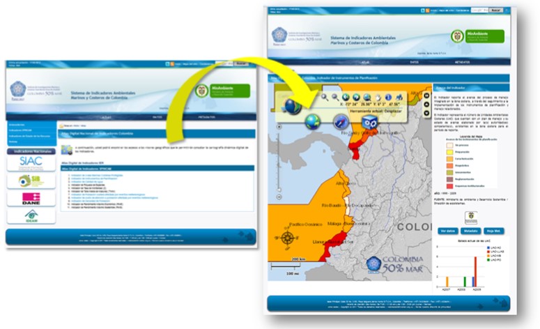
- Laws, programs and research documentation in Integrated Coastal Zone Management, providing a tool to support decision-making in protected areas management context. INVEMAR produces the National Marine and Coastal Environmental Status Report annually, including a Marine Atlas based on indicators. For evaluation and monitoring of the marine and coastal management, the system collects data that together allows calculating environmental sustainability indicators about the state of the environment, existing pressures on resources, and the management actions undertaken by competent authorities. The Indicators meet the needs of decision-makers at national and regional level. In the regional case, for example, the system supports the integrated Coastal Zone Management through the research project "Southeast Pacific data and information network in support to integrated coastal area management" - SPINCAM funded by Flemish Government of Belgium in coordination with IOC-UNESCO, which involves the other four South American countries with coastlines on the Pacific ocean (INVEMAR, 2011) (Figure 2)
- Data from the environmental quality monitoring of coastal waters (REDCAM) and meteorological and oceanographic data are received by telemetry and developed as a climate change adaptation measure which is part of the Integrated National Adaptation Project in a national multi-institutional effort (IDEAM et al., 2011). At present, four weather and oceanographic stations are distributed along the Colombian Caribbean Sea where 15 environmental variables are permanently registered
- Information regarding the vulnerability assessment, mitigation and/or adaptation to natural hazards caused by global climate change and coastal erosion are visualized for information management purposes in tools like CLIMARES and COSTERO
- Geographic information services work as tools that integrate geo-referenced data and show their spatial distribution and its changes in time. Using WMS it is possible to access detailed marine ecosystem cartography information for ecosystems such as coral reefs, mangroves and sea grasses. In addition, users can look up dynamic maps of fisheries and marine protected areas. Other tools complement SIAM services: search within INVEMAR’s specialized marine library, the metadata catalogue, and access to organized information in thematic websites (Figure 3)
SIAM components are developed in different technological degrees to offer several online services in order to: enhance services associated with the ocean observation systems and the coastal erosion system, redesign biodiversity monitoring in order to have a better selection of spatial services, and implement a geo-database that corresponds to coastal marine model. With a constantly growing database and datasheets of more than 10 years, the medium term goal is to develop web services with higher benefit, supported on data mining technology and research oriented to geoprocessing.
Several software packages support SIAM’s infrastructure. Among the most relevant are: ORACLE for database management, ESRI tools for the development and deployment of geographic information, GeoNetwork for metadata catalogue, and ALFRESCO for documents management. INVEMAR has its own system information department: the Information Systems Laboratory comprised of a group of specialized researchers trained in software development, remote sensing information analysis tools, and GIS technologies in general.
The system serves as a technological tool to support knowledge generation activities in marine and coastal issues. Any group that requires technology for data management can use the existing infrastructure following agreement between the parties. The main users of SIAM services are researchers and students of marine sciences that look for the understanding of the dynamics of the physical, biological and social marine processes. Also, government members can benefit of the system for environmental management and decision-making.
The information contained has supported publishing the first Marine, Coastal and Continental Ecosystems Map in Colombia (IDEAM et al., 2007) at 1:500.000 scale. In addition, there are several other examples of its use: - Evaluation, implementation and control measures to ensure the sanitary quality of the tourist beaches, using REDCAM services, reports, indicators and map viewer. The main users are regional environmental authorities. - The design and management of marine protected areas (Decision support system for the Sub-system of Marine Protected Areas and Biodiversity system). The main user is Colombian’s Department of National Parks. - Activities that demand environmental licenses, permits, concessions or authorizations. The system contains the official cartography of marine and coastal ecosystems (coral reefs, sea grasses, mangrove, soft bottoms and beaches) of the country. - Evaluation of possible compensation for the execution of mineral exploration activities (map viewer of fishing grounds), the main user is the National Hydrocarbons Agency.
Bibliography
- IDEAM, IGAC, IAvH, INVEMAR, I. SINCHOi e IIAP. 2007. Ecosistemas continentales, costeros y marinos de Colombia. Instituto de Hidrología, Meteorología y Estudios Ambientales, Instituto Geográfico Agustín Codazzi, Instituto de Investigación de Recursos Biológicos Alexander von Humboldt, Instituto de Investigaciones Ambientales del Pacífico Jhon von Neumann, Instituto de Investigaciones Marinas y Costeras José Benito Vives De Andréis e Instituto Amazónico de Investigaciones Científicas Sinchi. Bogotá, D. C, 276 p. + 37 hojas cartográficas. Download full document in: http://www.invemar.org.co/noticias.jsp?id=3458
- IDEAM, INVEMAR, CORALINA, INS, CI. 2011. Presentación resultados del proyecto INAP (donación TF056350). Informe Final. Instituto de Hidrología, Meteorología y Estudios Ambientales, Instituto de Investigaciones Marinas y Costeras José Benito Vives De Andréis, Corporación para el Desarrollo Sostenible del Archipiélago de San Andrés, Providencia y Santa Catalina, Instituto Nacional de Salud, Conservación Internacional. Bogotá, D. C, 122p http://bit.ly/1lCtwZm
- INVEMAR, 2011. Red de Información y Datos del Pacífico sudeste para el apoyo a la gestión integrada del Área Costera SPINCAM Colombia. Informe Técnico Final CPPS Fase I – Punto Focal Nacional Ministerio de Ambiente y Desarrollo Sostenible, Santa Marta, Editado por: Lozano-Rivera P., Arias-Alemán, L.J y Sierra-Correa, P. 39p.+ Anexos http://bit.ly/1orc9wy