These notes were transcribed after the event, and key points are:
Highlights from the mini-Workshop Breakout Groups
 A Coastal Atlas is a portal to understanding that provides:
- insights into nature
- understanding of the interaction of processes
- democratic access to information
- ability to participate in conversations
- highlight the importance of the coast for decision makers
Coastal Atlases could potentially provide:
- Open access to data
- Information about
- economic value of coasts
- ecosystem services
- human uses and intensity
- climate change, future mitigation
- land loss due to sea level rise
- indigenous / cultural community impacts
- Access to crowd-sourced information based on citizen observations
- Tools to “make your own” version
- Improved use of indicators
- Priority to local approaches
- Mobile friendly / compatible applications
ICAN should have:
- Provide more comprehensive coverage
- Access to guidance and best practices for Atlases
- Access to information about Coastal Atlases worldwide and the information they contain
- Consider minimum atlas pages for not yet participatory countries (e.g. via OBIS)
- Opportunities for non-coastal countries, especially those with watersheds that contribute plastics
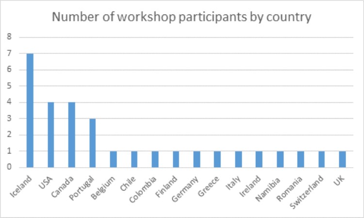
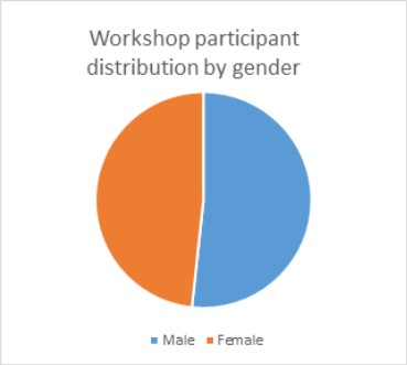
We had approximately 30 participants from 16 countries, and participants were surveyed both before and after the event to gauge their reaction to, and perception of the topics and approach. Overall, reactions from participants were positive regarding the group break out approach, and participants reported increased knowledge about ICAN, the UN Ocean Decade of Science, and the SDGs after the conclusion of the event. Presentations are posted on the ICAN website.