
Overview of the Caribbean Marine Atlas
- Detalles
- Publicado: 04 Marzo 2012 04 Marzo 2012
The Caribbean Marine Atlas (CMA) is a regional project involving several countries within the Wider Caribbean Basin in a joint effort to promote sound decision-making through access to high-quality coastal and marine spatial information. The purpose of the CMA is to identify, collect and organize available spatial datasets into an atlas of environmental themes for the Caribbean region. The project is currently under the sponsorship of the Intergovernmental Oceanographic Commission's (IOC) International Oceanographic Data and Information Exchange (IODE) and Integrated Coastal Area Management (ICAM) Programmes. The embodiment of the goal of the project is an online mapping and data management application available to environmental managers and other users both within and outside of the Wider Caribbean Region.
In addition, using the skills obtained through the capacity building component of the CMA project, participating countries are in the process of developing national marine atlases based on the structure and functionality of the regional atlas but focused on the national coastal/marine area management priorities of the respective states. Thus the CMA will, through its products and services available at the national level, directly contribute to the sustainable development and integrated management of marine and coastal areas in the region.
All programme activities under the project have been developed and conducted with the above factors as their raison d’être. As a result the CMA programme has the potential to be one of the most significant recent advancements in coastal area management through the development of tools and processes which promote actual fact-based decision making.
Accomplishments
The CMA project is currently in its second phase which began in late 2009 and has already achieved many of its primary goals. These include capacity building within the sphere of marine data management, the production of developer and user resource materials for CMA technologies, and the development of a basic web-based mapping application. Specific achievements and/or activities under these project areas are outlined below.
Capacity Building
A network of Caribbean data managers benefitted from IODE training courses in ocean data management, data mining and web atlas development conducted during phase 1 of the CMA.
Specific training was given for atlas developers via the CMA Training Course on PostgreSQL, PostGIS and OpenLayers for Web-Based Atlas Development in Bridgetown, Barbados in April of 2011.
The development of web-based mapping applications has resulted in the exposure to and growing familiarity with several coding languages (Javascript, PHP, HTML, XML) and software platforms (GeoServer, GeoNetwork).
Development of Resource Materials
The main CMA website www.caribbeanmarineatlas.net is host to information on all of the training courses, planning meetings and national stakeholder meetings conducted as part of the CMA project.
A user manual for the mapping application has been developed and is also available on the main site
Resource materials directly related to national atlas development efforts and other developer-specific materials are available in a section of the main website not open to the general public.
Mapping Application Development
The CMA mapping application has been constructed from three components:
The web map server (GeoServer) http://geonetwork.iode.org/geoserver/web/ hosts the data available under the CMA project (and other IODE projects), publishes the data as a web map service (WMS) for use by the CMA mapping application, but also for any interested party.
The metadata catalog for CMA data (GeoNetwork) http://geonetwork.iode.org/geonetworkCMA/srv/en/main.home hosts the metadata information associated with published CMA datasets, allows users to search for datasets (and any other spatially enabled content) by geographic area.
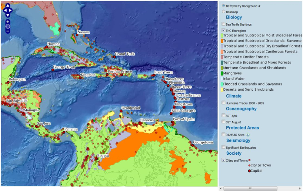
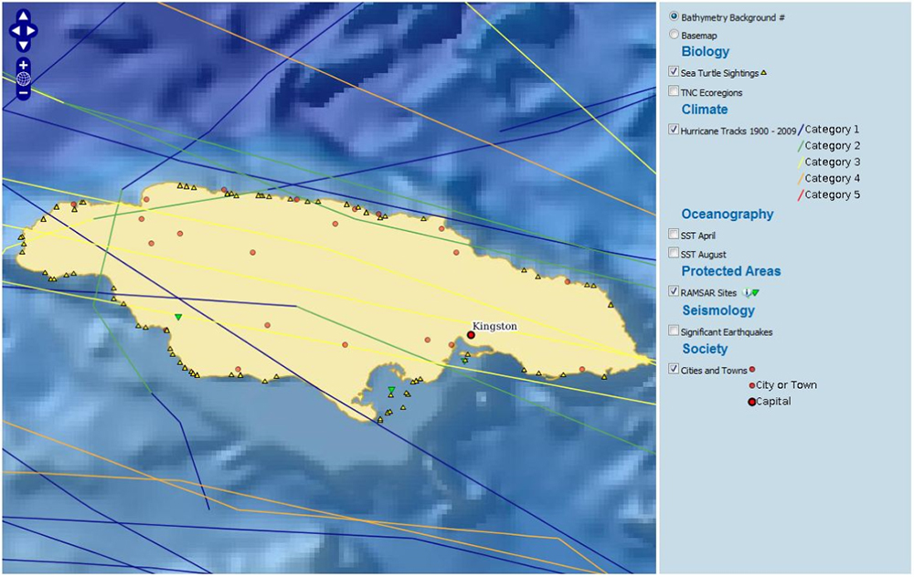
The mapping application user interface (accessible via the Map Page tab on the main CMA site) allows users basic GIS control over available spatial datasets including query functionality, legends and links to metadata records.
Current Status of the CMA Project
There are several activities relating to the development of both the regional atlas and national atlases are currently being conducted, including:
- The development of a code template for national atlases,
- Improving the functionality of the regional atlas,
- Formatting and uploading additional datasets, and
- Data gathering for national atlas development projects.
Future of the project
Between 2012 and 2013, several activities are expected to be completed to fulfill the goals of the CMA project, these include:
- The rollout of several national coastal/marine atlases based on the CMA,
- Additional national stakeholder meetings,
- The improvement of functionality for both national and regional atlases,
- Atlas user and developer training,
- National-level atlas promotion, and
- The development of an atlas sustainability strategy