New Alaska Shoreline Change Tool
- Detalles
- Publicado: 08 Marzo 2015 08 Marzo 2015
Many coastal communities in Alaska are vulnerable to erosion and lack shoreline change data to perform accurate assessments of this coastal hazard. To address this issue, the Alaska Division of Geological & Geophysical Surveys (DGGS) has developed an interactive map tool that displays historic and projected shoreline positions. This web atlas will improve vulnerability assessments and long-term management approaches for coastal communities throughout the state by enabling access and visualization of trends in shoreline position.
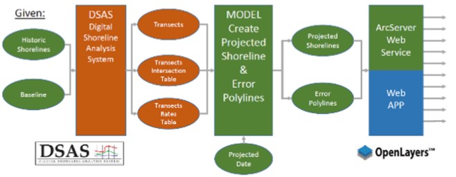
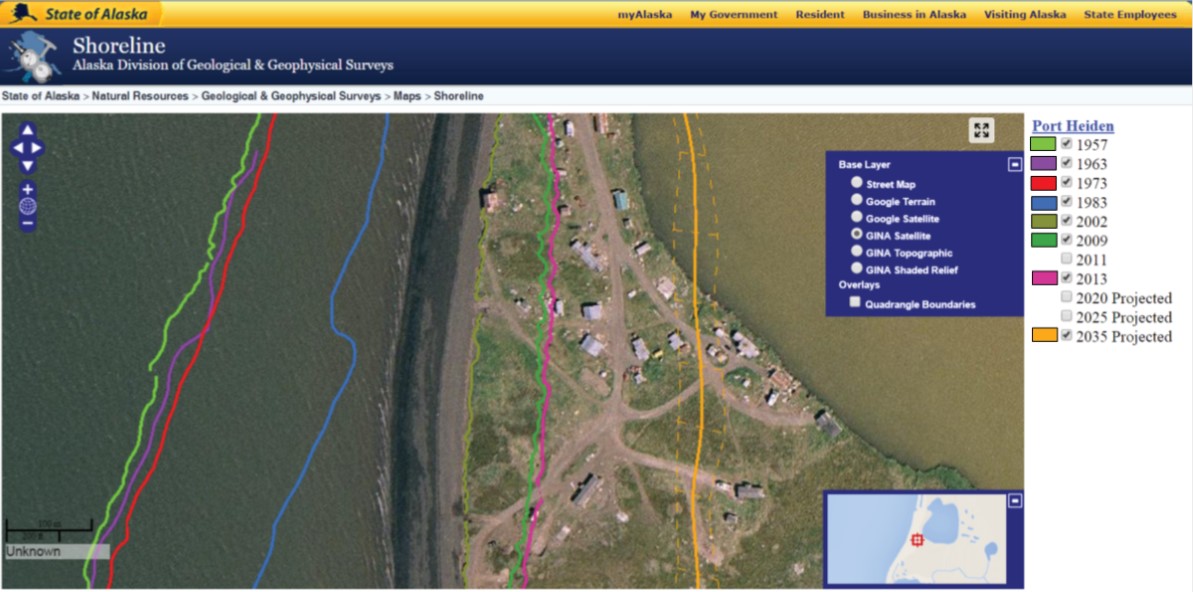
Historic shoreline positions in the database are derived from a range of remote sensing techniques in combination with field campaigns. The U.S. Geological Survey Digital Shoreline Analysis System (DSAS) is used to calculate rates of shoreline change, and DGGS staff have built a GIS model that extrapolates these rates of shoreline change to illustrate a projected future shoreline position (Figure 1). This model incorporates errors from the DSAS calculations, which are presented as a confidence interval surrounding the predicted shoreline (Figure 2).
Local officials are already using this tool to make more informed decisions about the managed retreat of critical infrastructure.
The dashed orange lines represent the 2035 projected shoreline uncertainty
Although this tool presents simplistic linear trends, it serves as a valuable improvement to existing resources in Alaska for identifying, prioritizing, and planning for statewide coastal erosion issues. To help educate stakeholders about the uses and limitations of these types of analyses, DGGS staff are teaming up with science illustrators from the University of Alaska Fairbanks to prepare a comprehensive companion document and the live release of this web atlas is scheduled for April 2015.
ICAN Activities Endorsed by IODE Committee
- Detalles
- Publicado: 05 Marzo 2015 05 Marzo 2015
ICAN Steering Group members Ned Dwyer, Dawn Wright, Lucy Scott and Linda Pikula demonstrated the strong commitment of ICAN to IODE at the IODE-XXIII meeting held from 17-20 March 2015 in Bruges, Belgium. This biannual meeting was attended by representatives of all IODE projects, delegates from the National Oceanographic Data Centres of IOC member countries and observer projects. The proposed ICAN work plan and budget proposal for 2016-2017 was accepted by the Committee underlining that ICAN activities are of great relevance to IODE members.
Other IODE projects presented during the meeting and of particular interest to ICAN include OceanDocs and Ocean Data Practices. OceanDocs (http://www.oceandocs.org/) is an e-repository of scientific publications related to marine science and oceanography which ICAN should take advantage of for its own holdings. The Ocean Data Practices service (http://www.oceandatapractices.net/) which is aimed at promoting the use of common methodologies in ocean data and information management and improved interoperability between these systems could also be a mechanism ICAN could use to disseminate its own best-practice guides.
- The ICAN plan and budget is available at:
http://www.iode.org/index.php?option=com_oe&task=viewDocumentRecord&docID=14496 - The full report from the IODE-XXIII meeting is available at:
http://www.iode.org/index.php?option=com_oe&task=viewDocumentRecord&docID=14791