
Washington Coastal Atlas Continues Upgrade
- Detalles
- Publicado: 07 Septiembre 2012 07 Septiembre 2012
Liz O’Dea
Washington State Department of Ecology
Esta dirección de correo electrónico está siendo protegida contra los robots de spam. Necesita tener JavaScript habilitado para poder verlo.
The Washington Coastal Atlas (https://fortress.wa.gov/ecy/coastalatlas/) team has completed phase two of its three-phase redesign project. In addition to its new look and feel, the atlas now has four use-specific tools that users can access directly from the home page.
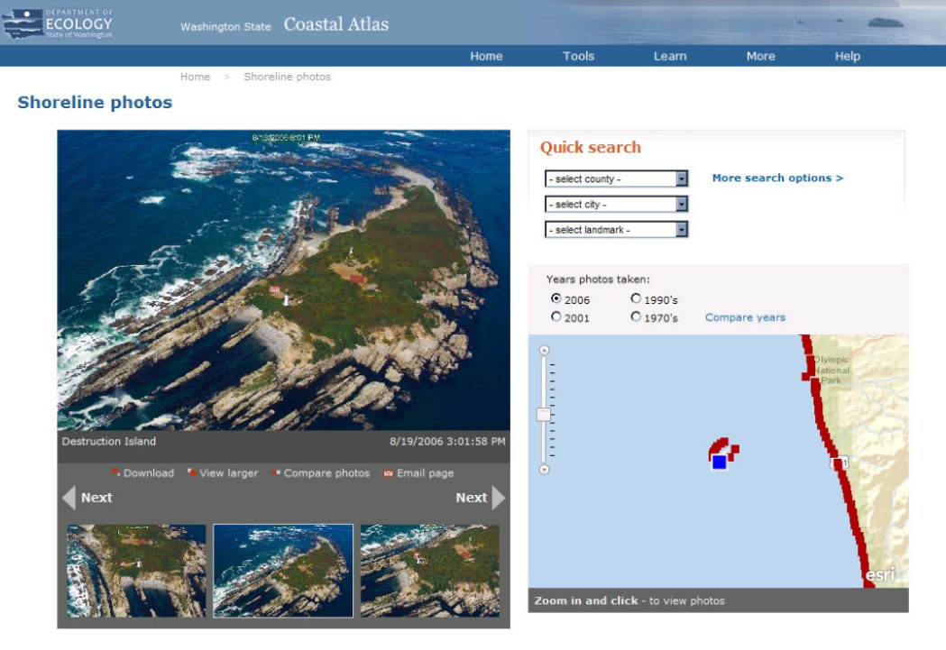
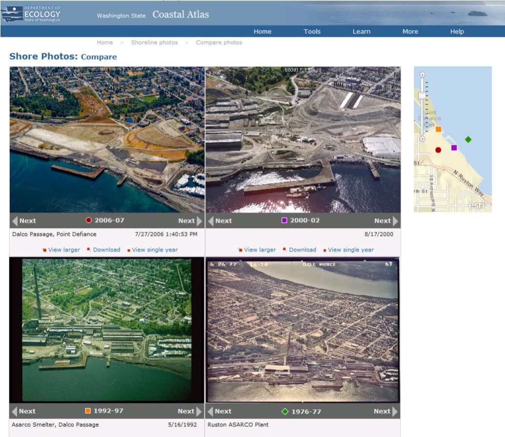
Shoreline Photos: The Washington Department of Ecology’s oblique photo time series of Washington’s marine and freshwater shorelines has been the most widely used component of the Coastal Atlas over the years. The new Shoreline Photo viewer improves the ease of finding a photo for a specific area from multiple time periods. The viewer enables users to quickly navigate through images along a shoreline and simultaneously see the location on a map. It also provides a comparison page, where users can view the same area over time from the collection of years. Each year’s photos can be independently navigated so that the user can choose the images that allow the best shoreline comparison.
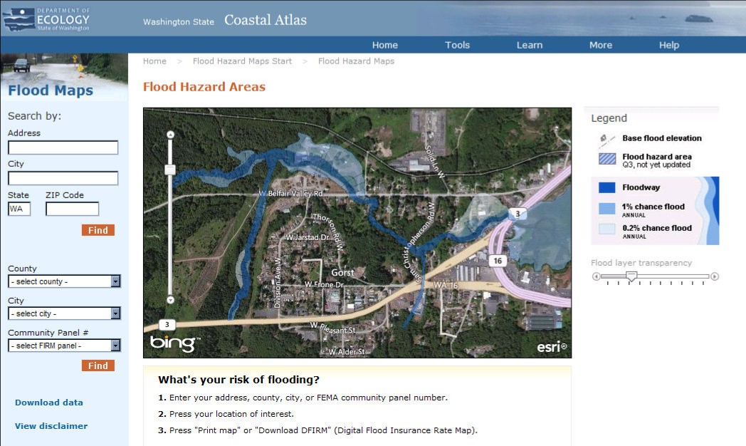
Flood Hazard Maps: A new viewer for FEMA flood maps makes Digital Flood Insurance Rate maps downloadable directly from the Coastal Atlas, which helps inform real estate decisions and transactions. The ability to view flood maps superimposed on aerial photography helps people better understand flood issues within the context of the landscape.
Public Beach Access: Public access is only available on about 30% of Washington’s marine shorelines, and the public’s right to access the shoreline is one of the three pillar policies of Washington’s Shoreline Management Act. We have made it easier for people to discover where they can access the shore. People can find beaches by name, location, or by specific amenities or activities. Beach information includes photos, amenities, directions, and links to tides, weather, and local information sources.
Beach Closures: Users can also find beach closure information and monitoring results for all locations monitored by the Dept. of Ecology/Dept. of Health BEACH program.
Former Washington Coastal Atlas Manager and ICAN member Kathy Taylor has transitioned to another position in the Department of Ecology. She was a wonderful leader who guided us through the first two redevelopment phases, and was a strong cheerleader on the value of the Washington Coastal Atlas for the people of Washington State. Her replacement, Brian Lynn, has been involved with the Coastal Atlas for many years and leads us forward through our third phase of redevelopment: migrating the Washington Coastal Atlas Map from ArcIMS to ArcGIS Server using the JavaScript API, including a new interface design. This is due to go live in November.
Regional Data Management and Portal Design Workshop / New Marine Planning Listserv
- Detalles
- Publicado: 05 Septiembre 2012 05 Septiembre 2012
Adam Bode
NOAA Coastal Services Center
Esta dirección de correo electrónico está siendo protegida contra los robots de spam. Necesita tener JavaScript habilitado para poder verlo.
The NOAA Coastal Services Center hosted a Regional Data Management and Portal Development Workshop in Charleston, SC on June 27-28, 2012. The objectives of the workshop were to build awareness among participants of the status of existing regional and national marine information systems; develop strategies for integration of national and regional coastal and marine data and systems-related activities; identify common data management and exchange standards and procedures; and identify methods to increase collaboration among marine data management groups. The workshop report can be found here: link
Based on feedback received during this workshop, the ocean.data.gov team recently created the Marine Planning Portal Network listserv, which will serve as one of the main conduits for communication between state, regional, and national portals, applications, and planning efforts. As systems become more distributed and technology continues to evolve, the need to share information (lessons-learned, best practices, etc) and provide a venue for open dialogue is paramount. This listserv is designed to serve this purpose. If you are interested in joining the listserv, please visit the following link to register - link
In addition to the listserv, the following ideas have been discussed to help spark engagement and continue the discussions from the Workshop:
- Webinar Series - The frequency of these is still to be determined but the initial thought is to have them every other month, focused on the following
- Round Robin Updates - Short updates on the current status of state, regional, and national efforts. Used for quick information sharing and also to spark interest in technical topics, issues, or additional discussion
- Featured Presentation – In-depth presentations/demonstrations of existing products or beta releases
- Technical / Topical Discussions – Based on the input from the Network, these could focus on a certain technical issue, topic, or discussion point. For instance, this could be the start of a discussion on a Network-wide metadata strategy.
- GeoTools Conference Tools Showcase - Similar to the Map Gallery at the ESRI UC, this is an informal opportunity to present/demo your tool and application. A dedicated space may be available to highlight the various state, regional, and national applications and portals.
- Oral Presentation - Based on interest, there may be a track or session dedicated to Regional Data Management and/or Portal Design.
- Informal Network Lunch/Happy Hour - Lastly, there are plans to re-design the Technical Community of Practice (link) within the Ocean Community to serve as a landing page for this Network. The new webpage will more effectively provide access to the best practices and resources most relevant to your efforts and serve as a location where a variety of information relevant to this Network can be accessed.