
ICAN CWA User Interaction Guide
- Detalles
- Publicado: 16 Febrero 2017 16 Febrero 2017
ICAN is very pleased to announce that "ICAN - Best Practice Guide to Engage your Coastal Web Atlas User Community" is now available as IOC Manuals and Guides No. 75
We have compiled this best practice user interaction guide because successful interactions with potential Coastal Web Atlas (CWA) users during the development of any CWA are as vital for the success of the resource as the continued interaction with existing audiences to ensure longevity and continued use. This hand book is conceived as a practical “cookbook” and was compiled by gathering information from ten atlas developers as well as extracting relevant information from ICAN workshop reports. The information has been summarised and analysed leading to two sets of recommendations, one focused on the development of new atlases and the other focused on how to maintain interactions with audiences of already developed atlases. We hope that the handbook will therefore allow both new and established CWA developers and hosts to benefit from best practice examples as well as learn from experienced challenges, in order to increase capacity to successfully interact with user communities and target audiences, while managing coastal and marine data and information in a user friendly way. The final product is a resource that hopes to complement and link to a variety of OceanTeacher activities, support IODE training in courses, thereby being of value to all who manage and present marine data and information.
National Coastal and Marine Atlas for the South Pacific Zone of Panama
- Detalles
- Publicado: 20 Noviembre 2016 20 Noviembre 2016
Luz Guerrero Robles
Aquatic Resources Authority of Panama
Ricardo de Ycaza
Ministry of Environment of Panama The Panamanian Aquatic Resources Authority (ARAP) and the Ministry of Environment of Panama have been involved in the SPINCAM project since 2009 and worked on the basis of measurable indicators over time.
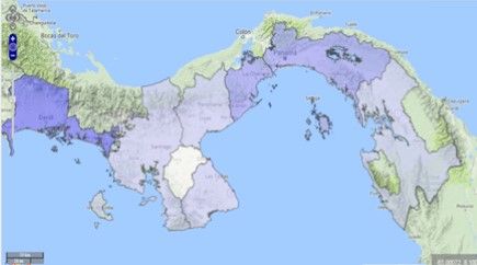
The National Coastal and Marine Atlas for the South Pacific Zone of Panama was generated as a technical and integral information repository, which serves as an instrument to support marine-coastal management and planning initiatives. It was designed under the National Cartographic Base rules at a scale of 1:250,000 whose information is stored in geographic coordinates (WGS 84 Reference System).
The National Coastal and Marine Atlas for the South Pacific Zone of Panama is a basic tool accessible by public managers for the diagnosis, detection of threats, hazards, vulnerability and risks focus towards coastal and marine management and planning. This analysis tool will help to identify the feasible zones of the country for conservation and protection according to technical, environmental and social criteria.
The National Atlas contains a number of coastal indicators related to coastal economy, population density, marine protected areas, coastal concession, population dynamics, water quality, fisheries, coastal ecosystems, all fully sustainable and measurable.
The fisheries indicator, for example, has served as an operational tool in fisheries management for national authorities.
It integrates information on catches, landing and fishing effort to determine the area with the highest concentration of marine coastal species in order to design fishing management strategies based on this indicator.
On the other hand, the national atlas also includes a detailed indicator on coastal population density. The distribution of coastal human population indicates that the concentration of almost half of the country’s population inhabits the coastal zones of Panama. This shows the increasing pressures on coastal ecosystems and services which has an amplified effect due to the disordered occupation of the land, therefore, increasing the risk of coastal degradation.
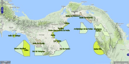
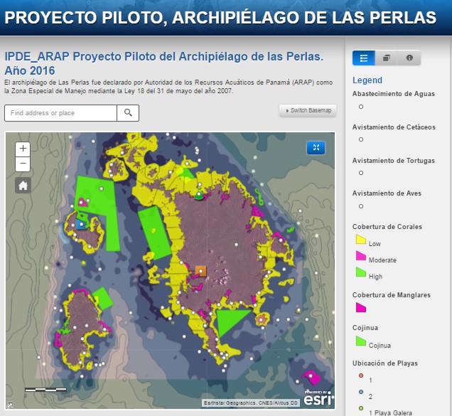
The National Atlas also includes a local pilot project called “The Coastal and Marine Atlas for the Archipelago of Las Perlas”. The Special Management Zone (ZEM) of the Las Perlas Archipelago, located in the district of Balboa, province of Panama, was created with the purpose to protect marine-coastal resources, increase productivity and maintain the biodiversity of their ecosystems, in the neighboring area of the Panama Canal.
Thirteen (13) indicators were defined and integrated in the Coastal and Marine Atlas for Las Perlas which will be used to guide local decision makers, communities and other regions of Panama.
Finally, the increasing alteration and degradation towards coastal and marine resources is leading to revaluate community agreements, laws and regulatory framework in order to protect the ecosystems, implementing the use of the fishing and marine resources considering their limitations, and to work on the concept of Marine spatial planning.
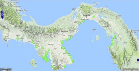
Over twenty layers are represented on the map. Only part of the legend is shown
http://geored.maps.arcgis.com/apps/PublicGallery/map.html?appid=1be3830071d74ec98c33147cfc301fac&webmap=a532b3de81ac4576a70aa8a7cefc3f63