
Ohio Coastal Atlas enters Third Edition
- Detalles
- Publicado: 05 Noviembre 2016 05 Noviembre 2016
Brian D. George
Ohio Department of Natural Resources
Office of Coastal Management
Esta dirección de correo electrónico está siendo protegida contra los robots de spam. Necesita tener JavaScript habilitado para poder verlo.
The Ohio Department of Natural Resources Office of Coastal Management coastal.ohiodnr.gov is currently developing a Third Edition of its Ohio Coastal Atlas. The new Coastal Atlas publication is expected to be completed in late 2017. It will be a 10-year update and will correspond with the Ohio Coastal Management Program’s 20th anniversary.
The widely-successful, 240-page Second Edition (2007) featured 13 chapters and highlighted content that focused on the cultural, ecological, physical and natural resources in Ohio’s Lake Erie basin. It was distributed primarily to coastal decision-makers, local officials, land use planners, coastal engineers, environmental groups, educators and other special interest groups. The forthcoming Third Edition will incorporate updated and newly-acquired GIS datasets, feature new topics of interest, and include all new maps using enhanced cartographic techniques.
The Ohio Coastal Atlas aims to spatially represent big-picture information and topics about Ohio’s portion of Lake Erie and its watershed. Development of the Atlas is a collaborative effort involving many federal, state and local partners.
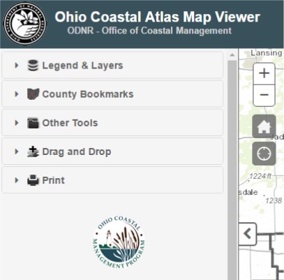
The interactive map viewer for the Ohio Coastal Atlas can be found at: https://gis.ohiodnr.gov/MapViewer/?config=interactiveatlas
Caribbean Marine Atlas enters Phase 2
- Detalles
- Publicado: 01 Noviembre 2016 01 Noviembre 2016
Leonardo Arias, Carolina García-Valencia,
Paula Cristina Sierra-Correa, and
Francisco Arias
Marine and Coastal Research Institute INVEMAR. Colombia
Critical ecosystem goods and services provided by the marine environment in the Caribbean are at risk from threats including weak governance, mismanagement, climate change and the inadequate availability and incorporation of data and information in decision-making. The Caribbean Marine Atlas Phase 2 – CMA2 is working on spatial-based technological solutions in support of Integrated Coastal Zone Management (ICZM) and the Caribbean Large Marine Ecosystem Project (CLME) and related decision-making, monitoring & evaluation processes for the Region.
The general objective of CMA2 is sustainable operationalization of an online digital “Caribbean Marine Atlas” technology platform in support of ICZM (with special attention to: coastal hazards, climate change, biodiversity & habitats, fisheries, and land-based sources of pollution) and ecosystem-based management for CLME.
This objective will be achieved by:
- Providing and operating an information discovery, Decision-Support (DS)/Monitoring & Evaluation (M&E) mechanism for improved Integrated Coastal Zone Management (ICZM), in at least 7 pilot countries, based on state-of-the-art technology for the online publication, management and exchange of spatial data/information layers and ICZM best practices/tools.
- Contributing with the DS/M&E mechanisms at Caribbean Large Marine Ecosystem level through join efforts with CLME.
- Enhancing awareness, capacity and participation of key regional and national level stakeholders (both data users and data providers) in the development and use of the information discovery, DS and M&E mechanisms (with special attention to long-term sustainability, and further up-scaling of CMA2 Project results).
- Providing mechanisms for seeking and acting on feedback to encourage both partners and stakeholders involvement with project milestone events, activities and results, based on the communication plan.
The CMA2 platform will contribute to better governance by the reduction of the vulnerability of coastal socio-ecological systems in Caribbean States, allowing decision makers faster access to timely data, geospatial services and applications; using processes and shared infrastructure leading to optimization of the information exchange between participants, permitting reuse as well as the adaptation of geospatial resources for the consolidation of a permanent query tool.
BACKGROUND
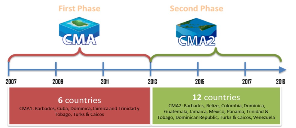
First Phase (2007-2013)
The Phase 1 of CMA is a joint project of Caribbean countries Barbados, Cuba, Dominica, Jamaica, Trinidad and Tobago, Turks and Caicos, aimed at providing high quality geospatial data and information related to the marine and coastal zones of the states. The purpose of the CMA1 was to identify, collect and organize available geo-spatial datasets into an atlas of environmental themes for the Caribbean region as a support service to the sustainable development and integrated management of marine and coastal areas of the region. The CMA1 was inspired by the African Marine Atlas project http://www.africanmarineatlas.org
Second Phase (2013-2017)
The CMA2 project, in contrast to CMA1, involved a much large group was invited for the project resulting in 12 participants. They included the national partners Barbados, Belize, Colombia, Dominica, Guatemala, Jamaica, Mexico, Panama, Trinidad & Tobago, Dominican Republic, Turks & Caicos and Venezuela (Figure 1).
The proposed project will identify the specific, policy-relevant coastal / marine data and information outputs needed across the Region, and develop tools and applications to manage, analyses, produce and publish these outputs. The CMA2 project builds upon the experience and lessons learned in the CMA1, Ocean Data and Information Network the Caribbean and South America (ODINCARSA) and Southeast Pacific Data and Information Network in support of Integrated Coastal Area Management (SPINCAM I & II). CMA2 will form an alliance with SPINCAM for indicators, carry out “twining activities”, as well as use a handbook for measuring the progress and outcomes of Integrated Coastal and Ocean Management written by the Intergovernmental Oceanographic Commission (IOC).
The project is implemented through the IODE/IOC/UNESCO with the financial support of the Government of Flanders and the regional coordination by the Marine and Coastal Research Institute (INVEMAR).
ADVANCES
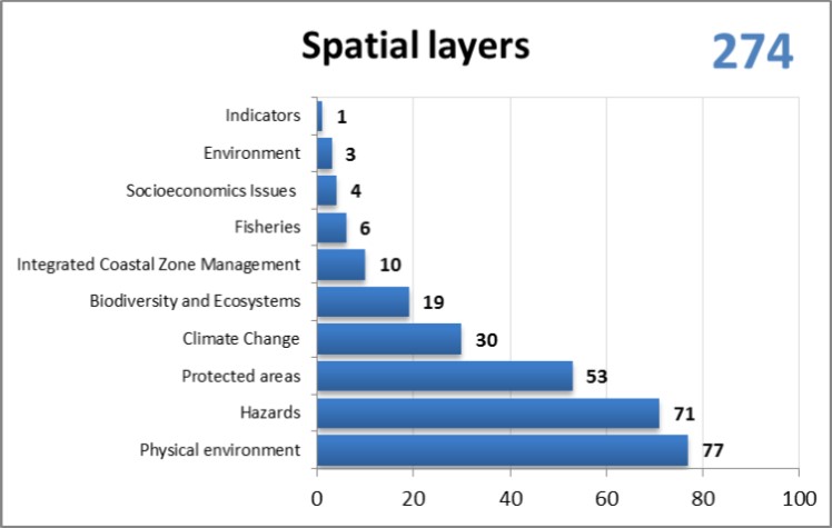
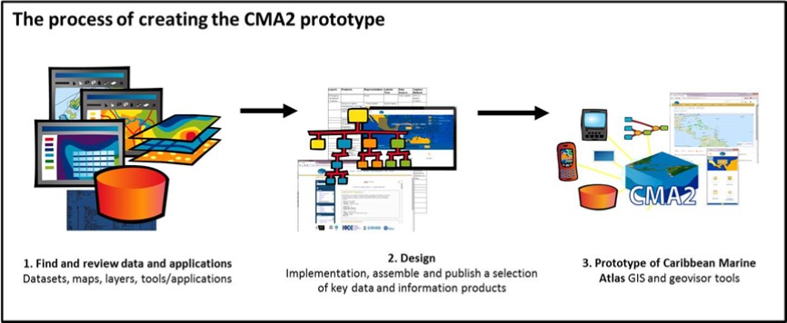
The development of CMA2 started with a detailed work plan definition, followed by a work team consolidation and the identification of stakeholders in the Caribbean region. A review of the state of art of the Coastal Marine Atlas was made. The information was organized to take inventory of spatial information and technology platforms available to Global, Regional and Local (National) levels (Figure 2).
Geonode v4 and its technology was selected to meet the characteristics and technical specifications required for this project. The CMA2 team is working on a prototype of the Caribbean Marine Atlas with GIS and Geoviewer tools (Figure 3) available at www.caribbeanmarineatlas.net
Within the framework of CMA2, fulfilling its objective of contributing to a better integrated management of coastal zones, the implementation of indicators are proposed that help decision making. The Caribbean Region, despite great diversity amongst the countries that comprise it, have problems and issues that are common. This makes necessary the careful design of a range of indicators which are specific, measurable, attainable, relevant and measurable over time; to assist decision-making and management of coastal areas, not only doing it efficiently, but also sustainably and sensitively to the needs of the coastal population. At this stage, the project has proposed an initial battery of 10 indicators, the ultimate goal of these indicators is to generate information that will allow the comparison of the state of different situations common to the countries of the Caribbean, to contribute to the work in the countries of the Caribbean team and provide solutions to problems that exist in the region. The CMA2 team is working on methodologies and search and selection of data sources in each country.
ACHIEVEMENTS
- The project has an operational technological platform active on GeoNode with 178 layers, 7 maps, 35 users, 10 documents, calendar and news.
Eleven country partners (9 officially committed) - Ten indicators developing (each country leads one indicator) (sea level change, coral health, protected coastal and marine area, fisheries total catch by country, frequency, magnitude and assessment of impact of natural disasters, occurrence of anomalies on sea surface temperature, invasive species and threatened species, coastal economic activities, coastal population density)
- Two training courses with 40 participants from 9 different Caribbean countries (ICZM and Marine GIS) for capacity building
- A communication plan developed and running: teleconferences, meetings and two national technical visits to Guatemala and the Dominican Republic to support national processes).
- Presentation at congresses (Gestão Integrada de Áreas Litorais (GIAL) 2016 and IAMSLIC 2016)
Join us http://www.caribbeanmarineatlas.net or more information on CMA2, contact to Paula Sierra-Correa Esta dirección de correo electrónico está siendo protegida contra los robots de spam. Necesita tener JavaScript habilitado para poder verlo. or Carolina García-Valencia Esta dirección de correo electrónico está siendo protegida contra los robots de spam. Necesita tener JavaScript habilitado para poder verlo.