
News
Maryland Launches Coastal Atlas 2.0
- Detalles
- Categoría: News News
Maryland’s Coastal Atlas is an online mapping and planning tool that allows state and local decision-makers to explore and analyze data for coastal and ocean planning activities. In January 2015 the Maryland Department of Natural Resources’ Chesapeake and Coastal Service updated Maryland's Coastal Atlas to Version 2.0.
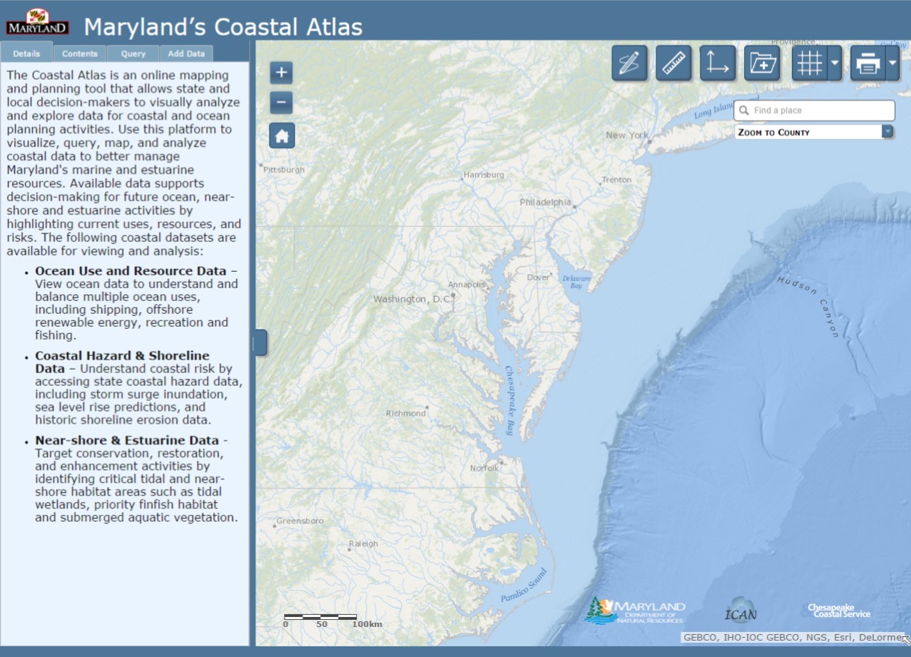
The Coastal Atlas provides access to data on physical characteristics, human uses, and ecological resources for our ocean, shoreline, near-shore, and estuarine areas. Datasets are provided by a number of partners, including Maryland Department of Natural Resources, the Maryland Energy Administration, Towson University, the University of Maryland, The Nature Conservancy, the Mid Atlantic Regional Council on the Ocean (MARCO), and the National Oceanic and Atmospheric Administration. In addition to coastal datasets, online tools have been developed to support better decision-making and help concerned citizens address specific coastal issues.
 Chesapeake and Coastal Service staff worked in concert with our Geospatial Analysis and Targeting Division and staff from Maryland’s Department of Information Technology to update the Coastal Atlas and prepare it for the coinciding 1 January 2015 launch of MD iMap 2.0. A new MD iMap 2.0 web template provides Maryland’s abundant state mapping tools and services with a consistent design and provides a more user-friendly environment .
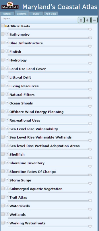
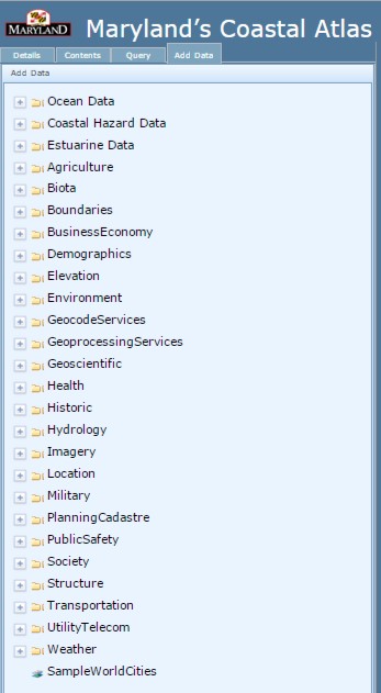
Besides the fresh look and larger mapping area, one of the most noteworthy changes to the Coastal Atlas is the location and organization of the data layers. Coastal Atlas data is no longer separated into individual thematic mappers (Ocean, Estuaries, and Shorelines). All State coastal data is now organized alphabetically along the left menu bar, under the "Contents" tab. Layers most commonly pulled in as web map services from other portals (e.g. the MARCO Portal, NOAA Digital Coast, and National Marine Cadastre) can be found within the "Add Data" tab in thematic folders such as "Oceans ".
 In conjunction with these updates, DNR’s Chesapeake & Coastal Service is seeking user input about the efficacy and usefulness of the new Coastal Atlas 2.0, as well as experiences with version 1.0. We are also eager to capture examples about how Coastal Atlas data and tools are being utilized. To gather this information, we have created a simple 20 question survey that will help inform future Coastal Atlas improvements. We encourage all users of the Coastal Atlas to help us make it better and provide better data by completing the survey at https://www.surveymonkey.com/s/MDcoastalatlas.
For more information on Maryland's Coastal Atlas visit http://dnr.maryland.gov/ccs/coastalatlas/ or contact George Edmonds with Maryland's Chesapeake & Coastal Service. Those interested in learning more about Maryland iMap and other mapping tools developed by the State should visit: http://www.imap.maryland.gov/Pages/default.aspx.
New Alaska Shoreline Change Tool
- Detalles
- Categoría: News News
Many coastal communities in Alaska are vulnerable to erosion and lack shoreline change data to perform accurate assessments of this coastal hazard. To address this issue, the Alaska Division of Geological & Geophysical Surveys (DGGS) has developed an interactive map tool that displays historic and projected shoreline positions. This web atlas will improve vulnerability assessments and long-term management approaches for coastal communities throughout the state by enabling access and visualization of trends in shoreline position.
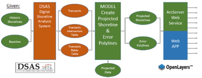
Historic shoreline positions in the database are derived from a range of remote sensing techniques in combination with field campaigns. The U.S. Geological Survey Digital Shoreline Analysis System (DSAS) is used to calculate rates of shoreline change, and DGGS staff have built a GIS model that extrapolates these rates of shoreline change to illustrate a projected future shoreline position (Figure 1). This model incorporates errors from the DSAS calculations, which are presented as a confidence interval surrounding the predicted shoreline (Figure 2).
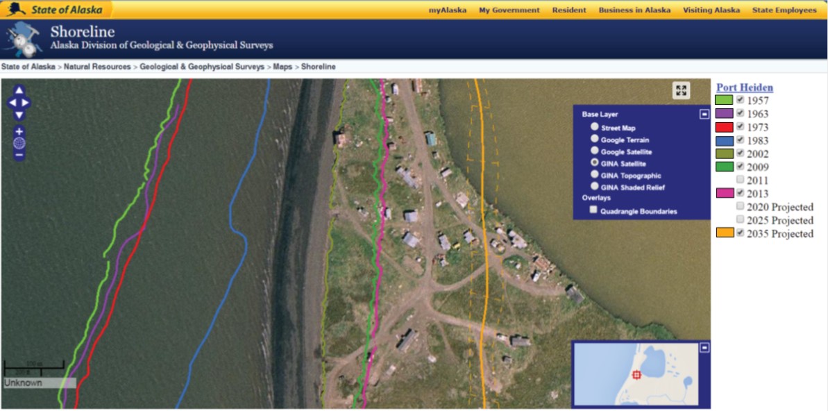
Local officials are already using this tool to make more informed decisions about the managed retreat of critical infrastructure.
The dashed orange lines represent the 2035 projected shoreline uncertainty
Although this tool presents simplistic linear trends, it serves as a valuable improvement to existing resources in Alaska for identifying, prioritizing, and planning for statewide coastal erosion issues. To help educate stakeholders about the uses and limitations of these types of analyses, DGGS staff are teaming up with science illustrators from the University of Alaska Fairbanks to prepare a comprehensive companion document and the live release of this web atlas is scheduled for April 2015.
ICAN Activities Endorsed by IODE Committee
- Detalles
- Categoría: News News
ICAN Steering Group members Ned Dwyer, Dawn Wright, Lucy Scott and Linda Pikula demonstrated the strong commitment of ICAN to IODE at the IODE-XXIII meeting held from 17-20 March 2015 in Bruges, Belgium. This biannual meeting was attended by representatives of all IODE projects, delegates from the National Oceanographic Data Centres of IOC member countries and observer projects. The proposed ICAN work plan and budget proposal for 2016-2017 was accepted by the Committee underlining that ICAN activities are of great relevance to IODE members.
Other IODE projects presented during the meeting and of particular interest to ICAN include OceanDocs and Ocean Data Practices. OceanDocs (http://www.oceandocs.org/) is an e-repository of scientific publications related to marine science and oceanography which ICAN should take advantage of for its own holdings. The Ocean Data Practices service (http://www.oceandatapractices.net/) which is aimed at promoting the use of common methodologies in ocean data and information management and improved interoperability between these systems could also be a mechanism ICAN could use to disseminate its own best-practice guides.
- The ICAN plan and budget is available at:
http://www.iode.org/index.php?option=com_oe&task=viewDocumentRecord&docID=14496 - The full report from the IODE-XXIII meeting is available at:
http://www.iode.org/index.php?option=com_oe&task=viewDocumentRecord&docID=14791

CoastGIS 2015: Rich Data, Poor Data
- Detalles
- Categoría: News News

Rich Data, Poor Data: Geospatial Creativity and Innovation for Managing Changing Coastal Systems is the theme for the 12th International Symposium for GIS and computer mapping for coastal zone management, for the first time held in Africa from 21-24 April 2015 in Cape Town. CoastGIS 2015 follows as it did in Ostende, Belgium and Victoria, Canada, the workshop for the International Coastal Atlas Network.
The program and registration information is available on the conference website
http://www.coastgis2015.co.za/
The keynote speakers will be:
Shankar Aswani, Rhodes University, South Africa
Dr. Aswani’s research has focused on a diversity of subjects including property rights and common property resources, marine indigenous ecological knowledge/ethnobiology, vulnerability and resilience of coastal communities, cultural ecology and human behavioural ecology of fishing, demography, ethnohistory, political ecology, economic anthropology, and applied anthropology involving geospatial technologies.
Clint Padgett, US Army Corps of Engineers, Mobile (Alabama) District
Dr. Padgett is the Spatial Data Branch Chief encompassing oversight of the Geospatial, Survey & Mapping, Dredge Quality Management, and Joint Airborne Lidar Bathymetry Technical Center of Expertise groups.
Andrus Meiner, Head of Ecosystems Assessment Group, European Environment Agency (EEA)
Dr. Meiner’s responsibilities have involved contributions to EEA main state of environment reports in 2003, 2005, 2010, and 2015. During 2004-2012 he acted as project manager for integrated spatial assessment of coastal environment and indicator development for ICZM.
Ron Furness, Darius Bartlett and Roger Longhorn will tag team a presentation on 20 years of CoastGIS. Mr. Furness and Mr. Bartlett were the instigators of the CoastGIS series of symposia in 1995 in Cork, Ireland. Mr. Furness Ron retired from the Australian Hydrographic Service as the then senior civilian and Director, Coordination and Development in 2002. He is now a consultant for the global geospatial company IIC Technologies Ltd. Mr. Bartlett is a lecturer at the Department of Geography, University College Cork (UCC) in Ireland and a member of the Geoinformatics research cluster within the Geography Department. Mr. Longhorn, was an external expert in information systems and services, and development of the pan-European Spatial Data Infrastructure (INSPIRE), for the European Commission until 1999. Roger is now Secretary-General of the Global Spatial Data Infrastructure (GSDI) Association and serves as external expert on the IHO’s Marine Spatial Data Infrastructure Working Group (MSDIWG).
Two workshops will be held on Tuesday 21 April 2015:
Coastal/Marine SDI Capacity Building Workshop – Managing Big Data Challenges
This full day workshop is organised by Roger Longhorn, Secretary-General, GSDI Association and an external expert member of the IHO Marine SDI Working Group. Roger is joined by Dr Mike Osborne, Managing Director, OceanWise Ltd, Steering Group Member of the UN-IOC Caribbean Marine Atlas Project and co-founder and expert contributor to the IHO Marine SDI Working Group.
Contacts:
Esta dirección de correo electrónico está siendo protegida contra los robots de spam. Necesita tener JavaScript habilitado para poder verlo.
Esta dirección de correo electrónico está siendo protegida contra los robots de spam. Necesita tener JavaScript habilitado para poder verlo.
Coastal LiDAR Workshop
This workshop will build on the experience of previous workshops on the topic which have been conducted in the context of CoastGIS and locally in South Africa.
The aim of this workshop will be to amalgamate past workshop outcomes and take them further through the “cross-pollination” between the International CoastGIS and the African coastal LiDAR communities; get additional input and inspirations from the coastal LiDAR experts at the U.S. Army Corps of Engineers who will co-host this workshop (see below); and address coastal LiDAR related topics which are of particular interest to the African coastal research and management community.
Contact:
Melanie Esta dirección de correo electrónico está siendo protegida contra los robots de spam. Necesita tener JavaScript habilitado para poder verlo.
Launch of the Global Information System on Small-Scale Fisheries (ISSF)
- Detalles
- Categoría: News News
The Too Big To Ignore (TBTI) international initiative (http://toobigtoignore.net/) has officially released the first version of their global Information System on Small-scale Fisheries (ISSF), a Web crowdsourcing platform allowing anyone to enter or access information on small-scale around the world. Discover hundreds of individual and organizations studying small-scale fisheries, more than a thousand publications, and soon data on small-scale fisheries from around the world. Contribute your knowledge of small-scale fisheries to the world: http://issf.toobigtoignore.net/
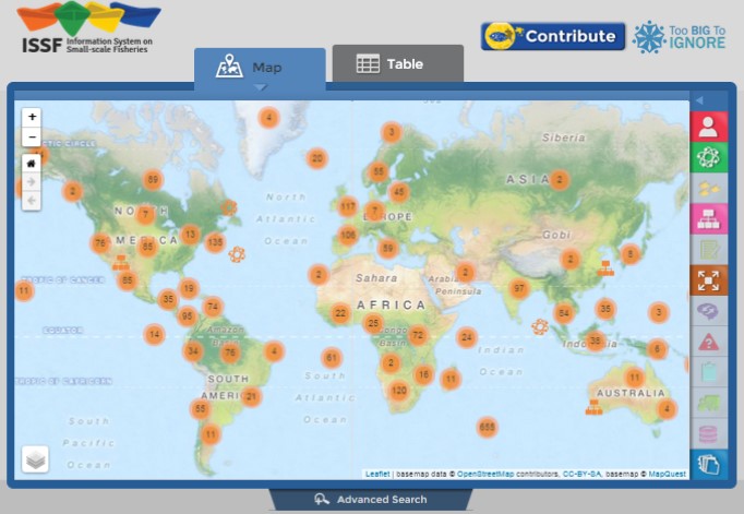
The ISSF is based on a 3-tier architecture composed of a spatial database (PostGIS), a web framework (Django) and a web-mapping client (Leaflet). The database stores relevant SSF information, such as the description and locations of SSF case studies, researchers and organizations. Data were compiled using reviews of the literature and surveys, and will be enriched through a crowdsourcing platform that will allow stakeholders to enter SSF data. The web framework makes the link between the database and the client by translating queries. Data are then presented to the end-user in a web-mapping environment and can be explored using a map or a tabular view. Tools are also provided to help users refine queries, such as filtering selections or performing spatial queries. Users can export in KML or CSV the results of the selection, as well as view and print reports for specific SSF entries. Using ISSF, researchers can conduct a variety of analyses, from simple scenarios handled by ISSF to more complex scenarios analyzed in third party software.
The ISSF is being developed at Memorial University of Newfoundland, St. John’s NL, Canada. Contact: Dr. Rodolphe Devillers (Esta dirección de correo electrónico está siendo protegida contra los robots de spam. Necesita tener JavaScript habilitado para poder verlo.)