
News
NOAA’s Gulf of Mexico Data Atlas joins ICAN
- Detalles
- Categoría: News News
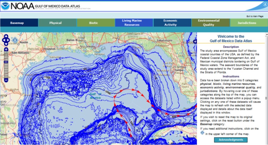
ICAN is very pleased to welcome it's latest member, the Gulf of Mexico Data Atlas (http://gulfatlas.noaa.gov). From the atlas summary: "As plans to restore the Gulf of Mexico after recent disasters have progressed, federal and state agencies have turned to NOAA for data and information about all aspects of the Gulf of Mexico. One of the most requested resources for that data and information has been the "Gulf of Mexico Coastal and Ocean Zones Strategic Assessment Data Atlas" published by NOAA's National Ocean Service in 1985 as a large hardcopy tabletop book. The new Gulf of Mexico Data Atlas updates and expands that publication in an online, digital format."
Management and technical developments of the Venice Lagoon Atlas: a brief update
- Detalles
- Categoría: News News
Alessandro Mulazzani (Esta dirección de correo electrónico está siendo protegida contra los robots de spam. Necesita tener JavaScript habilitado para poder verlo.), City of Venice- Osservatorio della Laguna e del Territorio;
Claudia Ferrari (Esta dirección de correo electrónico está siendo protegida contra los robots de spam. Necesita tener JavaScript habilitado para poder verlo.), City of Venice- Osservatorio della Laguna e del Territorio;
Stefano Menegon (Esta dirección de correo electrónico está siendo protegida contra los robots de spam. Necesita tener JavaScript habilitado para poder verlo.), ISMAR-CNR,
Alessandro Sarretta (Esta dirección de correo electrónico está siendo protegida contra los robots de spam. Necesita tener JavaScript habilitado para poder verlo.), ISMAR-CNR,
Matteo Morgantin (Esta dirección de correo electrónico está siendo protegida contra los robots de spam. Necesita tener JavaScript habilitado para poder verlo.), CORILA
Andrea Rosina (Esta dirección de correo electrónico está siendo protegida contra los robots de spam. Necesita tener JavaScript habilitado para poder verlo.), CORILA
As outlined in 2011 at ICAN 5, one of the main goals of the Atlas of the Lagoon of Venice (www.atlantedellalaguna.it) is the establishment of a “federation” which should include all the bodies involved in geospatial data production for the Venice Lagoon. From the technical point of view this federation is supported by the “Collaborative Interoperable Geographic Nodes” (or CIGNo) i.e. GeoWeb platforms based on a personalised version of the GeoNode platform (http://geonode.org) developed by the Marine Science Institute of the National Research Council (ISMAR) and by the Consortium for Coordination of Research Activities Concerning the Venice Lagoon System (CORILA).
After one and a half years this goal has been reached. In April 2012, the City of Venice, the promoter of the Atlas, signed a formal agreement with the ISMAR and CORILA for joint management of the Atlas. The partners started to develop together the new Atlas CIGNo, the node to be used for the Atlas’s maps managing and publishing, connected to the already implemented ISMAR node and CORILA node.
A Working Group formed by experts from the three bodies, meet monthly to plan the development of the Atlas.
In January 2013, two major data producers joined the Working Group: the Veneto Region and the Venice Lagoon Water Authority (Magistrato alle Acque), recognising the Atlas as the key tool for accessing and sharing geographical information on the Lagoon of Venice.
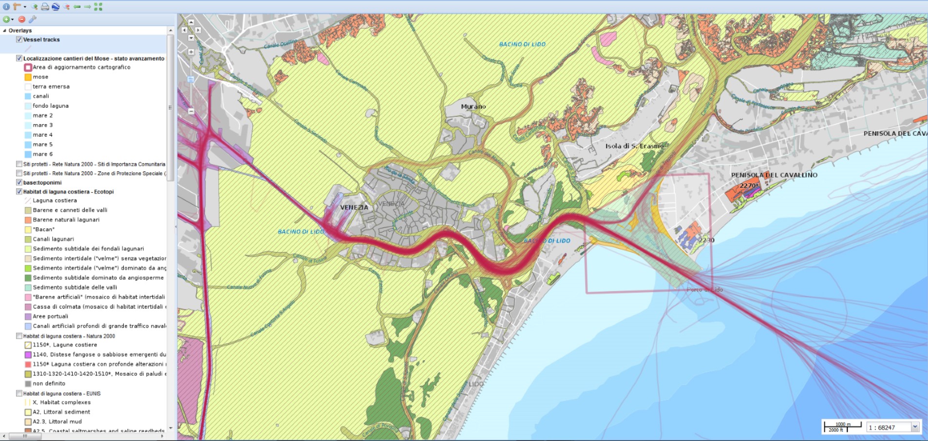
In February 2013 the conversion of 355 geographical layers stored in the Atlas has been completed, to allow their publication through CIGNo. All the published maps are now accessible with the new map engine, which is more flexible and up to date.
In 2012 the www.atlantedellalaguna.com portal reached an average of 2150 visits per month.
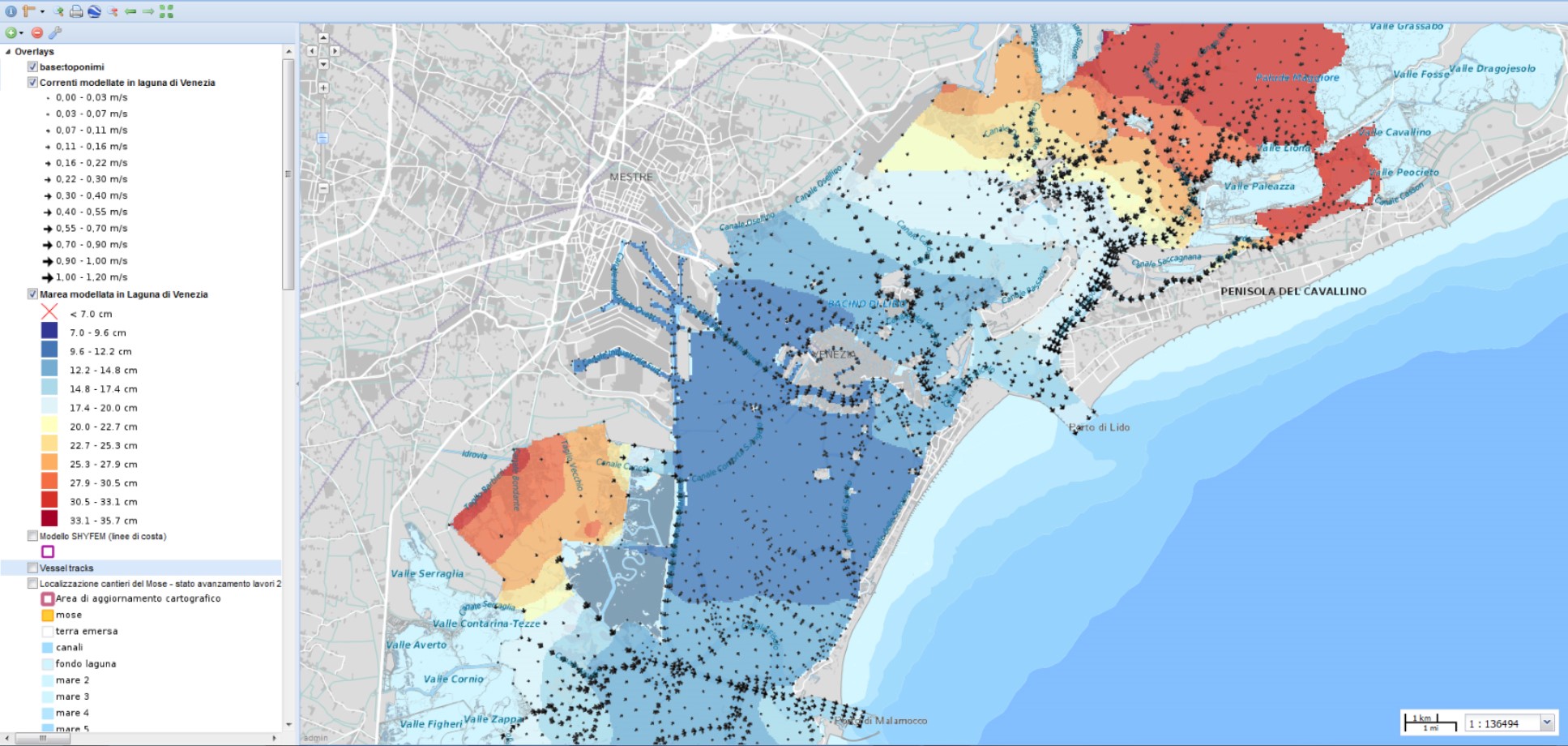
From the users point of view, the new Atlas management enriches the contents available on the geoportal (e.g.: a work carried out by ISMAR produced very interesting maps on real-time tide height and current speed, which become available quickly for the Atlas users).
The technical improvements allow a better visualisation of the maps, where extra layers can be freely added, directly from ISMAR and CORILA nodes, or from any other geoservices using the OGC’s WMS protocol.
More work needs to be done on several issues, such as Compiling standard metadata, and creating of new thematic maps. Greater interaction with users is planned, for example creating map layers with users’ contributions via smartphone app data.
The 2011 EU Commission report on “Options for coastal information systems” (http://ec.europa.eu/environment/iczm/ia_studies.htm) suggested the Atlas needed enhancements on:
- the understanding of environmental issues (climate change, pollution, subsidence, etc.);
- economic activities (i.e. fisheries);
- governance;
- scenarios; and
- evaluations of project/plans and alternatives,
However the agreement with nearly all the regional and local data producers, is favourable for the Atlas of the lagoon as an excellent pilot project demonstrating cooperation among research institutes and local/regional governments with the purpose to make environmental information available to all, for education, planning and to increase citizens’ environmental awareness.
EBM Tools Network releases Free Guide to Coastal Climate Planning Tools
- Detalles
- Categoría: News News
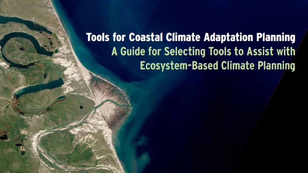
Arlington, Virginia (March 14, 2013)—The potential impacts of climate change are already influencing the choices that coastal communities, resource managers, and conservation practitioners are making for ecosystems and infrastructure. To help planners and managers prepare for the far-reaching effects of these changes, the EBM Tools Network today released a free publication, Tools for Coastal Climate Adaptation Planning: A guide for selecting tools to assist with ecosystem-based climate planning.
The guide is designed to assist practitioners responsible for understanding and preparing for climate-related effects. By focusing on software and web-based applications that leverage geospatial information, Tools for Coastal Adaptation Planning will help these professionals account for the health and well-being of ecosystems and human communities in projects and plans.
The guide targets practitioners and decision makers involved in conservation, local planning, and the management of coastal zones, natural resources, protected areas, habitat, and watersheds in the coastal United States including the Great Lakes. In addition to detailed information about a key collection of visualization, modeling, and decision support tools, Tools for Coastal Climate Adaptation Planning offers instructive case studies about how other professionals have successfully applied the tools in a several coastal communities in the United States. Professionals from inland and international regions will also benefit from the guide’s tool information and lessons.
Funded with the support of the David and Lucile Packard Foundation and the Keith Campbell Foundation for the Environment, Tools for Coastal Climate Adaptation Planning can be downloaded for free at www.natureserve.org/climatetoolsguide
COINAtlantic introduces Version 2 of its Search Utility
- Detalles
- Categoría: News News
Andy Sherin
Director, ACZISC Secretariat
Esta dirección de correo electrónico está siendo protegida contra los robots de spam. Necesita tener JavaScript habilitado para poder verlo.
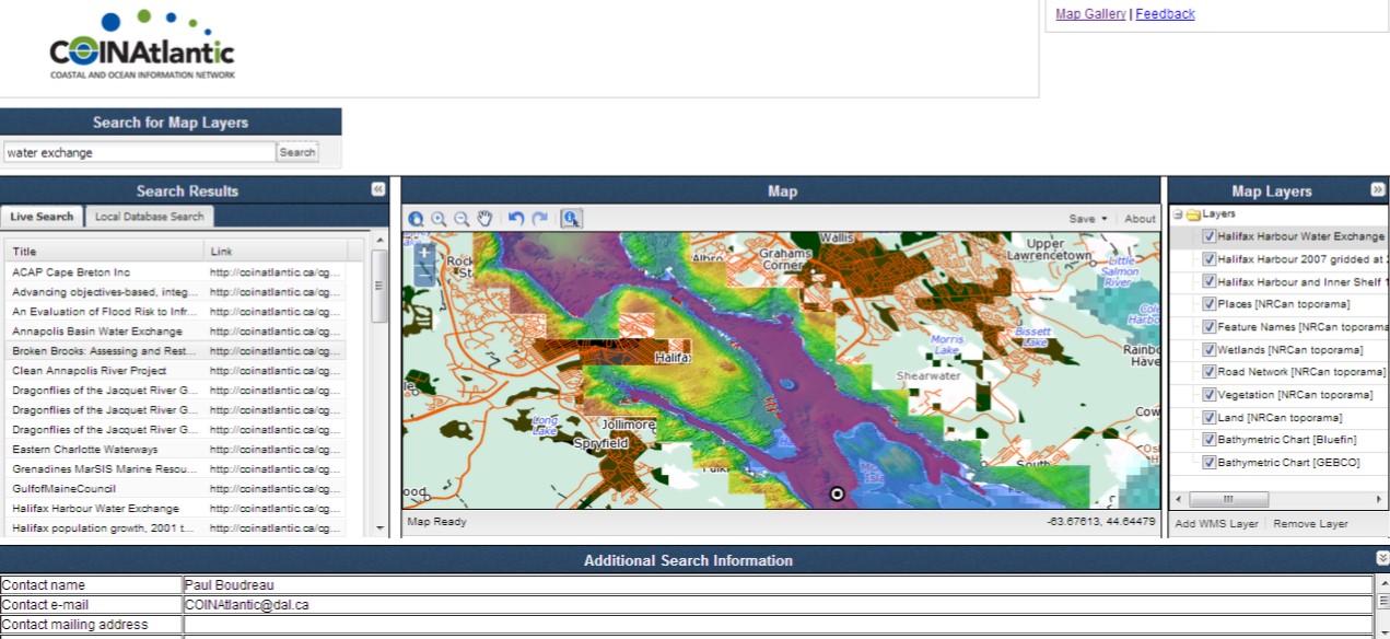
The Atlantic Coastal Zone Information Steering Committee (ACZISC) has released version 2 of the COINAtlantic Search Utility (CSU2). The CSU2 is a web-based tool that searches the internet for spatial data resources that meet the search criteria of the user and enables the user to add the resulting spatial resources to an interactive map (see Figure). The CSU2 uses the Google search API to find spatial data resources in KML or as OGC Web Mapping Services (WMS) and displays the first twenty results for the user to choose from to add to the map. The user can also add a layer to the map from a WMS they know the url for. The CSU2 is customizable taking the default map layers from an editable configuration file. Online mapping is done using the Open Source Geospatial Foundation's OpenLayers Web mapping software.
Version 2 replaces COINAtlantic Search Utility Version 1 released in 2008 that relied solely on searching one data base via an API, Canada’s GeoConnections Discovery Portal (GDP). Initially the GDP was intended to grow to be a national repository for metadata, but over the years, organizations developed their own data bases so the GDP focussed mostly on spatial data delivered by one department of the Canadian federal government. This development severely limiting the scope of searches that could be satisfied. CSU2 was designed to bypass accessing individual data bases and use the ubiquitous internet searches to find spatial data resources.
The CSU2 works together with the COINAtlantic GeoContent Generator (CGG), another web-based tool developed by the ACZISC. The CGG enables a user to describe an organization, a project, a report or publication of a data set with basic attribute information (see Table) and link it to a point, line or polygon that describes the spatial extent of the entry. The tool then builds a KML file of the attribute and geographic information and stores it as a file on the ACZISC site and informs the Google search utilities of its location using a Sitemap submission. The CSU2 automatically refers to these files when executing a search.
The user can describe the geography of the entry in the CGG in three ways:
- By hand drawing a point, line or polygon;
- By using one of the polygons from the CGG library of polygons for jurisdictions (e.g. municipal boundaries) and biophysical areas (e.g. watersheds); or
- Uploading an existing KML file from their computer.
Enhancements to the tools are planned. For the CGG, the user friendliness of the interface for the CGG will be improved, the library of KML polygons for users to choose from will be expanded, and the functionality to permit users to edit their own files will be introduced. For the CSU2, the legend functionality will be improved, ways for the user to add WMS layers to the interactive map will be expanded, inclusion of Catalog on the Web (CWS), Web Feature (WFS) and Web Processing (WPS) services will be investigated, and the migration to an open source GIS infrastructure will take place.
The CGG and the CSU2 are available for use and exploration at www.coinatlantic.ca/cgg and www.coinatlantic.ca/csu respectively. The ACZISC Secretariat would appreciate any feedback on your experience using these tools. Please contact us with your comments at Esta dirección de correo electrónico está siendo protegida contra los robots de spam. Necesita tener JavaScript habilitado para poder verlo.
| Attribute | Mandatory | Description |
| Type of entry described | Controlled list | Permitted values: an organization, a project, a publication, or a data set. |
| Contact name | Yes | Name of the person making the entry |
| Contact e-mail | Yes | E-mail of above |
| Title | Yes | Short title for the entry |
| Description | Yes | Verbose description of the entry for full text indexing by Google |
| Contact mailing address | No | Mailing address of contact name |
| Geographic location | No | Textual description of the geographic location for the entry |
| Dataset language | No | Language or languages for the entry |
| URL website address | No | The URL of a relevant website e.g. for the organization, etc. |
| URL mapping service | No | If the entry describes an OGC compatible service, the GetCapabilities URL |
| URL standard metadata | No | If standardized (e.g. ISO) and more detailed metadata exists, the URL that provides access to it. |
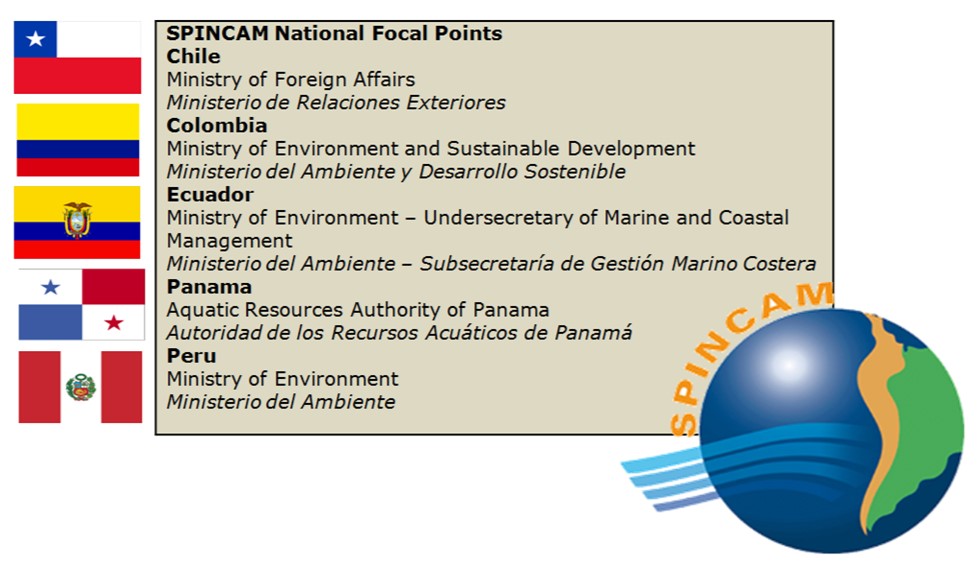
Southeast Pacific region (Chile, Colombia, Ecuador, Panama and Peru) will join ICAN through SPINCAM Project
- Detalles
- Categoría: News News
Julian Barbière (IOC-UNESCO),
Fernando Félix (CPPS),
Alejandro Iglesias-Campos (ICAN)
Introduction to SPINCAM
The Southeast Pacific data and Information Network in support to Integrated Coastal Area Management, SPINCAM Project (www.spincamnet.net) , aims to establish a coastal management indicator framework in each country of the Southeast Pacific region (Chile, Colombia, Ecuador, Panama and Peru), focused on environmental and socio-economic conditions within the context of sustainable development and integrated coastal area management.
The project is being executed through the Intergovernmental Oceanographic Commission (IOC/UNESCO) (http://ioc-unesco.org) with the financial support of the Government of Flanders (Belgium) (www.flanders.be).
Specifically, SPINCAM aims to create an information system at national and regional level that support the development of indicators, their spatial representation, and the dissemination of ICAM (Integrated Coastal Zone Management) resources and experiences with the following objectives:
- To support the implementation and effectiveness of ICAM through the improvement of data and information management capacity, knowledge, communication and networking at regional and national level;
- To improve the delivery of data and information on the status of coastal resources and their management for the use by all coastal stakeholders (decision makers/civil society);
The expected outcome of the project is to build technical and managerial capacity for the development of indicator-based reports (state of the coast report for decision makers/civil society), including their spatial representations within the framework of existing national and regional ICAM programmes.
ICAM in Latin America
Integrated Coastal Area Management (ICAM) is a process that unites government and the community, science and management, sectoral and public interests in preparing and implementing an integrated plan for the protection and development of coastal ecosystems and resources. Since the 1990s the concept of ICAM has been recommended by UNCED (Rio de Janeiro, 1992) and, more recently, WSSD (Johannesburg, 2002), as well as several global and regional Conventions (CBD, 1995; GPA-LBA, 1995; Regional Seas Convention, revised in 1995). These instruments have recognized ICAM as way to achieve the sustainable management of the coastal zones.
ICAM initiatives have been implemented in Latin America and Caribbean countries, most of them at sub-regional and local level. Some of these projects were successful, and there are lessons to be learned from them. The establishment of a dedicated coastal management network at the regional level is needed to support the sharing of information, experience and expertise not only amongst the countries, but even within the countries,among different agencies, institutions, and stakeholders who share a common interest for the management of coastal zones.
At the regional level, the Permanent Commission for the South Pacific (CPPS, in Spanish) (www.cpps-int.org), which includes Chile, Peru, Ecuador and Colombia, is the organization responsible for the coordination of marine policies of its Member States. Through the Action Plan for the Protection of the Marine Environment and Coastal Areas of the Southeast Pacific (Lima Convention), in which a fifth country, Panamá is also a partner, countries have agreed to work collectively for the wise planning of coastal zones.
In 1989, with the formal approval of the Plan for Territorial Organization of Marine and Coastal Zones, on the occasion of the fourth Intergovernmental Meeting of the Southeast Pacific Action Plan, this regional cooperation mechanism, supported by UNEP and other international organizations, initiated the execution of activities on integrated coastal management. The objective of the Plan for Territorial Organization of Marine and Coastal Zones is to develop regional policies and actions for sustainable territorial planning, as well as to promote capacity building in the field of marine and coastal zone management in the Southeast Pacific countries. From the start of the SPINCAM project in 2008, the need to frame the project in response to the existing regional governance framework was recognized, and as a result CPPS was requested to act as the regional coordinator of the project.
The SPINCAM project contains a substantial data and information management component that underpins the development of indicator-based reports at national and regional level.
The principal mechanism for managing and exchanging oceanographic data and information within the region is the Ocean Data and Information Network for the Caribbean and South America region (ODINCARSA) (www.odincarsa.org), which is a project of the International Oceanographic Data and Information Exchange (IODE) (www.iode.org) programme of the IOC/UNESCO.
ODINCARSA was set up to strengthen ocean data and marine information management capacity in the Caribbean and Latin America region in order to contribute to Ocean Sciences, operational oceanography development and integrated coastal management activities at the regional level.
Launched in 2001, the IODE programme established a regional network of more than 60 National Institutions within 19 IOC Member States, with 237 experts from different sectors related to ocean and marine activities. ODINCARSA is an excellent platform for ICAM projects in the region and connections have been built and consolidated with Governmental organizations, especially in Pacific South America to support ICAM initiatives in this region.
A core element of the IODE data system is the National Oceanographic Data Centre (NODC). This national facility is responsible, at the national level, for the quality control and archiving of oceanographic data as well as for the dissemination of these data (and products) to users; at the international level, the NODCs exchange data with other NODCs in the IODE network and they provide the national data to the ICSU World Data Centres for Oceanography for global dissemination. The development and support of NODCs in the Caribbean and South America region is one of main objectives of ODINCARSA.
In terms of marine information (library) management, ODINCARSA has made considerable progress in building information networks such as the Latin American Group on Marine information management and the Regional working Group on Digital repository (OceanDocs). ODINCARSA has furthermore actively promoted active and effective relationships among marine institutions in the Project area and is a suitable partner to enhance the SPINCAM Information system where the NODCs role will be paramount in providing data for the development of coastal indicators and their dissemination to various stakeholders.
SPINCAM II – Towards a Southeast Pacific Coastal Atlas
SPINCAM II seeks to strengthen the integrated coastal management processes initiated in the first phase of the project, the development of tools to support decision-making and to improve capacities on data and information management, knowledge, communication and networking at national and regional level, attending the needs of each country.
This second phase will emphasize the need to institutionalize the SPINCAM project. Another crucial issue is to define clear and effective mechanisms at the national level for funding future developments and maintenance of SPINCAM outputs, as well as to promote training processes.
The Project will be structured in this second phase around four specific objectives:
- To strengthen the framework of national and regional ICAM indicators to assist in decision making through partnerships and collaborations among institutions.
- To coordinate and integrate further coastal and marine data and information systems at national level through the IODE National Oceanographic Data Centers.
- To design and implement a strategy for dissemination and awareness of the ICAM indicator framework among local and regional stakeholders.
- To promote continuous training and formation to strengthen the institutional capacities.
SPINCAM Coastal Web Atlas
The development of indicators on the state of the coast during the first phase of SPINCAM Project has facilitated the implementation of a geoportal as a work space which maintains, exchanges and displays the spatial information and experiences among countries.
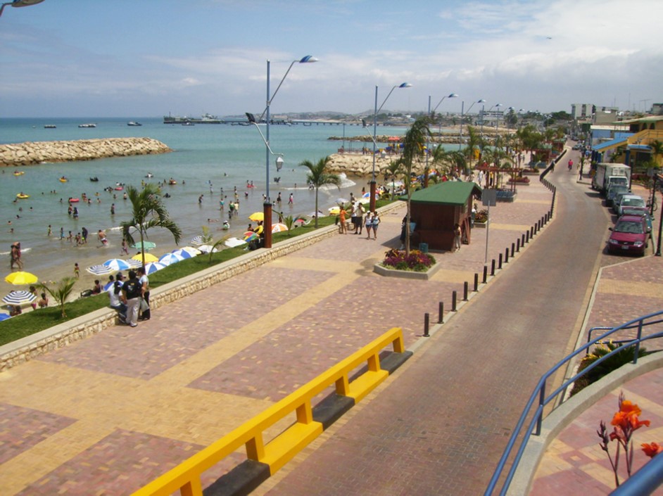
The SPINCAM Coastal Atlas (http://190.95.249.246/geoportal/geovisor/index.html) is structured with an interactive legend for the active layers, an overview of the region, the main viewer with different functionalities and the list of layers available.
Layers of information currently available for all countries are coastal and marine protected areas, population density in coastal regions and the quality of coastal and marine waters.
Besides the information on coastal indicators, data from other sources, such as the IOC/Flanders/CPPS project, the Southeast Pacific Information System on Biodiversity and Protected Areas (SIBIMAP/SEPIS) can be easily uploaded.
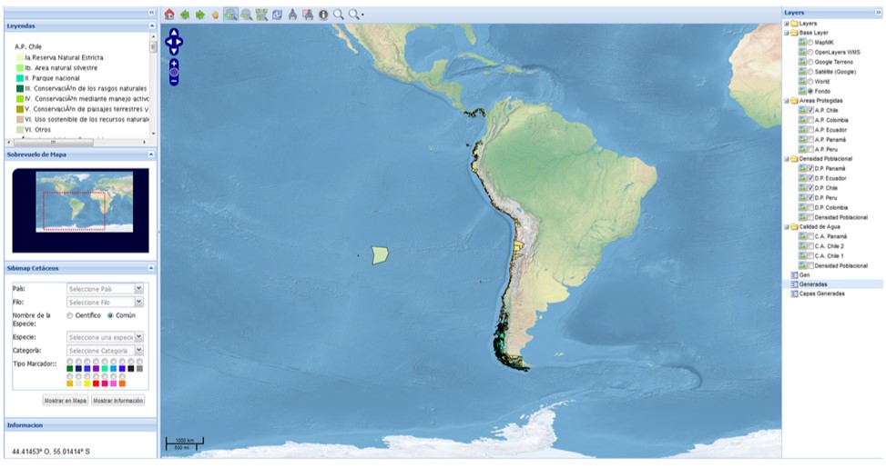
In addition, the Atlas allows combining layers of coastal indicators and layers with information on cetaceans, sea turtles and sharks, and their respective metadata
The data viewer contains in its initial stage functionalities that will be extended during the second phase of the project. Currently, the user is allowed to zoom in/out, pan, to obtain information about the attributes of information shown and the ability to add layers of information from the user.
SPINCAM and ICAN
Since 2011, representatives of International Coastal Atlas Network (ICAN) have joined the SPINCAM workshops emphasizing the value of information in integrated coastal zone management and the pillars of Integrated Coastal Zone Management: 1) environmental data, indicators, tools 2) dissemination and good practices and 3) importance of knowledge for public participation and cooperation worldwide.
The membership of SPINCAM in ICAN increases the area of cooperation and collaboration with other Coastal Web Atlases in Latin America and the Caribbean that favour the exchange of experiences and good practices, both in terms of technology development, content and exploitation of coastal atlases.
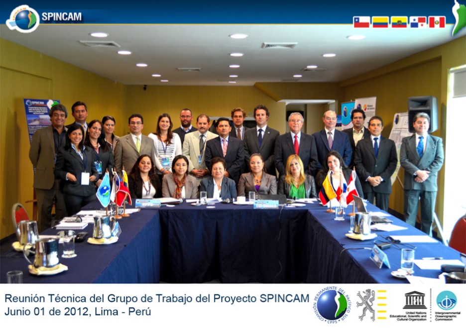
As a first contact with the ICAN Community, SPINCAM will participate in the next ICAN event, and will lead a side event on the advances in the implementation of the Southeast Pacific Data and information Network in Support to Integrated Coastal Area Management (SPINCAM) Project (IOC-UNESCO/Flanders/CPPS) during the CoastGIS 2013 Conference, 18-21 June 2013 in Victoria, British Columbia, Canada.