
News
Smart Atlas Enhances Marine Data Sharing in Africa
- Detalles
- Categoría: News News
Ali Al Othman(Esta dirección de correo electrónico está siendo protegida contra los robots de spam. Necesita tener JavaScript habilitado para poder verlo.), Yassine Lassoued(Esta dirección de correo electrónico está siendo protegida contra los robots de spam. Necesita tener JavaScript habilitado para poder verlo.)
Coastal and Marine Research Centre, University College Cork, Cork, Ireland
As part of UNESCO’s International Oceanographic Data and Information Exchange (IODE) Ocean Data and Information Network of Africa (ODINAFRICA) project, the Coastal and Marine Research Centre (CMRC) has developed a second version of the underlying technology used in the Marine Irish Digital Atlas (MIDA: http://mida.ucc.ie ). This system called Smart Atlas is being deployed and used by ODINAFRICA partners. Smart Atlas includes up-to-date web mapping technologies to make it easier to explore coastal and marine information through the development of web-enabled, customised Geographic Information System (GIS) that allows users to visualise and identify marine sources of data. A key feature of Smart Atlas is that it promotes and supports distributed marine dataset sharing, which is vital to facilitate marine information exchange between coastal African states.
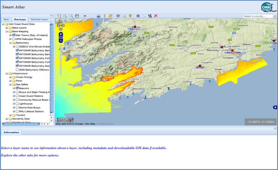
This project follows INSPIRE (Infrastructure for Spatial Information in Europe) Directive recommendations for Data discovery, view, and download services. Being conformant to well established web services makes the services developed available to other organisations to consume and view with minimum effort of integration. The new web client mapping application features expanded functionality, plug-in-free animation, and a new architecture with a rich user experience for every browser. The system provides greater accessibility to data and information in the form of a web enabled and customized GIS, data access and data analysis combined with mapping tools for identification of data sources, visualisation, management, and analysis for different use case scenarios.
Smart Atlas is developed using open source software technology with greater performance, a much more simplified, flexible, and customisable interface using the latest JavaScript frameworks and it supports new mapping tools for adding features, zooming, drawing, measuring, and customised printing. Smart Atlas Layers contain views of layers organised in different tabs with built-in base layers, such as Google maps and Open Street maps, overlays that includes the atlas layers and selected layers that contains the list of active layers, sorted by depth, with the possibility of changing the layer order and layer transparency.
Smart Atlas introduces the integration of Catalogue Services for the Web (CSW). The atlas can be configured to connect to metadata catalogue servers (e.g. Geonetwork, ESRI ArcServer, etc.) so that users can search for data layers within the atlas or other metadata stores included in the search through the distributed CSWs.
Metadata provides information about the content, purpose, location of the data, as well as quality and reliability of the data itself. Using standard metadata web protocols makes the mediation and integration between different metadata providers seamless. Standardised metadata supports users in accessing data by using a common set of terminology and metadata elements. This allows for a quick means of data discovery and retrieval from metadata catalogue servers. The metadata based on standards ensures information consistency and quality, and avoids the loss of important knowledge about the data.
Smart Atlas supports distributed Catalog Service for the Web (CSW) search. The search can be done through a simple and advanced search. The user can simply enter free text in a box and hit the search button or do an advanced search using more detailed criteria like controlled vocabulary keywords that support a more standard search based on keywords pubpublished by standardization organizations. Users can also select a geographic extent for the searched metadata records. Participating metadata server catalogues can be selected by the user to be validated and included in the search.
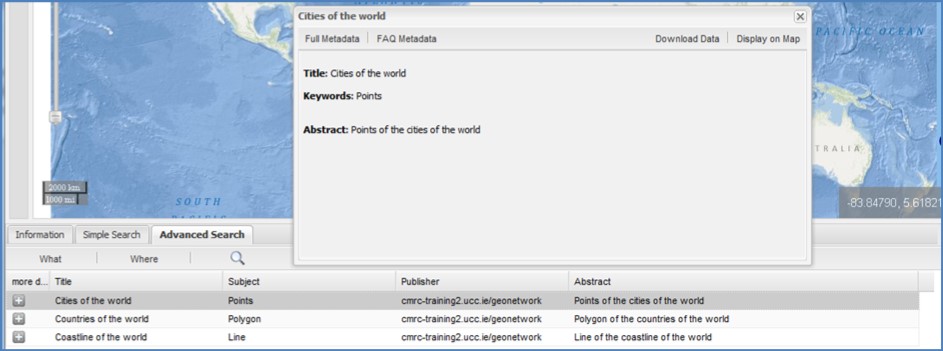
Three methods are used for presenting metadata record search results. These are Summary metadata record, Full metadata record and FAQ Metadata record viewed as a simple FAQ style where basic questions/answers about the metadata record are presented.
Once a particular metadata record is presented, it is also possible to either download the datasets associated with it or overlay these datasets on the mapping area through Web Map Service (WMS) for further analysis. This is designed to enhance spatial information exchange, and promote sharing between different organisations through instant search on local and distributed geospatial catalogues.
The CMRC is making Smart Atlas available for download and use via an open source free software license. Contact Ali Al Othman for further details and for the available support options. A Smart Atlas user training workshop for ODINAFRICA participants will take place in Nairobi, Kenya from 24 - 28 September 2012.
Activities of the ICAN Technical Team
- Detalles
- Categoría: News News
Roy Lowry (Esta dirección de correo electrónico está siendo protegida contra los robots de spam. Necesita tener JavaScript habilitado para poder verlo.) and Adam Leadbetter (Esta dirección de correo electrónico está siendo protegida contra los robots de spam. Necesita tener JavaScript habilitado para poder verlo.), BODC, Liverpool, UK,
Declan Dunne(Esta dirección de correo electrónico está siendo protegida contra los robots de spam. Necesita tener JavaScript habilitado para poder verlo.) and Yassine Lassoued (Esta dirección de correo electrónico está siendo protegida contra los robots de spam. Necesita tener JavaScript habilitado para poder verlo.) , Coastal and Marine Research Centre (CMRC), Cork, Ireland,
Tanya Haddad (Esta dirección de correo electrónico está siendo protegida contra los robots de spam. Necesita tener JavaScript habilitado para poder verlo.), Oregon Coastal Atlas Project, USA,
Liz O’Dea (Esta dirección de correo electrónico está siendo protegida contra los robots de spam. Necesita tener JavaScript habilitado para poder verlo.) State of Washington Department of Ecology, USA
ICAN Cookbooks
The last issue of the ICAN newsletter (Volume One, Number 1, March 2012) outlined the need for technical training material for costal web atlas developers in the form of cookbooks, and how the NETMAR project has produced cookbooks to contribute to this training material. In June 2012, the NETMAR team has revised and updated these cookbooks based on feedback. The cookbooks explain key information behind NETMAR’s ICAN demonstration pilot. Central to these cookbooks is material to help atlas developers connect to the International Coastal Web Atlas (ICWA) prototype. It is a prototype atlas mediator that provides a common interface for accessing distributed local atlases, such as MIDA (Marine Irish Digital Atlas), OCA (Oregon Coastal Atlas), Washington Coastal Atlas (WCA), etc. It uses a knowledge organization system to improve data discovery by exploiting the semantics of keywords and allowing users to search data by “meaning” rather than by “mere keywords”.
Four cookbooks are included which covers key material concerning the technologies and standards utilised by the ICWA prototype:
- Understanding Semantics;
- Understanding Metadata;
- Establishing a CSW metadata catalogue with GeoNetwork; and
- Connecting your Atlas to the ICWA prototype.
The “Understanding Semantics” cookbook provides a tutorial for those who wish to investigate and make use of semantic web and knowledge organization system technologies. These technologies fall broadly into three groups: vocabularies, thesauri and ontologies. This cookbook includes material explaining how to deploy semantics that are required by the ICWA prototype, utilising the NERC Vocabulary Server (NVS) infrastructure.
The “Understanding Metadata” cookbook provides a tutorial for those who wish to understand metadata. Included is a description of metadata and why we need it, metadata standards in use today, description of different metadata hierarchy levels, and a list of some metadata editing tools available. The section also references example metadata records aimed at system developers who are familiar with ISO 19115/19119 metadata implemented in ISO 19139 XML. These metadata examples include semantic keywords which are registered in the NVS.
The “Establishing a CSW metadata catalogue with GeoNetwork opensource” cookbook provides a tutorial for those who wish to understand CSW (Catalog Services for the Web) metadata catalogues. Included is a description of a metadata catalogue, the CSW standard, and a list of selected CSW servers. The document also contains initial pointers to establishing a CSW server using GeoNetwork open source and examples of selected CSW query operations aimed at system developers. GeoNetwork is recommended and used by the NETMAR project.
The “Connecting your Atlas to the ICWA prototype” cookbook provides a step-by-step guide explaining how to connect a local atlas as a node in the ICWA prototype utilising technologies and standards described in the other cookbooks. This cookbook specifies the ICWA connection requirements including metadata (ISO 19115/19119/19139), CSW metadata catalogues (CSW 2.0.2, ISO Metadata Application Profile version 1.0.0), and supported ISO 19139 encoding forms for semantic keywords.
The four cookbooks are available in a single PDF file that is currently located at: http://netmar.nersc.no/sites/netmar.nersc.no/files/D7.9.2_ICAN_semantic_cookbooks_r2_20120731_0.pdf
Please get in touch with Coastal and Marine Research Centre (CMRC) if you wish to give feedback.
International Coastal Web Atlas prototype
The Geomatics team of the CMRC, University College Cork (UCC), in partnership with the British Oceanographic Data Centre (BODC), are currently developing the third version of the International Coastal Web Atlas (ICWA) prototype as part of the EU FP7 NETMAR project. ICWA 3 will replace the current ICAN prototype and aims to become an operational web application that allows seamless and semantically enabled access to the ICAN atlases.
ICWA 3, which will be released by the end of October 2012, will include the following features and improvements since version 2:
- a standardised semantic resource structure based on SKOS (Simple Knowledge Organization System);
- an advanced thesaurus browser that displays term hierarchies, related terms, definitions, synonyms, etc. (Figure 1);
- smart search;
- the ability to connect an atlas without requirements for ontology development;
- improved storage and management of ontologies with faster access;
- a standardised semantic web service (SWS) will allow external applications to interact with the ICAN thesauri;
- support for Catalog Service for the Web (CSW) 2.0.1 and CSW 2.0.2 nodes,
- support for CSW 2.0.2 queries; and
- improved search performance.

Irish Government releases Integrated Marine Plan
- Detalles
- Categoría: News News
On 31 July 2012, the Taoiseach [Prime Minister of Ireland], Enda Kenny, launched an integrated marine plan titled “Harnessing Our Ocean Wealth”. Of interest to ICAN members is the inclusion in the plan of actions for developing marine Information and Communication Technologies and Marine Spatial Planning. For more information on the plan visit: http://www.ouroceanwealth.ie/Pages/default.aspx
The Coastal Marine Research Centre (CMRC) at University College Cork, home to our Irish ICAN members, responded to the plan by saying “CMRC is well placed to play a part in implementing the plan’s goals. Over the last ten years we have augmented research expertise in the chief sectors outlined in the plan, principally fisheries, tourism, oil and gas, renewable ocean energy and marine technology.”
Scotland's Marine Atlas Joins ICAN
- Detalles
- Categoría: News News
Martyn Cox,
Marine Planning and Policy, Marine Scotland
Esta dirección de correo electrónico está siendo protegida contra los robots de spam. Necesita tener JavaScript habilitado para poder verlo.
Introduction
Scotland is developing marine planning to provide integrated management of the Scottish marine environment and to manage the activities that take place there. The Marine (Scotland) Act 2010 introduces this and also requires an evidence base to be developed to support the development of our first National Marine Plan.
A tool for marine planning and an assessment of the seas Scotland’s Marine Atlas, published in March 2011 (hard copy, HTML and pdf) is that “Information for the National Marine Plan”. It is also an assessment of the condition of Scotland's seas, which is based on scientific evidence from data and analysis, supported by expert judgement.
The Atlas is an innovative publication which, for the first time, brings together and maps a huge range of information about Scotland’s seas. It takes on a coffee table atlas approach with spreads of information. The contents range from temperature, salinity and ocean acidification to habitats and species, from the value of fish landed to biotoxin monitoring and potential sites for marine renewables. The information is presented in a colourful and easily accessible way, with signposts to further information, and centres around maps to provide a spatial dimension.
Figure 1: Cover of Scotland's Marine Atlas
A collaborative effort
The Atlas was a significant collaboration between Marine Scotland, Scottish Natural Heritage, Scottish Environment Protection Agency, the Joint Nature Conservation Committee and the Marine Alliance for Science and Technology for Scotland. This collaboration ensured that all appropriate data collected by government and its agencies were included and allowed each section to be authored by the most appropriate expert. Material from over 100 authors was reviewed by non-Scottish bodies.
The data source and reference Annexes demonstrate the breadth of information used to present this comprehensive report (including non-Government bodies such as the Marine Conservation Society, Keep Scotland Beautiful and the Royal Yachting Association).
Presentation of the data
The data are categorised against the elements of the Scottish Government’s vision for the seas – clean and safe (hazardous substances, biological effects, eutrophication etc); healthy and biologically diverse (protected areas, species and habitats, etc); and productive (full range of economic activities). In addition there are more general sections on physical characteristics (waves, tides etc) and climate change. In this way, the Atlas provides a valuable report on the current state of the marine environment, the main pressures and impacts upon it and the value the seas provide to the national economy. As many data sets as possible are mapped based and presented with graphs around for them for ease of making spatially aware conclusions.
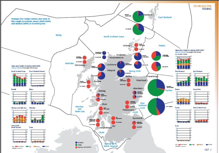
Figure 2: Fishing “spread” showing catches per sea area (graphs) and landings (pie charts)
Developing a web based version
A web-based GIS version is now under development to provide interactive maps and downloadable data sets based on those in the Atlas. At this stage the exact requirement for marine planning both in terms of data sets and its presentation are not known. We are taking an evolutionary approach by starting with making the Atlas available in a simple interactive tool and then asking stakeholders what more is required for marine planning at both the national and regional levels.
The National Marine Plan interactive (NMPi) http://www.scotland.gov.uk/Topics/marine/seamanagement/nmpihome version of the Atlas will have two key aims – to underpin the new statutory system of marine planning (nationally and regionally) and to educate and inform the wider public. To do this, it will bring together the large range of evidence used in the Atlas on-line for the first time. This includes data which are already relatively accessible (e.g. monitoring data required to report against European Directives) and other data, some of which have been commissioned specifically or analysed differently.
Where possible, data are presented at both a national and a regional scale, to aid planning at both these levels. Presenting data this way also creates challenges since many data sets have long established ways of being presented. Marine planning requirements will question the way some things are done.
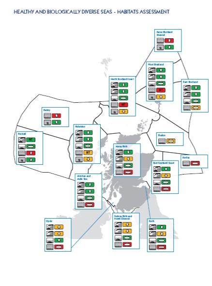
Figure 3: The habitats assessment part of the overall assessment highlighting the traffic light approach to assessing the habitats
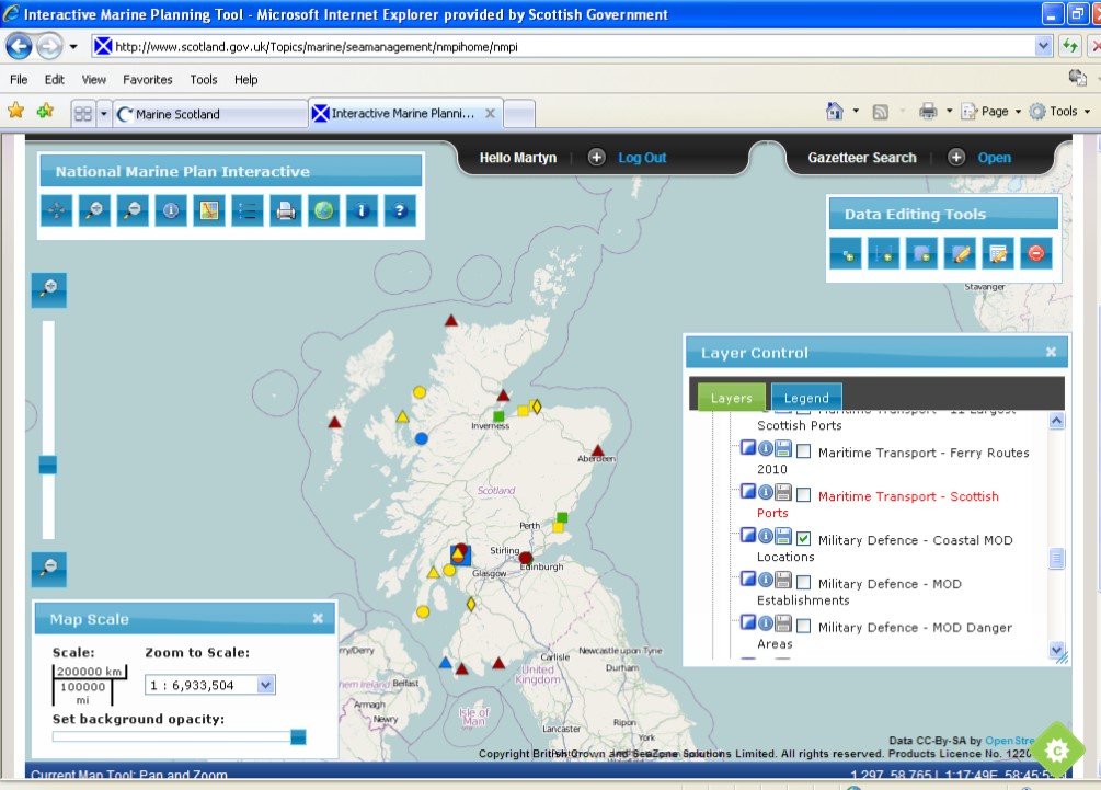
Figure 4: Screen shot of the developing national marine plan interactive
Challenges ahead
There will be many challenges ahead. The full breadth of requirement for marine planning is not known and the spatial tool will have to evolve. In doing this there will be many, no doubt competing, demands. In a time of government financial restraint the system will evolve as we establish what is required and what can be afforded.
Accessing data still remains an issue, not all sets can be openly shared without restriction yet, as does keeping any data sets up-to-date. The rapid rate of technological change will no doubt create a challenge as the possibilities are ever increasing. What we do know is that we need to do this: we have a legislative requirement and stakeholder expectations to meet.
Florida Atlas Programs Bring Water to the Web
- Detalles
- Categoría: News News
 The goal of this innovative web-based tool is to help the public understand our natural waters and to be a one-stop data warehouse for water managers. Using Geographic Information Systems (GIS), active web pages and web-enabled database management systems, the Water Atlas websites are designed to provide citizens, scientists, resource managers, and educators with water quality, hydrologic and ecologic data. In addition, they provide information about local conservation efforts, volunteer and recreational opportunities, and a library of scientific and educational materials on water-resource issues.
What is the Water Atlas?
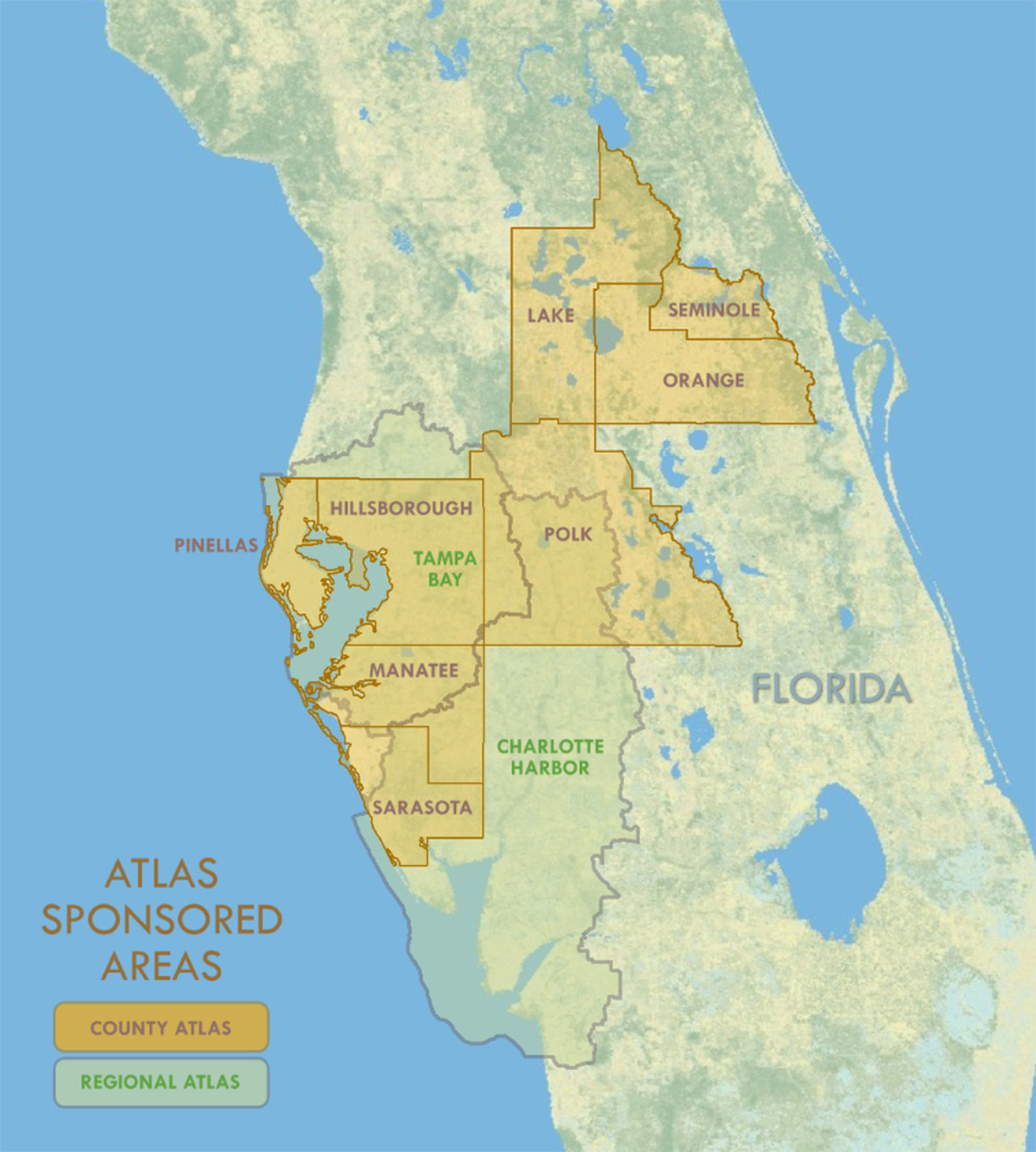
The Water Atlas program is a collection of websites created and administered by the Florida Center for Community Design and Research at the University of South Florida in Tampa. Originally created as an atlas of Hillsborough County lakes in 1997, it has expanded both geographically and functionally, now including eight county Atlases the Tampa Bay Estuary Atlas, and the Charlotte Harbor Estuary Atlas. In addition to lakes, it also contains water quality and hydrologic data for other types of waterbodies, including ponds, rivers/streams, bays, estuaries and inshore marine waters, as well as the watersheds that bind them together.
The mission of the program is to “provide a comprehensive information resource that helps citizens, scientists and resource managers make informed decisions concerning our vital water resources.” It does this by providing a spatially-organized view of water resource data. It has information from over 225 different data sets that is available to the public in multiple formats. It attempts to give that data meaning by providing “Learn More” articles that tell users how samples are collected and how to interpret them. Atlas users can display data in tabular form, graphically in tables and graphs, or their geographic context via interactive mapping applications. Researchers can download data for further analysis. Agencies can use the data to demonstrate compliance with federal and state stormwater regulations. Water resource managers can create water quality reports and maps to respond to constituents’ questions.
Public engagement is vital, giving citizens easy access to data amassed by government agencies using taxpayer funds. Citizens need not be mere consumers of Atlas content; volunteer monitors serve an essential role by submitting water quality samples, reporting on wildlife sightings, organizing group activities, reporting polluters, and sharing photos and history. Sponsoring organizations (counties, cities and regional agencies) use the Atlas for outreach, making available informational materials and posting notices on the Atlas events calendar. Recreational users can find information on waterbody location, size, depth, water quality, amenities, weather, and even fishing reports. A searchable Digital Library makes available environmental assessments, management plans, technical reports, research, historic information and links to other websites. Teachers can utilize the Curriculum component for exercises and explore links to external sites with water-related lesson plans and classroom projects.
Each Water Atlas is customizable by its sponsoring organization(s), and most contain resource pages for volunteer initiatives or other special-interest topics. These include Adopt-A-Pond, Macroinvertebrate Monitoring, Stormwater Education, Watershed Excursion, Habitat Restoration Mapping, Lake Management, Spring Resources, Stream Waterwatch, Seagrass Monitoring, Oral History, and Neighborhood Stewardship programs.