
News
It's Official! ICAN Approved as an IODE Project
- Detalles
- Categoría: News News
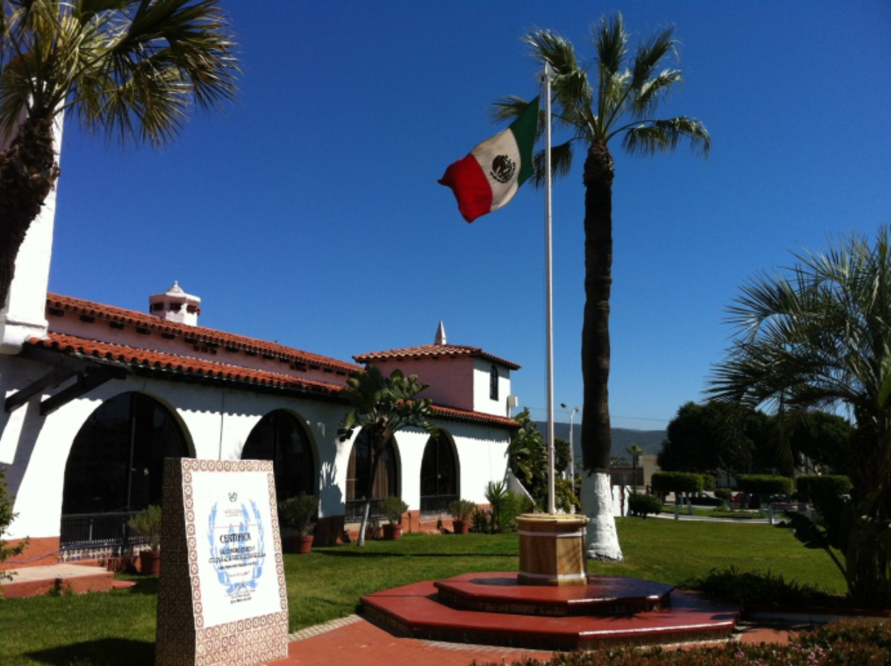
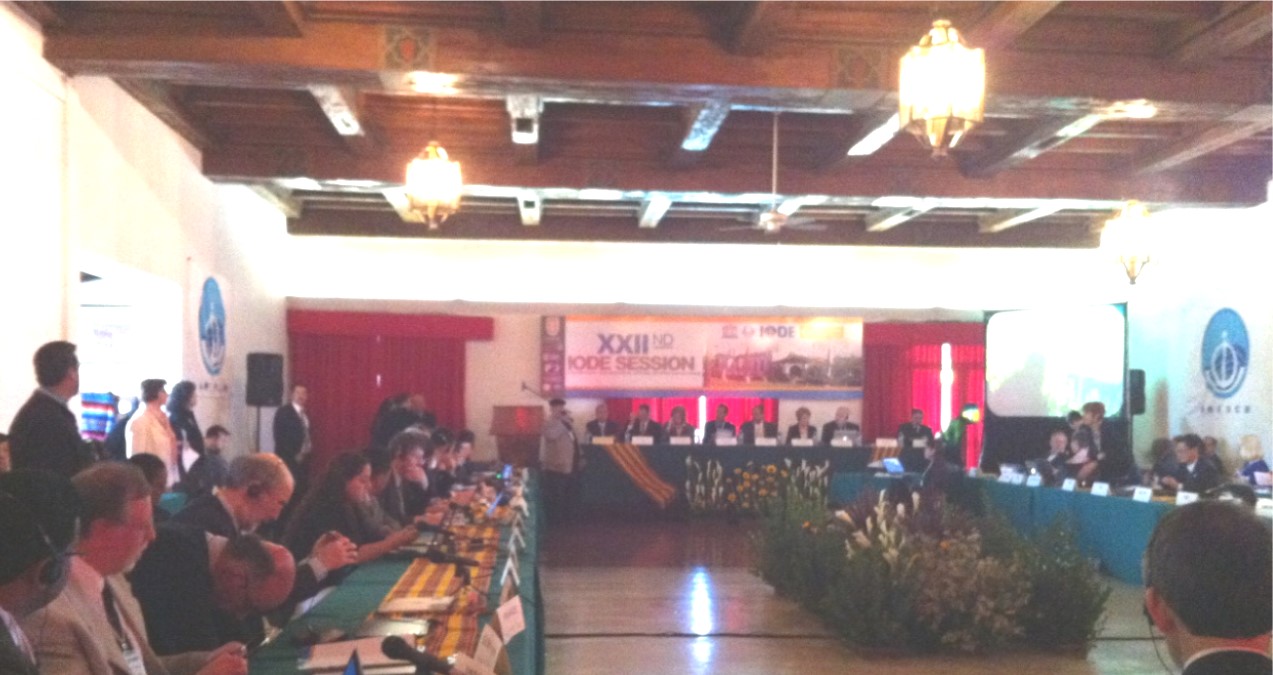
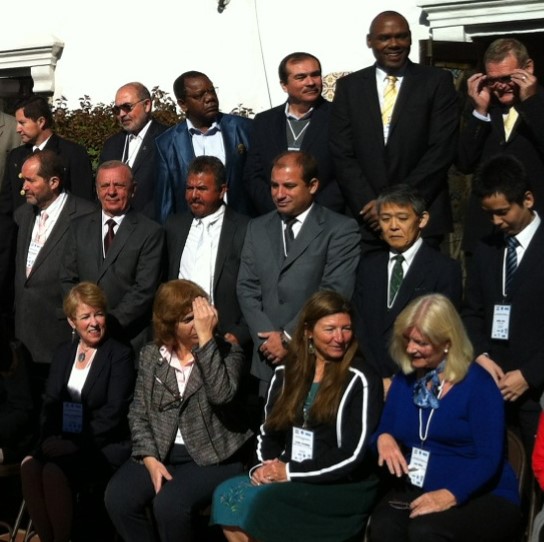 At the 22nd Session of the International Oceanographic Data and Exchange (IODE) committee of the UNESCO Intergovernmental Oceanographic Commission (IOC) that concluded in Ensenada, Mexico on 15 March 2013, ICAN was accepted as an official project of the IODE. A modest budget through until 2015 was also approved. In the recommendation leading to the approval, the IODE noted “with appreciation that ICAN has already influenced, guided and informed users on development and use of coastal and marine web atlases, through periodic workshops and international conferences held in 2006, 007, 2008, 2009, and 2011.” and acknowledged “the importance of atlases as interdisciplinary products that assist decision makers .” The recommendation also encouraged Member States to support the development of IODE/ICAN.
Members of the Interim Steering Committee for the IODE/ ICAN Project
| Name | Affiliation |
| Ned Dwywe | CMRC. Ireland (Chair) |
| Roger Longhorn | EUCC, Belgium |
| Angora Aman | ODINAfrica, African Region |
| John Bemiasa | ODINAfrica, African Region |
| Marcia Berman | VIMS, USA |
| Héctor Huerta | SPINCAM, South America |
| Kathrin Kopke | CMRC, Ireland |
| Tony LaVoi | NOAA, USA |
| Adam Leadbetter | BODC, UK |
| Andrus Meiner | EEA, EU |
| Liz O Dea | State of Washington Dept. of Ecology, USA |
| Ramon Roach | Coastal Zone Management Unit Barbados (CMA), Caribbean Region |
| Lucy Scott | ASCLME, African Region |
| Dawn Wright | ESRI Chief Scientist, USA |
Dawn Wright, who represented ICAN at the meeting, stated in her message to ICAN members after the project was approved that “our acceptance into IODE gives ICAN some long-term sustainability in terms of both international notoriety and funding, also with acknowledgement of the important role that coastal web atlases play within the overall universe of oceanographic data management, decision-support and associated capacity building. Now that we are under the umbrella of IODE, we are also linked to other important efforts” such as GOOS (Global Ocean Observing System), ICAM (Integrated Coastal Area Management), GEO/GEOSS (Group on Earth Observations/Group on Earth Observations System of Systems).
The strategic goal of the IODE / ICAN Project is to encourage and help facilitate the development of digital atlases of the global coast, based on the principle of distributed, high-quality data and information, at local, regional, national or international scale. This will be achieved by sharing knowledge and experience among atlas developers in order to find common solutions for coastal and marine web atlas development while ensuring maximum relevance and added value for users. Many of these atlases will play an important role in informing national and regional decision- and policy-making across several themes, including: marine spatial planning, climate change impacts, coastal vulnerability, coastal governance (boundaries, protected areas, etc.), coastal conservation and protected areas management, coastal hazards monitoring and planning, coastal disaster management and mitigation, population pressures and resource availability and extraction. The participants in the Project will include all experts previously involved in ICAN as well as other relevant experts designated by IOC Member States. An interim Steering Committee has been established. The members of the Steering Committee are listed in the table above.
ICAN Tech Team Member Roy Lowry receives IODE Achievement Award
- Detalles
- Categoría: News News
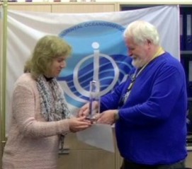 Roy has made numerous contributions to IODE over the past 3 decades – beginning with the software to accompany General Format 3 (GF3) in the 1980s – an early attempt at interoperability! The (GF3) system was developed by IODE as a generalised formatting system for the exchange and archival of data within the international oceanographic community. The next stage of Roy's career was spent compiling integrated data sets from major multidisciplinary oceanographic field programmes for UK, European and international projects, including leading the Joint Global Ocean Flux Study (JGOFS) Data Management Task Team. This also included a lot of work on controlled vocabularies which has evolved into one of his main areas of interest and impact. In particular, over the last 10 years or so, he has focused on the development of semantic infrastructure both in terms of technical and content governance.
Roy is responsible for the semantic framework underpinning the EU SeaDataNet project (which includes IODE) and has also led the ontologies work package for the NETwork for MARine Environmental Data (NETMAR) project and the ICAN coastal erosion and water quality ontologies. One final area of Roy's influence which should be mentioned is his contribution to the emerging subject of data publication and citation, through his contribution to the workshops and case studies of the joint project established between SCOR, MBLWHOI and IODE to investigate this topic. One last comment: Roy is a person who likes to get things done – and done properly! And he is always happy to discuss areas of interest whether in a workshop or over some beers! ICAN would add its appreciation to the that of the IODE for Roy's tremendous achievements.
Liz O’Dea said “Roy has been a valuable contributor to the ICAN Technical Working Group since ICAN’s inception, sharing his knowledge and providing great insight.”
(Extensive excerpts were used from the presentation speech published on the IODE website www.iode.org which also has a video of the award presentation.)
Small but complex: an atlas for the Belgian coast
- Detalles
- Categoría: News News
Kathy Belpaeme
Coordination Centre, ICZM
Esta dirección de correo electrónico está siendo protegida contra los robots de spam. Necesita tener JavaScript habilitado para poder verlo.
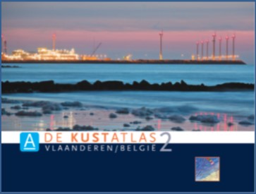
Figure 1: The cover of the 2nd edition of the Belgian coastal atlas
With its 67 km, the Belgian coast seems tiny compared to the neighbouring countries. Its importance and complexity is, however, not less important. Mapping all the uses and users in an atlas proved very helpful, both for the stakeholders and the general public to understand the need for a coordinated management.
The Belgian coastal atlas was first published in book format in 2004, and updated in 2011. The online version was launched in 2005, and revised thoroughly in 2011 and is available in four languages.
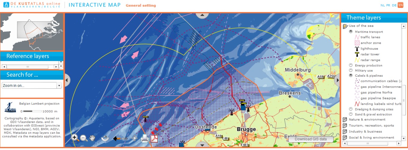
The atlas is appreciated as a portal for the Belgian coast and sea, supporting the ICZM process for a wide range of coastal actors, planners and managers. It provides core information through an interactive website, to help local citizens, stakeholders and policy makers make better decisions or gain a better understanding of the coast. Great attention has been given to an attractive lay-out and the ease of navigating through the website. The information is thematically arranged in 13 chapters, taking the land-sea interface into consideration. Each chapter provides static, ready-to-use maps, coastal data and an interactive map. All static maps can be downloaded in PDF format; the data in excel format. The interactive map contains tools such as measuring, zooming, and printing. Furthermore, the sustainability indicators are integrated into the Coastal Atlas. Twenty-one indicators are grouped in seven chapters, giving an insight to the state of the coast and the sustainability of its development. Examples of indicators are: the age percentage of residents in the coastal communities, the extent of sea level rise or the amount of waste per household. Whenever possible, the indicators are visualised geographically on the interactive map, showing differences between the municipalities.
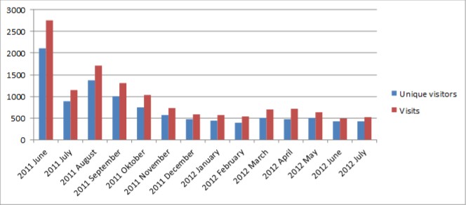
Since the launch of the second on-line atlas in June 2011, the web statistics tool used has changed. Consequently Web statistics before and after June 2011 cannot be compared. The figure shows the trend for the total number of visits and the number of unique visitors since the launch in June 2011 until website and why. The results of the poll showed that people mainly look for: general info on the coast, the interactive mapping tool and touristic information (= top 3), and that the profile of the visitors is very diverse. Clearly all different sorts of people find their way to the website. The book version of the Coastal Explorer has been officially launched on 1 September 2012. The launch was embedded in the three day workshop of ICAN, the International Coastal Atlas Network, taking advantage of the international scene of this conference.
It is crucial that the data of the atlas is kept up-to-date. Interaction with data holding and management authorities is very important in achieving this goal. A working group meets yearly to evaluate the atlas. Receiving feedback from the users is also very valuable to highlight any problems or needs.
DE KUSTATLAS online http://www.coastalatlas.be/en/
Washington Coastal Atlas Continues Upgrade
- Detalles
- Categoría: News News
Liz O’Dea
Washington State Department of Ecology
Esta dirección de correo electrónico está siendo protegida contra los robots de spam. Necesita tener JavaScript habilitado para poder verlo.
The Washington Coastal Atlas (https://fortress.wa.gov/ecy/coastalatlas/) team has completed phase two of its three-phase redesign project. In addition to its new look and feel, the atlas now has four use-specific tools that users can access directly from the home page.
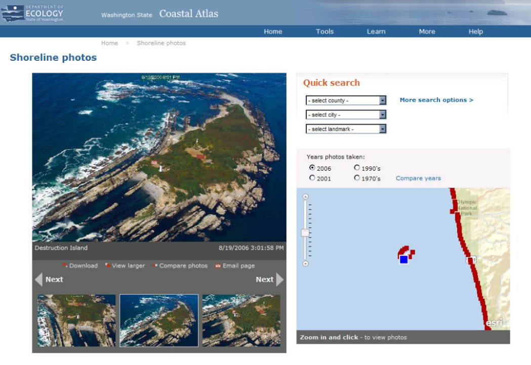
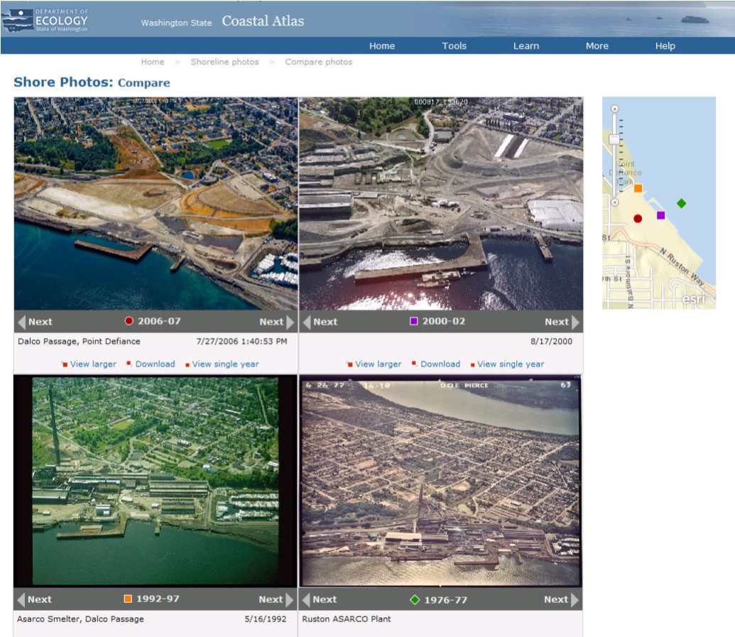
Shoreline Photos: The Washington Department of Ecology’s oblique photo time series of Washington’s marine and freshwater shorelines has been the most widely used component of the Coastal Atlas over the years. The new Shoreline Photo viewer improves the ease of finding a photo for a specific area from multiple time periods. The viewer enables users to quickly navigate through images along a shoreline and simultaneously see the location on a map. It also provides a comparison page, where users can view the same area over time from the collection of years. Each year’s photos can be independently navigated so that the user can choose the images that allow the best shoreline comparison.
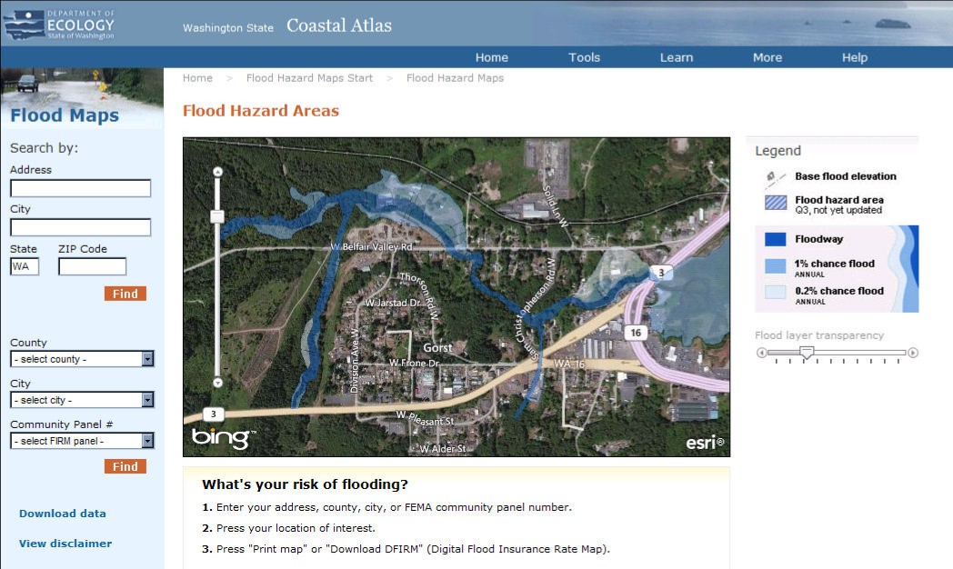
Flood Hazard Maps: A new viewer for FEMA flood maps makes Digital Flood Insurance Rate maps downloadable directly from the Coastal Atlas, which helps inform real estate decisions and transactions. The ability to view flood maps superimposed on aerial photography helps people better understand flood issues within the context of the landscape.
Public Beach Access: Public access is only available on about 30% of Washington’s marine shorelines, and the public’s right to access the shoreline is one of the three pillar policies of Washington’s Shoreline Management Act. We have made it easier for people to discover where they can access the shore. People can find beaches by name, location, or by specific amenities or activities. Beach information includes photos, amenities, directions, and links to tides, weather, and local information sources.
Beach Closures: Users can also find beach closure information and monitoring results for all locations monitored by the Dept. of Ecology/Dept. of Health BEACH program.
Former Washington Coastal Atlas Manager and ICAN member Kathy Taylor has transitioned to another position in the Department of Ecology. She was a wonderful leader who guided us through the first two redevelopment phases, and was a strong cheerleader on the value of the Washington Coastal Atlas for the people of Washington State. Her replacement, Brian Lynn, has been involved with the Coastal Atlas for many years and leads us forward through our third phase of redevelopment: migrating the Washington Coastal Atlas Map from ArcIMS to ArcGIS Server using the JavaScript API, including a new interface design. This is due to go live in November.
Regional Data Management and Portal Design Workshop / New Marine Planning Listserv
- Detalles
- Categoría: News News
Adam Bode
NOAA Coastal Services Center
Esta dirección de correo electrónico está siendo protegida contra los robots de spam. Necesita tener JavaScript habilitado para poder verlo.
The NOAA Coastal Services Center hosted a Regional Data Management and Portal Development Workshop in Charleston, SC on June 27-28, 2012. The objectives of the workshop were to build awareness among participants of the status of existing regional and national marine information systems; develop strategies for integration of national and regional coastal and marine data and systems-related activities; identify common data management and exchange standards and procedures; and identify methods to increase collaboration among marine data management groups. The workshop report can be found here: link
Based on feedback received during this workshop, the ocean.data.gov team recently created the Marine Planning Portal Network listserv, which will serve as one of the main conduits for communication between state, regional, and national portals, applications, and planning efforts. As systems become more distributed and technology continues to evolve, the need to share information (lessons-learned, best practices, etc) and provide a venue for open dialogue is paramount. This listserv is designed to serve this purpose. If you are interested in joining the listserv, please visit the following link to register - link
In addition to the listserv, the following ideas have been discussed to help spark engagement and continue the discussions from the Workshop:
- Webinar Series - The frequency of these is still to be determined but the initial thought is to have them every other month, focused on the following
- Round Robin Updates - Short updates on the current status of state, regional, and national efforts. Used for quick information sharing and also to spark interest in technical topics, issues, or additional discussion
- Featured Presentation – In-depth presentations/demonstrations of existing products or beta releases
- Technical / Topical Discussions – Based on the input from the Network, these could focus on a certain technical issue, topic, or discussion point. For instance, this could be the start of a discussion on a Network-wide metadata strategy.
- GeoTools Conference Tools Showcase - Similar to the Map Gallery at the ESRI UC, this is an informal opportunity to present/demo your tool and application. A dedicated space may be available to highlight the various state, regional, and national applications and portals.
- Oral Presentation - Based on interest, there may be a track or session dedicated to Regional Data Management and/or Portal Design.
- Informal Network Lunch/Happy Hour - Lastly, there are plans to re-design the Technical Community of Practice (link) within the Ocean Community to serve as a landing page for this Network. The new webpage will more effectively provide access to the best practices and resources most relevant to your efforts and serve as a location where a variety of information relevant to this Network can be accessed.