
The West Coast Ocean Data Portal (WCODP) began in 2014 as a project of the West Coast Governors Alliance on Ocean Health (WCGA). It was launched with the intention of increasing access to and discovery of critical ocean and coastal data for resource managers and policymakers on the West Coast of the United States, and parallels the efforts of other regional data portals around the U.S. The WCGA is no longer active, but the WCODP maintains its original purpose and now works in close coordination with the West Coast Ocean Alliance (WCOA), taking guidance from the WCOA on the development of data products. The WCOA is a Regional Ocean Partnership formed in 2018 from the legacy of the former WCGA and West Coast Regional Planning Body, and is composed of state, tribal, and federal representatives involved in coastal and ocean management on the West Coast.
Technical Enhancements
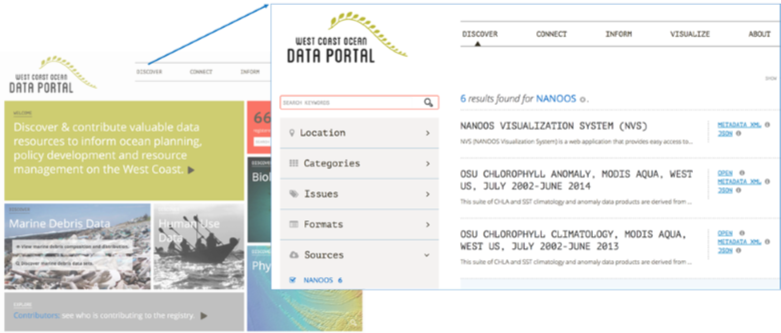
At the end of 2019, the portal received several technical upgrades. These included an update of the content management system to Wagtail, to allow for easy maintenance of the front end, and an update of the portal visualization tool to Open Layers 5. The move to Open Layers 5 has allowed support for time-enabled web services and for vector tiles; coupled with the new content management system, this simplifies the creation and publication of story maps that highlight resources available through the portal.
This year, the WCODP is continuing to build on these upgrades, and work is being done on the portal to update the geoportal software, rewrite the application program interface (API) and front-end for the portal’s catalog browser, and integrate the catalog and portal functions. When completed, these upgrades will not only improve the overall functionality, query and visualization abilities of the portal, but will also improve efficiency of portal maintenance. In the current iteration of the portal technology, the catalog and visualization tool are not connected, and must be updated individually to make sure that visible layers can be found in the catalog. Portal staff envision that integrating these components will reduce required maintenance effort, and free up time that can be spent improving other aspects of the portal.
Data Projects
In addition to these technical enhancements, the WCODP is focusing on the creation of a number of other data improvement projects to be hosted on the portal, that will improve access to information and be helpful for planning and communication purposes for our users.
West Coast Ocean Health Tool
In 2019, at the request of WCOA members, the WCODP began preliminary work on the creation of a West Coast ocean health scorecard tool, in order to define standards and critical thresholds concerning priority ocean health issues across the region. Thus far, this process has involved a review of existing ocean health tools, including scorecard products and frameworks, and the selection of three priority indicators to be developed by the end of 2020: ocean acidification, beach water quality, and macroalgae. Altogether, the anticipated timeline for this project is three to five years, and as indicator development with partner entities continues, the WCODP will work with WCOA members to determine the best way for users to interact with indicators via the portal interface.
Spatial Coordination Framework
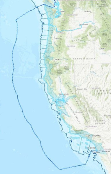
WCOA members have also asked for a tool to facilitate communication and identify key contacts as they relate to ocean and coastal projects developing on the West Coast. The COVID-19 pandemic has eliminated many opportunities for in-person communication on this subject, and the WCODP plans to develop this tool throughout the rest of 2020. The tool will be founded on a spatially enabled database of contacts, ocean management topics, and general ocean geographies for coordination. The preliminary geographic extents pictured below (Figure 2) create a generalized way for state, tribal and federal staff members to self-identify their interest in ocean management topics in a particular geographic region. By choosing a geographic area or topic to search by, members can then identify all related entities and staff members that would like to be notified or have expertise for that topic / area. Example topics include, but are not limited to, subjects such as aquaculture, energy, submarine cables, fisheries and sediment management. The tool will not replace regulatory or organizational responsibilities, such as required Government-to-Government consultations with West Coast tribes.
Oregon Offshore Wind Planner
In 2019, renewed interest in offshore wind development off the coast of Oregon led to the revival of the Oregon and Bureau of Ocean and Energy Management (BOEM) Intergovernmental Renewable Energy Task Force. This Task Force consists of representatives from federally recognized tribes, federal agencies, states, and local governments, and serves as a forum to coordinate planning and engagement around the development of offshore renewable energy resources, specifically wind. In the Task Force’s recently released Data Gathering and Engagement Plan, the WCODP is identified as the portal that will display all data related to offshore wind planning off the coast of Oregon, for government and stakeholder use. In addition to the relevant spatial datasets listed in the existing catalog, the WCODP is developing a standalone data visualization tool for this purpose over the course of the next year. This Oregon Offshore Wind Planner will offer a curated selection of the most up-to-date layers relevant to offshore wind planning in the area, along with other products such as pre-made maps according to different subject areas.
Get Involved
Altogether, this year is an exciting one for the West Coast Ocean Data Portal as we look forward to completing technical upgrades and unveiling new content and projects. These projects and regular portal maintenance are currently supported by a combination of funding from the National Oceanic and Atmospheric Administration, the Bureau of Ocean and Energy Management, and the Gordon and Betty Moore Foundation.
To learn more about the West Coast Ocean Data Portal, visit https://portal.westcoastoceans.org or
contact Marisa Nixon, West Coast Ocean Fellow, at This email address is being protected from spambots. You need JavaScript enabled to view it..
[Editor’s Note: An article on the West Coast Ocean Data Portal was last published in the March 2014 issue of the ICAN Newsletter.]