
by Adam Leadbetter, Team Leader for Data Management, Marine Institute
Ireland’s Marine Atlas (https://atlas.marine.ie) was initially developed as part of the national reporting for the European Commission’s Marine Strategy Framework Directive on the environmental status of the seas and oceans around the country. At its launch, Ireland’s Marine Atlas included content such as administrative boundaries, protected sites, oil and gas, ocean features, fisheries and aquaculture, marine monitoring, seabed habitats, tourism and leisure, transport, infrastructure, discharge point sources, International Maritime Organization protected areas and current/historical dump sites.
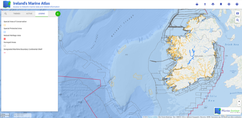 Figure 1. A screenshot from Ireland's Marine Atlas showing: special areas of conservation) orange hashed); special protected areas (blue hatched); and the survey lines followed throughout the INFOMAR seabed mapping programme (black lines).
Ireland’s Marine Atlas has supported a number of “user stories”:
1.Legislative Reporting to the European Commission
The Marine Strategy Framework Directive is European Union legislation that aims to protect the marine environment. It requires the application of an ecosystem-based approach to the management of human activities enabling sustainable use of marine goods and services.
Spatial data from Ireland's Marine Atlas has been used in Ireland's Marine Strategy Framework Report and Initial Assessment.
Ireland's Marine Atlas also supports the consultation processes making the public aware of Ireland's marine waters, the environmental status of those waters, and the ongoing human activities in the marine environment.
2. Assessing the Cumulative Impact of Human Activity in the Irish Sea
Maritime Spatial Planning requires the assessment of cumulative impacts in both forward planning and project decision making. Globally, there is an array of existing ecosystem-based methods for cumulative pressure and impact assessment. However there is a general lack of clarity on how these methods can be incorporated into the spatial planning process.
As part of the European Commission’s SIMCelt project on Marine Spatial Planning in the Celtic Seas, the Marine Institute developed a framework for the assessment of cumulative impacts of human activities in the Irish Sea. The approach is to compile data on human activities, interpret the pressures, and use this information to improve our understanding of the cumulative pressures and the impacts.
Maps illustrating human activities in the Irish Sea were produced for this case study using data from Ireland's Marine Atlas.
3. Offshore Renewable Energy
Ireland's Marine Renewable Energy Portal has been developed by the Sustainable Energy Authority of Ireland and the Marine Institute in accordance with the requirements of the Offshore Renewable Energy Development Plan.
Open data from Ireland's Marine Atlas is used in the Renewable Energy Portal's "Maps" and "Data" sections. The maps section also uses a customised version of Ireland’s Marine Atlas specific to the requirements of the marine renewable energy sector and provides data on:
- Geology and sediments
- Petroleum energy
- Tidal energy resource
- Wave energy resource
- Wind energy resource
Data provided by Ireland's Marine Atlas supports spatial information, visualisation and increased understanding of the marine renewable energy resource.
In addition, it is consistent with the requirements of the Offshore Renewable Energy Development Plan by making data and information available to the public and potential developers.
4. Visualising Marine Landscapes
Mapping of visual impacts on marine landscapes typically relies on a combination of GIS and viewshed analysis-based methods.
Research in Queen's University Belfast, funded by the Marine Institute’s Cullen scholarship programme for post-graduate research, has investigated the potential visual impacts and the public attitudes regarding the deployment of offshore windfarms off the west coast of Ireland.
This research used data from Ireland's Marine Atlas and also incorporated data from Failte Ireland and NASA’s Digital Elevation Model.
In addition to these use cases, in 2019 the Marine Atlas content was completely refreshed in order to support the publication of Ireland’s draft National Marine Planning Framework documentation. Work is ongoing to continue the publication of data layers relevant to the Marine Spatial Planning activity in Ireland through Ireland’s Marine Atlas platform.
Technically, the map viewer used in Ireland’s Marine Atlas uses a Leaflet JavaScript mapping framework front-end to access Web Map Services and Web Feature Services from both proprietary (ESRI-based) and Open Source (GeoServer) back-ends.
Each layer in Ireland’s Marine Atlas is described by a full ISO19115 metadata record which is registered either in the Marine Institute’s data catalogue (http://data.marine.ie) or in the Irish Spatial Data Exchange (http://isde.ie). These records are made available to a more general audience through harvesting to Ireland’s Open Data Portal (https://data.gov.ie).
Future development of Ireland’s Marine Atlas will be targeted at closing the gap between the static map-based interface and the presentation of real-time and delayed-mode observational data through Ireland’s Digital Ocean platform (https://digitalocean.ie).
Ireland's Marine Atlas viewer has been part supported by the Irish Government and the European Maritime & Fisheries Fund (EMFF) as part of the EMFF Operational Programme for 2014-2020; the Department of Agriculture Food and the Marine; and the Department of Housing, Planning and Local Government. Ireland's Marine Atlas is operated by the Marine Institute, the State agency responsible for marine research, technology development and innovation in Ireland. Development of the current version of the viewer was undertaken by Compass Informatics Limited.
A video showing the use of Ireland’s Marine Atlas can be seen at
[Editor’s Note: An article on the Irish Marine Atlas was last published in the ICAN Newsletter in the March 2012 issue.]