
By Carolina García-Valencia, Leonardo Arias-Alemán, Paula C. Sierra-Correa y Francisco Arias
Instituto de Investigaciones Marinas y Costeras “José Benito Vives De Andréis” – INVEMAR
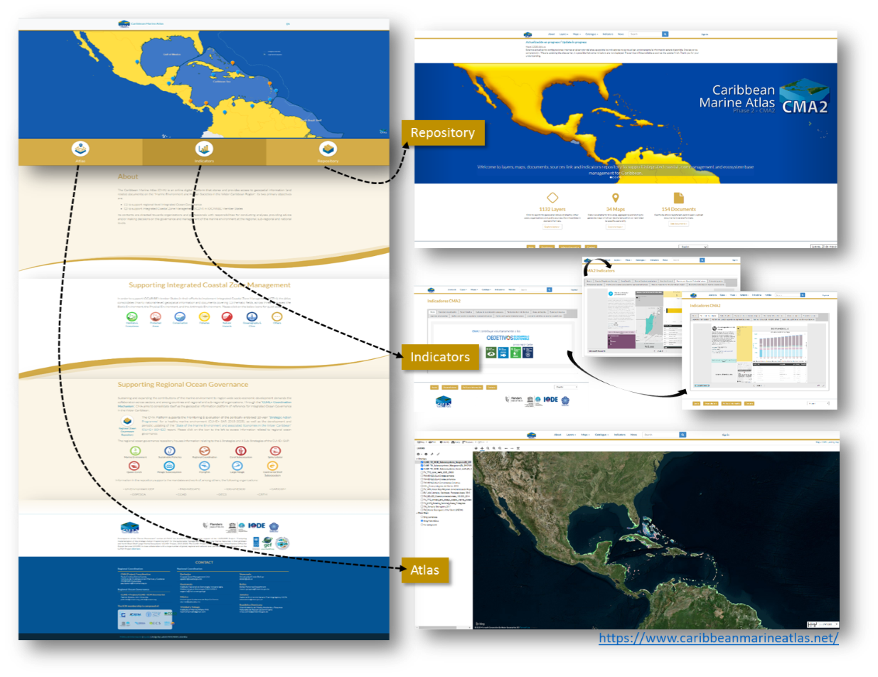
https://www.caribbeanmarineatlas.net/
The Caribbean Marine Atlas (CMA) project on its second phase (2016-2020) faces the challenge of transitioning into an electronic repository for quality technical and scientific information of the Caribbean Basin, with the purpose of being a tool for decision-making in the entire region.
The Platform offers data and information on different issues related to Integrated Coastal Zone Management (ICZM), Ecosystem-based Management (EbM), and regional governance at several spatial scales, from the management of user administrators assigned to information/data providers and remote geospatial information services of interest to the region. Through the involvement of participating countries, CMA seeks to support decision-makers, and society in general, so everyone who has any need for information from the Caribbean is able to consult this information free, online, and automatically. At present, the platform offers 1134 layers, 145 maps, 154 documents, 93 linked external information sources, and 24 remote services (WMS/WFS). In addition, due to special interest from partner countries, a report of a set of indicators was generated, which has led to an opportunity to publish ten indicators that identify corresponding gaps in information for the major problems and challenges of the Caribbean region and seeking to use national data from country partners regarding environmental/economic information.
The ten indicators are:
- Coastal population density change (municipalities),
- Coral Health –assessment of reef biota (% cover) (Healthy Reefs Initiative),
- Marine Protected Areas,
- Ecosystems Representativeness (The spatial extent of ecosystems in marine and coastal protected areas as a proportion of the total
- ecosystem extent in the country - mangroves, seagrasses, coral reef, and beaches),
- Coastal economic activities (% GDP by economic activity by political-administrative division of the 1st level),
- Threatened Species (National data / OBIS),
- Invasive Species (National data / OBIS),
- Extreme events (Effects for nine natural hazards: losses of human lives, and frequency of events: tsunamis, storm surges, wind, earthquakes, volcanic eruption, landslides, floods, drought and, hurricanes),
- Sea Level trend (NOAA data and sea level national stations) and
- Global Capture Production (marine capture production by country - FAO data).
Several of these indicators were defined to contribute as a voluntary report for some United Nations Sustainable Development Goals (SDGs), especially SDG 14 (https://www.caribbeanmarineatlas.net/indicatorscma2).
 Caribbean Marine Atlas
CMA is based on a collaborative approach to strengthening national capabilities from existing national, regional and international marine data and information management programs, projects or strategies of International Ocean Data and Information Exchange (IODE) (cooperation exchange and expertise, strategic synergies, opportunities and tools). The technological tool allows countries self-management over information, which enhances its capability on spatial information management as well as display and publishing opportunities (GIS expert trained/country). Information management involves metadata and standards use, information policy (IODE information Policy www.iode.org/policy), protocols to upload products and quality control. Among the main tools the platform offers is a large repository for geospatial information (layers, maps, documents), a geospatial viewer to freely consult/create/download of maps and layers (shapefile, raster, WMS), display of indicators (graphs and tables), links to other online data sources and a news module.
The adaptation of the platform from the functionality of its graphical user interface offers a repository of geospatial data and information that can be retrieved, stored, periodically updated and made available for particular purposes of a project, agency or initiative. With the technical assistance carried out by the platform administration (INVEMAR), its operation based on GeoNode technology is guaranteed, as well as interoperability with other systems. Linkages with the CaribbeanLarge Marine Ecosystems CLME + project have shown that the visualization of information hosted in the Atlas is possible through graphs and maps for specific purposes allowing the improvement of its services, the activation of its interoperability and the articulation with other initiatives to achieve a technological synergy that links it to other websites dynamically through the GeoNode infrastructure and the caribbeanmarineatlas.net domain. This enhancement of interaction with other regional projects/initiatives or interested countries is increasing the amount of information and the spectrum of topics for the Caribbean region. The CMA landing page was updated to make a visible supporting role in the regional Strategic Action Programme Monitoring & Evaluation (SAP) and State of the Marine Environment and associated Economies (SOMEE) reporting efforts. Currently, it provides relevant background upfront, as well as a shortcut to access information that specifically relates to certain aspects of the CLME+ SAP (and thus the SOMEE report, whose structure is based on the SAP), hyperlinks to various pages on the CLME+ HUB, acknowledgments and regional ocean governance contacts. At the same time, the CLME+ HUB also links back to the CMA GeoNode (https://clmeplus.org/ ).
The creation of custom layer-based visualizations contributes to the strategic positioning of GeoNode technology, and in particular, its practical expression in the form of the CMA platform with information workflows associated with decision-making processes. In this sense, the Caribbean Marine Atlas can be the tool that marks the beginning of a new chapter for the use of GeoNode in the management of geospatial platforms and Spatial Data Infrastructures in the Caribbean region, and for its effective and long-term use to support the management of marine resources, governance and even management at the transboundary level.
Since 2020 CMA moves forward toward a new phase, in which in addition to initial objectives as a project on the region, the platform will be part of the catalog of the set of sources/systems for geospatial products (maps and atlases) of the Ocean Info Hub project (see article below). This last project is currently being developed by IODE of the Intergovernmental Oceanographic Commission IOC (UNESCO). It is a new initiative to streamline access to ocean science data and information for management and sustainable development that will center on an openly accessible web platform designed to support interlinkages and interoperability between distributed resources including existing clearinghouse mechanisms within the framework of United Nations Decade for Ocean Science for Sustainable Development.
[Editor’s Note: The CMA last appeared in the ICAN Newsletter in the November 2016 Edition.]