
by George Edmonds Jr. This email address is being protected from spambots. You need JavaScript enabled to view it.
The updated Coastal Atlas Site is an online mapping and planning site that allows state and local decision-makers to visually analyze and explore data for coastal and ocean planning activities. From this platform a user can visualize, query, map, and analyze coastal data to better manage Maryland's marine and estuarine resources. Map layers include standard data which supports decision-making for future ocean, near-shore and estuarine activities by highlighting current uses, resources, and risks. New map layers and tools are continually added to the atlas with the newest group of Map service layers being added for Beneficial Use datasets which are available for viewing and analysis now.
The Portal links to three main products include the Interactive Mapper, iMap Open Data Portal and the GIS Catalog plus several digital assistance product sites. These digital data products include Map Stories, Step by Step Guides and links to other key geospatial data hosting locations. The Coastal Atlas has an Add Data widget that allows users to bring in other mapped data from multiple formats including Third Party map services and local spatial datasets.
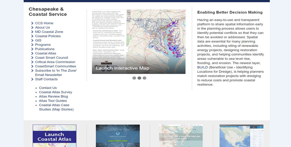
Figure 1: The Main Page for the Maryland Chesapeake and Coastal Service
(https://dnr.maryland.gov/ccs)
Interactive Mapper
The interactive mapper Coastal Atlas, a customized ESRI Web Application Builder app, can be launched from the Coastal Atlas main URL page. Online tools for the Coastal Atlas have been developed to support better decision-making and address specific coastal issues. Users can use the measuring tool to measure shoreline fetch, the draw tool to draw a box around a specific area, or the identify tool to get more information about the data to highlight to mention just a few. Users can also work with the Maryland Department of Natural Resources (MDNR) to generate targeting queries that help specific users to narrow spatial data for focus areas. The Atlas offers many tools to assist users in understanding and analyzing detailed geospatial data residing on the map application. The Transect Tool can be used to calculate the amount of shoreline erosion using the Rates of Change dataset values for a location of interest in the Chesapeake Bay. MDNR and the Maryland Geological Survey (MGS) collaborated on the research, analysis and integration of that modeled data. There are several ways to launch the Coastal Atlas from the main page seen above.
The technology facilitated is ESRI Web Application Builder (WAB) platform which is used to build and customize the Maryland Coastal Atlas Interactive Map. The Maryland iMap hosts ESRI REST map service from an SQL based Enterprise GIS that can be easily consumed by a JSON based map application. The Maryland Coastal Atlas layers include key mapped datasets such as Bathymetry, Blue Infrastructure, Coastal Resiliency Assessment, Living Resources, Parcel Boundaries, and SAV (submerged aquatic vegetation) Last 5 Years. Most of the layers are there to compliment the planning tools that can aid in evaluating the feasibility and social or environmental benefits of resiliency and many other types of projects.
Open Data Portal
The Open Data Portal offer numerous, additional geographic and non-geographic data sets, available for users to search. Built-in tools allow for visualization of the data in a table, graph or map format. The Portal is managed by Department of Information Technology (DoIT) with contributions from many Maryland State agencies. And again, the use of the Add Data Tool allows for other Third-party map services or even local datasets to be added into the interactive mapper.
GIS Catalog
The Maryland GIS Data Catalog has a Quick search capability for the latest data and geographic content from Maryland contributors. Use keyword or geographic searches to find and quickly display content. Also, the capability to download data into multiple formats or access via APIs for local use is possible.
Additionally, there are tools for accessing state Imagery, Lidar and data downloads. Map Service information and links are available to all the Map layers offered by the State of Maryland’s iMap with comprehensive Metadata for the spatial data.
There are several types of digital assistance for the Coastal Atlas users to facilitate which includes a basic Step by Step Guide for individual tools/widgets, Contact Us form for questions or concerns and Map Stories showing projects which have used the Atlas for spatial planning.
Stories
The Atlas Map Stories are case studies of work that has been done and some which are ongoing that show how the Coastal Atlas offers tools for strategic project planning. The Map Stories include Coastal Resiliency, Land Conservation, Recreational planning, Working Waterfronts and the newest Beneficial Use (BUILD). More planning resources expect to be added as the Coastal Atlas continues to be retooled and facilitated over time.
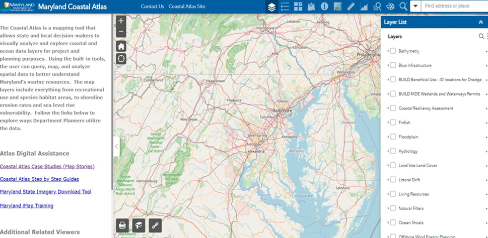
Figure 2: Image from the Maryland Coastal Atlas showing
part of the list of data layers available to the user
BUILD Tool
Aptly named, The Beneficial Use: Identify locations for Dredge, aka. BUILD tool is the newest addition to the Coastal Atlas line of planning resources. BUILD is a set of online mapping layers in the Maryland Coastal Atlas that are intended to enable spatial, temporal, and physical identification of beneficial uses with dredging projects. BUILD can be used to proactively identify beneficial use opportunities to provide environmental and resiliency benefits, while simultaneously reducing material transportation and fill costs. To learn more about how BUILD has been used to identify beneficial use projects, visit the BUILDing Resilience story map.
Some examples and excerpts, available online, mentioned here of Beneficial Use Digital Assistance:
"To ensure that the environmental benefits uphold the financial benefits, the Maryland Department of the Environment (MDE) published the Innovative Reuse and Beneficial Use Guidance Document, which provides guidance on the implementation of and physical and chemical standards for using dredged material in innovative reuse or beneficial use projects.
Similarly, the Maryland Department of Natural Resources (MDNR) is pursuing the beneficial use initiative through the development of: https://dnr.maryland.gov/ccs/Pages/beneficial-use.aspx
- A policy and guidance
- On-the-ground implementation of beneficial use projects
- Decision-support tools to aid project planning and to overcome the associated hurdles
- Map Stories of people using Beneficial Use planning tool: https://maryland.maps.arcgis.com/apps/MapSeries/index.html?appid=c76b3b66b57747c6aca654a33db68f0a
Before using BUILD, review the MDNR policy, "Dredged Material Placement on Resources Managed by the Department of Natural Resources", and MDNR process, "Beneficial Use of Dredged Material Planning Process". If a beneficial use project is identified, review the Maryland Department of the Environment (MDE) document, "Innovative Reuse and Beneficial Use Guidance Document”, to assess dredged material chemical and physical appropriateness for the identified placement use. "
The Coastal Atlas has several things in place to derive key Feedback from users which includes indirect collection with Google Analytics (GA) and a more direct approach with a user Survey. Below are example images of some of the reports on the Atlas from Basic GA which is embedded in both the main launch page and the application itself.
Maryland Coastal Atlas Google Analytics (GA) Feedback Numbers Reports:
The Coastal Atlas Survey is facilitated through the Maryland State Standard platform Survey Select and is available on the Coast Atlas Main page along with a Contact Us option. The Contact Us can be used to get information from users or for users to ask questions about the Atlas and report errors. There is also a Contact Us button within the Atlas interactive Mapping application so users can report an error and drop in a screen shot of the exact error message.
Future directions for the Coastal Atlas will be to continue to revamp or redevelop the app to better suit the needs of the users. There is always a need to get better and more current map layer service data to replace or enhance the mapping datasets available on the Maryland Coastal Atlas. New initiatives for the Atlas include the addition of the Climate Ready Action Boundary (CRAB) data which designates mapped areas that fall within climate change affected locations. These locations could be more vulnerable or affected by flooding, sea level rise, storm surge and other climate change related environmental factors. Additionally, Chesapeake Bay coastal economic benefits data is also currently in the works to be put on the Coastal Atlas.
The creation of the Coastal Atlas has faced many challenges since its inception and with that several lessons learned throughout the process. The Coastal Atlas has had, in the past, many more tools and datasets that caused the application to be unwieldy. However, there is always a need for datasets that are a priority for planners and others to perform analysis or create maps for project work throughout the state of Maryland. The challenge is to balance those needs without overwhelming an application to the point it is no longer user friendly.
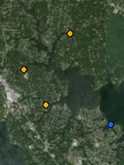
BUILD Data Layers
Living Shorelines Dredging Projects Cooperative |
Orange points - Waterways Improvement Fund upcoming dredging projects. Provide information on sediment type, DMP access, public land access, and approximate dredging schedule. These are updated when WIF projects are funded in April. Blue points - Indicate potential shoreline restoration projects identified by the Center for Habitat Restoration and Conservation. Provide information on the project scope, sand needs, and estimated project cost. These are updated when new restoration projects are identified. |
 |
Distance Buffers |
Two (grey) and four (green) mile radii can be added to the Waterways Improvement Fund upcoming dredging projects. These are the distances that dredged material can be reasonably hydraulically dredged. | 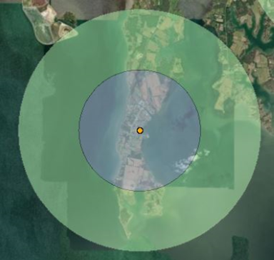 |
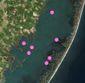
Lost Islands |
Pink points - Footprints of lost islands that have been identified by Wildlife and Heritage Service as potential island restoration projects that would benefit Maryland’s endangered waterbirds. These are updated when new island restoration projects are identified. |
 |
Boating Projects |
Provides detailed depth survey data for shallow water channels that MDNR has investigated (ReconSurvey, blue). Additionally, indicates locations of county DMPs (pink), tide board sites (red), Federal channels (COE channels, grey), and MDNR dredging projects (Dredge Project, yellow). These are updated when new projects are dredged or channels are surveyed. | 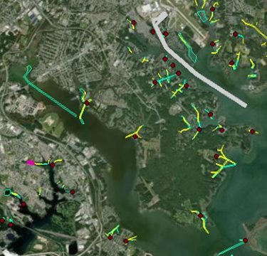 |
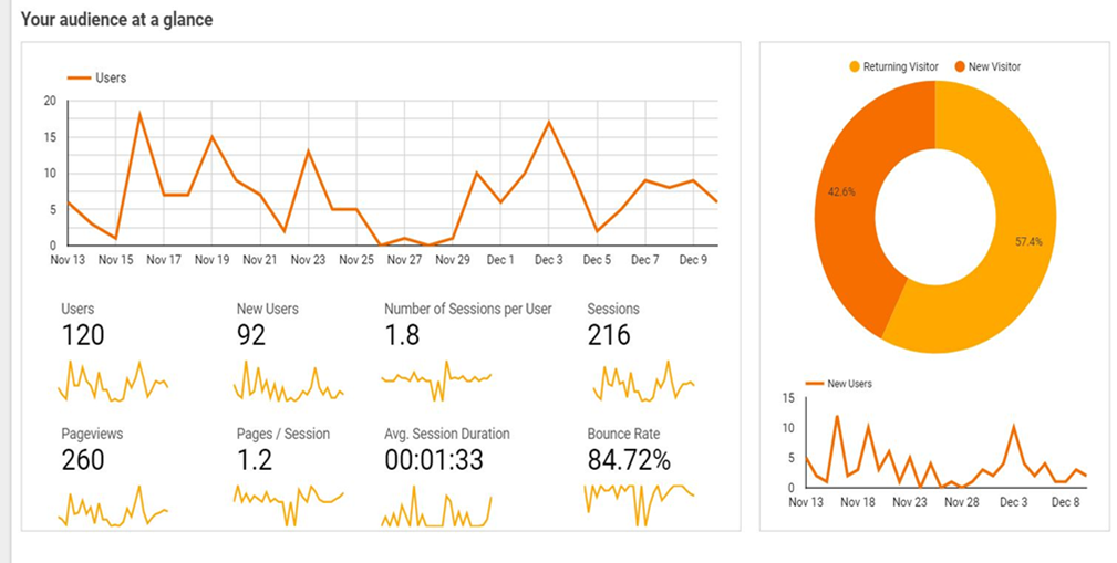
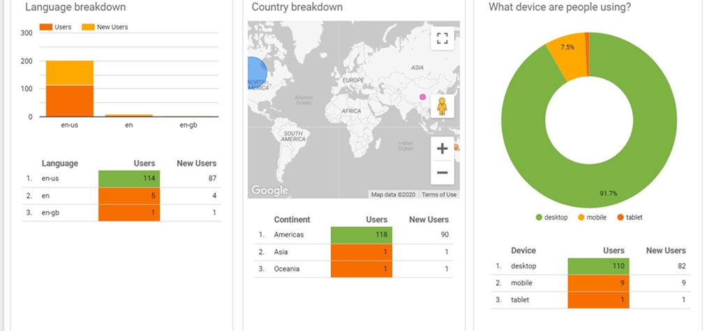
Figure 3: Maryland Coastal Atlas Google Analytics (GA) Feedback Audience Numbers Reports
Lessons Learned
One big lesson learned is the need for Feedback through surveys, etc. before the troubleshooting or complaints start to roll in. We will continue finding ways to unobtrusively gain responses about the Coastal Atlas from those who use the application regularly. The latter helps to determine the types of data and custom tools needed for the atlas.