
by Alejandro Iglesias Campos, This email address is being protected from spambots. You need JavaScript enabled to view it.
Government of Andulsia / Regional Ministry of the Environment
Preparing a new atlas interface to be online soon!
 The Environmental Information Network of Andalusia (REDIAM) will publish during 2012 a new coastal and marine atlas in Spanish and English with new functionalities and new contents. The new atlas interface will make easier all kind of search by citizens and technician using the Coastal and Marine Information System of Andalusia in their daily work.
Looking for new projects with our Portuguese colleagues!
The Portuguese Geographical Institute and the Environmental Information Network of Andalusia (Spain) together with other partners from the Mediterranean have applied to the European Neighborhood Policy Instrument Call with the AgoraMedGIS Project to promote the sustainable and integrated planning and management of marine and coastal zones in the Mediterranean Basin, making available universal access to data and geographic information and improve knowledge, the sharing of information and articulation between stakeholders. AgoraMedGIS - Marine and Coastal Mediterranean Basin Information System, is based on the "Ágora" concept, symbol of ancient Greece direct democracy. "Ágora" was the place where the citizens use to meet and share and discuss ideas and issues that were important to all. In this sense, the tool that will be developed by the partners allows the searching for multidisciplinary information that exists about a certain place, enabling the user to filter it accordingly to his own interest or focus, or selecting data by project type, activity or thematic area and related to the Mediterranean Basin in general or to specific zones. AgoraMedGIS will transform the entire Mediterranean basin in a small village in the domain of data.
Erosion rates 1956 – 2007 in our sandy beaches!
The erosion rates constitute a very valuable indicator for understanding coastal dynamics and its effects produced by river regulations (mainly by damming them) and the construction of coastal infrastructures.
In this sense, negative erosion rates (regressive coast) show more vulnerability; and positive erosion rates (progressive coast) show less vulnerability. After calculating the erosion rates for the entire Andalusian coast during the periods 1956-1979 and 1979-2007, some stretches have been chosen and validated as being of special interest due to the intensity in coastal dynamics: the coast of Huelva, the beaches/barrier of the mouth of the San Pedro river, Velez river delta, Guadalfeo river mouth, Adra-Albuñol and Huarea rivers, as well as the coast of Campo de Dalias.
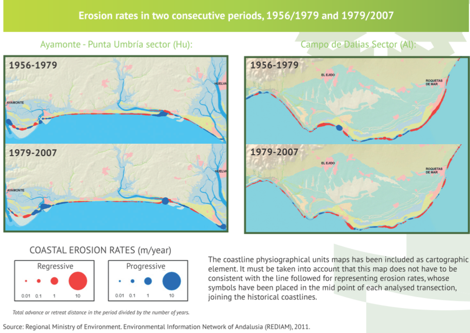
The first sector, located between the Huelva cities of Ayamonte and Punta Umbría, is characterised by having to highly changing zones at the mouth of the Guadiana and at the end of the Flecha de El Rompido and Flecha de Punta Umbría. In the sector between Mazagón and the mouth of the Guadalquivir river there is the beach and moving dunes complex of the Doñana National Park, one of the most characteristic examples of coastal progradation in Andalusia. On the other hand, the mouth of the Guadalquivir river is the most active stretch in this sector, reaching the positive rates of 10 m/year in the period 1956-1979 and up to 19 m/year in the period 1979-2007. In the province of Cadiz, in the beaches/ barrier of the mouth of the San Pedro river, it is worth remarking that the building of an industrial and port area altered completely the dynamics of the zone, which went from positive rates in the period 1956-1979 to erosion rates of up to -16 m/year in the period 1979-2007.
In the Mediterranean coast, at the mouth of the Velez and Guadalfeo rivers, there are two cases of deltas formed previously to the built-up of river mouth channels, which results in a general regression in almost all the stretches of both sectors.
The delta of Albuñol and Huarea rivers is different to the previous example, as the channelling of the mouth took place after 1956, and it does not have dams. For this reason an important progradation is shown in the first period.
The case of the Adra river, in the province of Almeria, is a “double delta” resulting from the artificial deviation of the original bed before 1956, which results, except in the oriental sector between 1956 and 1979, in negative rates in both periods. Finally, the case of the Campo de Dalias sector is highly singular, mainly because it is a stretch that receives no direct sedimentation from important river beds or watercourses. This, together with the urban growth of the 70’s, with the construction of ports and with the extraction of sand for greenhouses, has contributed to the fact the coast is, in both periods, mostly erosive.